
Is Xi'an a city or a county?
Xi'an is a sub-provincial city and the capital of Shaanxi Province. Its municipality contains 11 districts and 2 counties, so citywide population and geography extend well beyond the walled core.[1][2][3][4][5]
Shaanxi Province · Northwest China
Xi'an is Shaanxi's capital and a 13-unit municipality on the Guanzhong Plain. Chang'an history, the Qinling edge, archaeology, neighborhood food and contemporary life extend far beyond the walled core.
Xi'an is a sub-provincial city and Shaanxi's capital, with 11 districts and two counties represented in this guide's county-level map. The official 2025 bulletin records 13.2363 million permanent residents at year end. That municipal count includes the dense walled-city core, northern and eastern urban districts, Lintong heritage landscapes, Chang'an's mountain edge, and Lantian and Zhouzhi counties—not one uniform ‘ancient city.’
The city occupies the Guanzhong basin between the Wei River system and the northern Qinling. Water, loess terraces, alluvial land and mountain passes shaped settlement and routes, while today's reservoirs, drainage, roads, railways, farming, urban expansion and ecological protection create new relationships. Cuihua Mountain and Louguantai show only two points within a much larger environmental system.
History appears here as overlapping capitals, settlements and later cities: Banpo and other Neolithic sites; Zhou centers at Feng and Hao; the Qin mausoleum in Lintong while the Qin capital lay at Xianyang; Han Chang'an; Sui Daxing and Tang Chang'an; post-Tang regional urban life; the Ming wall city; rail, industry and universities; and today's metropolitan construction. Modern displays, reconstructions and tourism must not be mistaken for untouched survivals.
Climate context and live conditions are separate. Long-term profiles describe four distinct seasons, hot rainy summers and cold, comparatively dry winters, but heat, storms, air quality, mountain weather, trail closures, venue reservations, metro service and crowd levels change by date and district. This edition supplies background; current forecasts, warnings and operator notices govern decisions.
[1][2][3][4][5]Xi'an is a sub-provincial city and the capital of Shaanxi Province. Its municipality contains 11 districts and 2 counties, so citywide population and geography extend well beyond the walled core.[1][2][3][4][5]
Xi'an lies on the Guanzhong Plain, with the Wei River system to the north and the Qinling Mountains rising to the south. This east–west corridor shaped farming, settlement, imperial capitals, and modern transport.[1][2][3][4][5]
Capital history continues through archaeology, place names, museums, and public narratives.
Trade and movement connected religions, technologies, objects, and artistic practices.
Wheat-based dishes and market streets connect region, migration, and daily life.
Walls, rail lines, campuses, housing, and new districts reveal continuing urban change.
Twenty-five locally hosted, rights-cleared visual records move from the wall, towers and metro to archaeological sites, museum objects, living religious places, a neighborhood night street, Qinling landscapes, performance and food labor. Captions distinguish what is visible from site identity, dated conditions, reconstruction, collection location and claims that still need live or institution-level evidence.
Xi'an occupies the Guanzhong Plain between the Qinling Mountains and the Loess Plateau. The municipality reaches far beyond the walled core.[1][2][3][4][5]
The Wei River plain, Qinling foothills, waterways, and a broad metropolitan footprint frame both ancient settlement and present growth.
A fertile east–west corridor supported major capitals, agriculture, roads, and contemporary urban expansion.[1][2][3][4][5]
The municipality rises sharply to the south, where mountain ecology, water sources, and conservation constrain development.[1][2][3][4][5]
Rivers and tributaries shaped settlement and farming while requiring long-term flood and water management.[1][2][3][4][5]
Population figures include the dense core, new districts, Lintong, counties, villages, and mountain-edge areas.[1][2][3][4][5]
Loading current conditions…
Forecast data: Open-MeteoPermanent residents across Xi'an Municipality
Population figures use the administrative area and source date shown below.[6]Four seasons are distinct: spring is dry and changeable, summer hot and rainy, autumn cooler, and winter cold with relatively little precipitation.
Climate describes long-term seasonal patterns; live conditions appear separately.[1][2][3][4][5]Dry air, wind, rapid warming, and occasional dust make conditions changeable.[1][2][3][4][5]
Heat and the main rainy season overlap; indoor museums and evening walks can balance outdoor archaeology.[1][2][3][4][5]
Cooling temperatures and clearer intervals support city walks and trips toward the mountain edge.[1][2][3][4][5]
Cold, relatively dry weather makes warm food and indoor collections especially useful parts of an itinerary.[1][2][3][4][5]
Eleven sourced layers connect Neolithic settlement, Zhou centers, the Qin mausoleum, Han Chang'an, Sui–Tang planning, Silk Roads networks, post-capital change, the Ming wall, rail-era transformation, 20th-century expansion and the contemporary metropolis without treating every later reconstruction as ancient fabric.
Banpo preserves part of a much wider prehistoric landscape of houses, pits, pottery, food production and burial. The protected hall and painted basin offer different evidence: one is an archaeological place, the other a removed and repaired object; neither alone represents every community or phase.[9]
The Fenghao sites connect the present Xi'an area to Western Zhou political centers, but modern administrative borders and Xixian New Area complicate simple city labels. Archaeological remains, river courses, modern settlement and protection boundaries need map-specific treatment.[9]
The First Qin Emperor's mausoleum and associated pits lie in today's Lintong District. UNESCO describes a vast funerary complex modeled on the capital; that capital was Xianyang, outside the present Xi'an core. Pit 1 is one excavated and displayed component, not the entire burial landscape.[7]
Han Chang'an developed north-west of the later walled city. The Weiyang Palace site is a component of the UNESCO Silk Roads corridor; earthworks and archaeological deposits, not a standing palace, carry much of the evidence. Route history should be read through specific sites and networks rather than a single ‘starting point’ slogan.[8]
The Sui and Tang capital extended far beyond today's wall. Palace compounds, wards, markets, temples, roads, water systems and migrant communities formed a large urban system. Daming Palace, pagodas and museum objects preserve different fragments; reconstructed gates and themed districts belong to later interpretation.[8][9]
Long-distance movement carried people, texts, beliefs, languages, animals, plants, technologies and objects through many routes. The Giant and Small Wild Goose Pagodas and Weiyang Palace site are inscribed components, while the Great Mosque and gold bowl reveal other, separately documented histories. Exchange was not frictionless or one-directional.[8][13]
After capital institutions shifted elsewhere, the urban area contracted and changed rather than disappearing. Religious institutions, markets, military administration, roads and local communities continued through different dynasties, while memory of Chang'an was repeatedly selected and reinterpreted.[9]
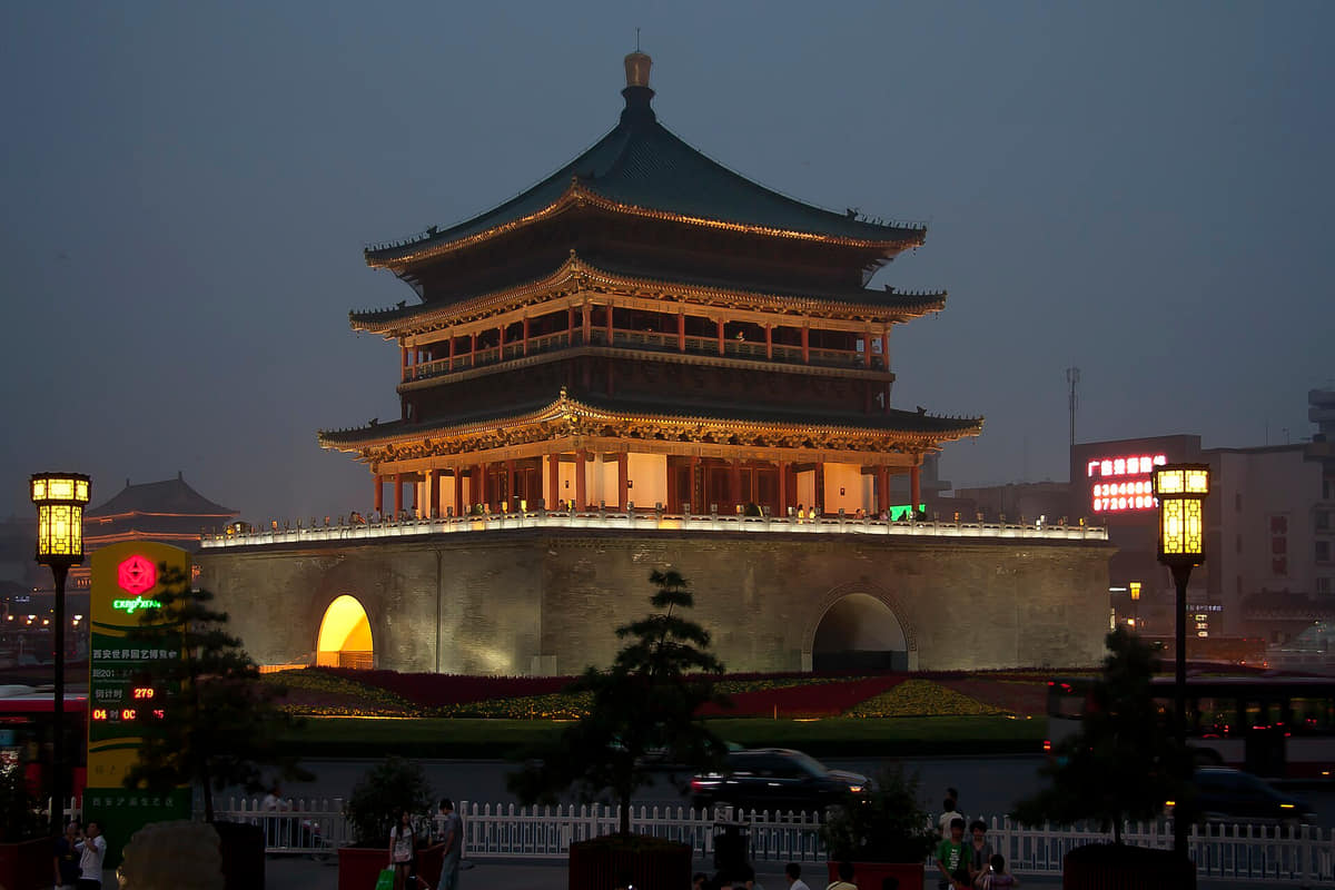
The present wall system and central Bell and Drum Towers make the Ming-period city highly legible. Yet surviving bases, rebuilt superstructures, repeated repairs, roads, parks and tourist facilities belong to different dates. Architectural continuity should not be equated with untouched material authenticity.[9]
Railway construction, schools, publishing, military and civic institutions, migration, war and changing commerce altered Xi'an in uneven ways. Station and wall photographs show infrastructure and form, but political positions, individual experiences and conflict histories require separate, carefully sourced treatment.[9]
Industrial districts, research institutes, universities, new housing and roads expanded beyond the wall. Archaeological work and museums also changed how earlier capitals were known and displayed. Modern expertise, labor, displacement and conservation decisions are part of heritage history.[9][6]
Metro and rail networks, new districts, logistics, housing and visitor economies have enlarged Xi'an's daily geography. Heritage can support research and livelihoods while also producing crowding, staged reconstruction and unequal benefits. Current planning, ecology and community effects need dated, district-level evidence.[6][10]
Eight perspectives describe a 13.2363-million-resident municipality through language, community histories, archaeology, education, industry, food labor, county geographies and unequal access—without assigning one ancient-capital personality to everyone.
The official end-2025 permanent-resident count covers dense central districts, expanding suburban areas, heritage zones, mountain-edge settlements and two counties. A municipal total cannot describe identity, household form, migration history, income or belonging.[6][9]
Standard Mandarin supports citywide communication; Guanzhong varieties and other Sinitic languages shape households and neighborhoods; religious, academic, tourist and migrant settings add further languages. Accent and fluency vary by generation and context.[6][9]
Xi'an's Hui communities are visible through mosques, homes, businesses, food practices and family histories, but a night market is not a complete community portrait. Han residents and people from many other regions and backgrounds also shape the city.[6][9]
Excavators, conservators, registrars, researchers, guides, security staff, cleaners and crafts workers make sites and collections accessible. Their decisions and labor shape what visitors see, while many deposits remain unexcavated or intentionally protected in place.[6][9]
Universities, laboratories, aerospace and manufacturing enterprises, software and service firms employ different communities. High-technology identity should not erase routine production, maintenance, administration, delivery, retail and care work.[6][9]
Grain growers, livestock producers, millers, wholesalers, drivers, cooks, servers, dishwashers, inspectors and delivery riders connect Guanzhong and distant suppliers to city meals. Famous dishes are endpoints of labor, water, energy and regulation.[6][9]
Life inside the wall, around university and industrial districts, in Lintong, along the Qinling edge, and in Lantian or Zhouzhi differs in transport, work, housing, environment and public services. One ‘Xi'an lifestyle’ would hide these spatial differences.[6][9]
Age, disability, income, registration, work schedules, ticket systems, distance and language affect access to transport, schools, care, museums and parks. Popular heritage and food districts may be close on a visitor map but difficult to use for some residents.[6][9]
Fourteen entries place noodles, breads, soups, cold-dressed staples, pastries, condiments and migrant kitchens within technique, community attribution, ingredients, allergens, labor, regulation and the complete food system.
Wide hand-pulled or stretched noodles are associated with Guanzhong, but thickness, fold, oil, chili, vinegar, vegetables and meat vary. The complex written character is a popular cultural sign, not an ingredient list; verify wheat, soy, sesame, peanut and cross-contact.[6]
Baked flatbread is split and filled with chopped braised meat in many forms. Bread style, meat species and cut, braising liquid, fat, salt and size vary; the preparation photograph records labor but not universal recipe, hygiene or nutrition.[6]
Paomo combines torn bread, broth and commonly mutton or beef, with maker-specific spices and service. The national ICH record documents one Laosunjia mutton tradition, not every bowl; confirm meat, gluten, broth, sodium, coriander, chili and halal practice.[14]
Liangpi is a family of cold-dressed sheets or strips made through different rice, wheat or starch processes. Texture, gluten content, sauce, vinegar, garlic, sesame, peanut, chili and bean sprouts vary; appearance alone cannot identify a safe allergen profile.[14][6]
Flatbreads, buns and wheat cakes support sandwiches, soups and standalone snacks. Fermentation, oven or steam, flour, oil, filling and holding temperature differ by stall or household; a steam-filled frame does not establish sanitation.[14][6]
Sour, aromatic broth, diced toppings and thin noodles are associated especially with western Guanzhong and Qishan rather than originating in Xi'an city. Xi'an restaurants make and adapt them; label regional origin, meat, egg, tofu, wheat and vinegar accurately.[14][6]
Common versions combine torn bread with pork intestine and broth, but shops and recipes differ. The name should not obscure offal, pork, gluten, fat, sodium and preparation; it is not suitable for all dietary or religious practices.[14][6]
Soup buns in Xi'an include Muslim and non-Muslim restaurant traditions with different fillings and techniques. Hot liquid can burn; verify meat, broth, wheat, sesame, soy and halal practice rather than using one famous shop to represent every maker.[14][6]
Market versions may combine persimmon pulp and flour around sweet fillings before frying. Fruit variety, flour, sugar, nuts, oil and storage vary; orange color does not prove ingredient proportion, freshness or allergen safety.[14][6]
Traditional branded and household versions use layered pastry and sweet fillings with different oils, nuts, rose, sugar or preserved ingredients. Ask about lard, wheat, nuts, sesame and shelf life; ‘crystal’ describes a valued style, not transparency or low sugar.[14][6]
Dumpling banquets use varied shapes, fillings and service sequences as restaurant performance as well as food. Confirm meat, seafood, egg, wheat, sesame, soy, dyes and cross-contact; presentation should not be mistaken for an ancient unchanged custom.[14][6]
Pickled garlic, chili pastes, vinegar, coriander and other sides change how paomo, noodles and breads are eaten. Sodium, sugar, fermentation, additives and allergens vary; condiments should be documented rather than treated as decorative garnish.[14][6]
Shaanxi county traditions, cuisines from across China and international restaurants all belong to what residents eat. Accurate coverage identifies origin, migration, adaptation, price and labor rather than relabeling every dish as ancient Xi'an food.[14][6]
Farming, livestock, flour milling, wholesale markets, cold chains, water, fuel, kitchens, inspection, affordability, nutrition, delivery, packaging, wastewater and leftovers form the municipal food system. A beautiful dish wall proves neither safety nor sustainability.[14][6]
Balance the visible monuments with museums, active neighborhoods, food, and the larger landscape.
Four focused guides turn the complete city profile into seasonal, itinerary, and food decisions.
Ancient-capital history is visible everywhere, but it shares the city with markets, universities, transit, neighborhoods, and contemporary work.
Read the story