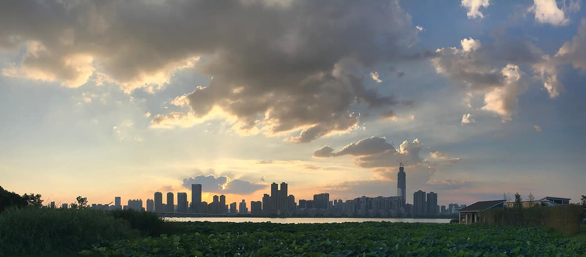
A river-and-lake metropolis where three historic towns, bridges and ferries, universities, industry, provincial institutions, breakfast streets, wetlands, and new centers remain visibly different.
Yangtze–Han confluence, three towns, Yellow Crane Tower, river bridges, East Lake, universities, industry, breakfast culture, and Hubei collections[1][2][3][4]
Guide scope
Thirteen districts spanning Hankou, Wuchang, Hanyang, major lakes, new towns, industrial corridors, wetlands, agriculture, and outer settlements[1][2][3][4]
Understand Wuhan as connected waters and multiple centers
Wuhan is organized by water before it is organized by a skyline. The Yangtze and Han rivers divide and connect Wuchang, Hankou and Hanyang, while lakes, channels, lowlands and embankments shape thirteen districts far beyond the central confluence.
The three towns are not interchangeable labels. Hankou's commercial and port history, Wuchang's administrative and university landscapes, and Hanyang's industrial and religious sites developed on different banks before bridges, ferries, rail, roads and metro systems tightened their links.
Deep history also sits at different scales. Panlongcheng belongs to local archaeology in Huangpi; Hubei Provincial Museum holds objects from many places across the province; Hankou's protected buildings document modern trade; and the 1957 bridge made metropolitan integration physically visible.
A complete guide must therefore move between central streets and outer districts, museums and living practice, famous architecture and ordinary mobility, breakfast counters and wetland forests. Current weather, water level, transport, access and food safety remain live information rather than timeless city facts.
Confluence metropolis
Two rivers, three towns, bridges, ferries, levees, and ports explain urban form.
Lake system
Urban ecology depends on lakes, channels, rainfall, flood storage, restoration, and public access.
Knowledge and industry
Universities, hospitals, research, heavy industry, advanced manufacturing, and services coexist.
Breakfast public life
Morning food connects markets, neighborhood routines, mobility, affordability, and local identity.
A visual record of the city
Twenty-seven locally hosted, rights-cleared images move from the two-river core to East Lake, Huangpi archaeology, Hankou architecture, Hanyang heritage, university and research districts, Wuhan Station, Qingshan and Xinzhou wetland, then into four distinct breakfast contexts and a museum performance. Captions separate visible evidence from provenance, reconstruction, current access, hydrology, recipe claims and endorsement.
The core spans both banks of the Yangtze and the banks of the Han, while the municipality extends through dense lake systems, industrial and research corridors, outer new towns, wetlands, farms, and villages.[1][2][3][4]
Two major rivers, a dense lake network, low alluvial terrain, interior hills, and thirteen districts define Wuhan.
River confluence
The Yangtze and Han rivers divide and connect Wuchang, Hankou, and Hanyang through bridges, ferries, embankments, ports, and wetlands.[1][2][3][4]
Lake network
East Lake and many smaller lakes, channels, lowlands, and reclaimed edges make water management central to metropolitan ecology.[1][2][3][4]
Alluvial plain and hills
Mostly low terrain is interrupted by ridges and hills that shaped settlement, defense, campuses, parks, and views.[1][2][3][4]
Municipal scale
Thirteen districts span the three-town core, lake systems, manufacturing corridors, new towns, agriculture, wetlands, and outer rural landscapes.[1][2][3][4]
Permanent residents across all thirteen districts of Wuhan Municipality; do not mix with the central built-up-area population, 9.6134 million registered residents, students, railway or ferry passengers, visitors, or wider metropolitan estimates
Population figures use the administrative area and source date shown below.[5][7]
Climate
Humid subtropical monsoon climate
Summers are very hot, humid, and rainy; winters are cool and damp, while spring rain and autumn clarity strongly affect river and lake use.
Climate describes long-term seasonal patterns; live conditions appear separately.[8][10]
Seasonal patterns
March–May
Spring
Rapid warming, frequent rain, flowers, and changing river levels make flexible lake and neighborhood plans useful.[1][2][3][4]
June–August
Summer
Very hot humid conditions, heavy rain, and flood risk make shade, hydration, indoor stops, and official weather alerts essential.[1][2][3][4]
September–November
Autumn
Clearer and less humid periods favor river crossings, lake greenways, campuses, museums, and long walks.[1][2][3][4]
December–February
Winter
Cold damp spells can feel sharp; museums, food routes, historic interiors, and short waterfront sections combine well.[1][2][3][4]
A short history of the city
Eleven sourced layers move from river–lake settlement and Panlongcheng through Wuchang, Hanyang and the Han River channel shift, neutral treaty-port and 1911 history, administrative integration, the 1957 bridge, universities and industry, to a contemporary thirteen-district lake metropolis.
Image credits and licenses
Bronze yue from Panlongcheng contextPhoto: Gary Todd from Xinzheng, China · source · CC0
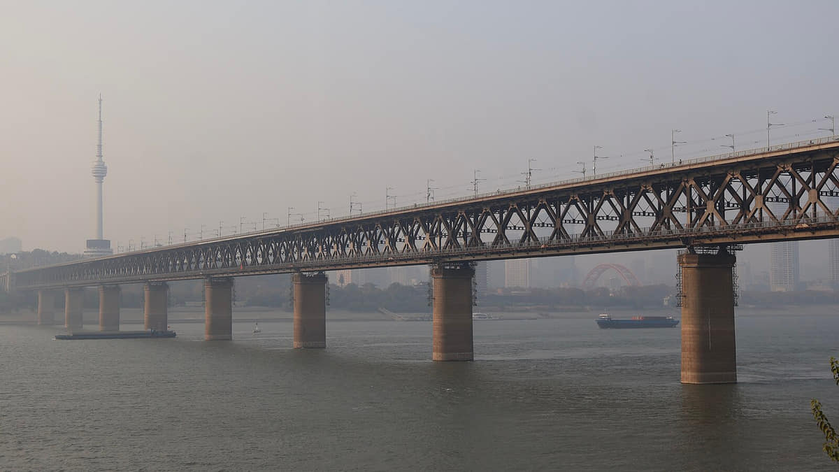
Wuhan Yangtze River BridgePhoto: S5A-0043 · source · CC BY 4.0
Wuchang roofs and the YangtzePhoto: Gary Todd from Xinzheng, China · source · CC0
River–lake settlement
Archaeological and geographical records point to long settlement around waterways, low plains, hills and productive wetlands; this is a regional sequence rather than one continuous modern city.[9][10]
Panlongcheng
The Huangpi site preserves a walled center, palace foundations, high-status burials and workshop evidence associated with early Shang-period networks in the middle Yangtze.[12]
Wuchang and Hanyang
Administrative centers, river crossings, markets, temples, agriculture and craft developed on opposite banks, with names, jurisdictions and urban footprints changing repeatedly.[9]
Han River channel shift
A change in the Han River's main channel helped form Hankou and established the geographic basis of the three-town pattern; hydrology and commerce shaped each other.[9][10]
Hankou treaty port
Customs, shipping, banks, concessions, factories, warehouses and new municipal systems transformed Hankou. The surviving architecture records unequal treaty-port history as well as later reuse.[9][17]
Rail, industry and education
Railways, Hanyang industry, technical institutions, schools and hospitals expanded the urban system beyond river trade alone.[9][18]
Wuchang uprising and its sites
Events beginning in Wuchang became part of the 1911 Revolution. Museums and surviving buildings interpret the event; the guide records chronology and place without political advocacy.[9][18]
Administrative integration
Wuchang, Hankou and Hanyang moved through changing administrative arrangements before the modern municipality and its later district system took shape.[9][7]
First Yangtze bridge
The road-and-rail bridge connected Hanyang and Wuchang and linked major rail corridors, making the three-town metropolis materially different while ferries continued to carry civic memory.[19][34]
Industry, universities and new crossings
Heavy industry, higher education, hospitals, research institutes, highways, more bridges and mass transit diversified work and daily mobility.[6][22]
Polycentric lake metropolis
Metro lines, Wuhan Station, Optics Valley, new residential centers, greenways and ecological projects add new layers, while thirteen districts still retain sharply different landscapes.[5][6][21][36]
People, language, and everyday rhythms
Eight perspectives describe 13.8619 million end-2025 permanent residents through an exact municipality-wide scope, thirteen district settings, three-town routines, students and researchers, mobility, language geography, work and an explicit rejection of one city personality.
Population scope
The end-2025 figure of 13.8619 million is a municipality-wide permanent-resident count, not the population of the central built-up area, registered residents, students, passengers or visitors.[5]
Thirteen district contexts
Historic cores, industrial corridors, university districts, development zones, lake-edge neighborhoods, new towns, farms, villages and wetlands create different daily settings.[7][6]
Three-town routines
Cross-river commutes matter, but Hankou, Wuchang and Hanyang each contain multiple neighborhoods and cannot be reduced to commerce, education or industry alone.[6][9]
Students and researchers
Universities, hospitals, laboratories and technology firms create large, mobile learning and research communities around campuses and southeast lake corridors.[5][22]
River and rail mobility
Ferries, bridges, stations, metro lines, buses and walking routes produce different experiences of distance; a crossing can be commute, work, memory or leisure.[34][19]
Language diversity
Municipal records distinguish Southwestern Mandarin in much of the core, Huang–Xiao speech in the northeast and Gan varieties in southern Jiangxia, alongside widespread Standard Mandarin.[11]
Work and care
Manufacturing, logistics, education, medicine, commerce, food service, construction, technology, farming and public-sector work sustain different schedules and social worlds.[6][5]
Avoiding one personality
Direct speech, heat, breakfast and river crossings are common city images, but nearly fourteen million residents cannot be assigned one temperament, accent or lifestyle.[5][11]
Guiyuan TemplePhoto: Gary Todd from Xinzheng, China · source · CC0
Panlongcheng archaeology
Site, museum, excavation, conservation and public interpretation make a local Bronze Age urban landscape visible in Huangpi.[12]
Provincial collection literacy
Hubei Provincial Museum gathers histories from across the province; visitors should read every label for findspot, date, object history and conservation rather than treating all displays as Wuhan finds.[13][14][15]
Yellow Crane literary memory
Poetry, repeated destruction and reconstruction, garden design, views and city branding overlap, but textual tradition and present architecture are not the same evidence.[20][9]
Han Opera
Vocal systems, role types, repertory, institutions, teachers and audiences form a living stage tradition whose transmission differs from a single tourism performance.[23][25]
Chu Opera
Professional companies, local stages, training and community audiences keep another regional theatrical tradition active in and around Wuhan.[24][26]
Dagu, storytelling and puppetry
Hubei dagu, storytelling, smaller sung forms and puppetry broaden the city's performance landscape beyond the two best-known opera names.[26][11]
Chime-bell interpretation
Ancient bells, archaeological music research, replica instruments and staged music-and-dance are related but distinct layers of evidence and practice.[14][16]
Hankou historic fabric
Customs, banks, warehouses, residences, religious buildings, lanes and later commercial reuse record modern port-city change at building scale.[17][9]
Campus architecture
Protected early Wuhan University buildings, hills, courtyards, libraries and everyday teaching create a knowledge landscape, not merely a seasonal photo setting.[22]
Living religious institutions
Buddhist and other religious sites require respectful distinction among architecture, worship, collections, community use and visitor activity.[6][10]
River public culture
Ferries, embankments, parks, flood marks, bridges, viewing, swimming traditions and daily commuting make water a shared civic space.[34][21]
Contemporary creation
Universities, museums, bookstores, music, design, animation, sports and technology communities add current production to inherited culture without replacing it.[22][25]
Food and local flavor
Fourteen entries treat breakfast as a system rather than one icon: hot-dry noodles, three-fresh doupi, mianwo, shaomei, soup dumplings, beef noodles, fermented-rice foods, lotus-root soup, fish, duck and wetland ingredients, followed by menu-safety guidance. Images are servings, not origin proof or universal recipes.
Alkaline noodles are commonly mixed with sesame-based sauce, oil, preserved vegetables, scallion and shop-specific seasoning; convenient packaged standards and a freshly served bowl are not the same product.[28][32][33]
Griddled rice parcel
Three-fresh doupi
A thin egg-and-starch skin encloses seasoned sticky rice and fillings before browning and cutting; the English word ‘tofu skin’ can mislead because this dish is a composed griddled parcel.[29][30][27]
Fried rice-and-legume batter
Mianwo
A ring-shaped fried breakfast varies in thickness, crispness, sesame and batter ratio; one plated version should not be treated as a citywide standard.[28][31][33]
Steamed wheat wrapper
Shaomei
Wuhan breakfast versions often emphasize peppery glutinous-rice filling, but wrapper, seasoning, fat and portion vary by shop.[28][31]
Filled steamed buns
Soup dumplings
Thin wrappers, meat filling and hot liquid demand careful eating; exact style, broth, meat and lineage claims differ among businesses.[28][31]
Noodle-shop staple
Beef noodles
Broth, beef cut, chili, pickles, noodle texture and portion create many neighborhood variants rather than one municipal formula.[28][31]
Sweet fermented-rice bowl
Paste rice wine
Rice fermentation, starch thickness, osmanthus or other aromas and serving temperature vary; sweetness and alcohol content should be checked directly.[28][33]
Hot breakfast drink
Egg rice wine
Beaten egg and sweet fermented-rice liquid form a quick warm accompaniment; egg handling, sugar and alcohol content matter for individual dietary needs.[28][33]
Slow-cooked household and restaurant soup
Lotus-root rib soup
Lotus root links the table to Hubei wetland agriculture, while pork cut, simmering time, salt and seasonal variety shape each pot.[28][27]
Freshwater fish preparations
Wuchang fish dishes
A historical species name, cultivation and supply chain, a restaurant dish and the city's Wuchang place-name should not be collapsed into one origin story.[28][31]
Contemporary snack and meal category
Duck preparations
Necks, wings, offal and whole-duck dishes use different braises, spices and preservation; strong branding is not evidence of one ancient recipe.[31][27]
Ingredient landscape
Freshwater and wetland table
Fish, shrimp, lotus roots, water vegetables and preserved foods relate to a broad regional water landscape, but present sourcing and sustainability require supplier-level evidence.[10][28]
Public morning routine
Guozao breakfast system
The cultural value lies not in one dish but in small portions, rapid service, neighborhood repetition, commuting and combinations chosen at counters and stalls.[28][33]
Practical food literacy
Reading a menu safely
Ask about sesame, peanuts, wheat, soy, egg, pork, shellfish, alcohol, chili, cooking oil and cross-contact; heritage status never guarantees current food safety or dietary suitability.[27][32]
The primary orientation system: rivers divide and connect Hankou, Wuchang and Hanyang through bridges, ferries, embankments and transit.[6][10]
Yellow Crane Tower
A present reconstruction within a larger park whose literary, visual, garden and tourism layers should be read separately.[20]
Wuhan Yangtze River Bridge
A 1957 road-and-rail crossing that changed metropolitan integration without making ferries or later bridges irrelevant.[19][34]
East Lake and Mount Mo
A lake landscape combining water, hills, greenways, gardens, universities, neighborhoods, research and ecological management.[21][10]
Hubei Provincial Museum
A provincial institution where collection geography must be read object by object rather than equated with Wuhan archaeology.[13][14][15]
Panlongcheng Site Museum
A local archaeological site and museum in Huangpi with walled, palace, burial and workshop evidence from about 3,500 years ago.[12]
Jianghan Customs House Museum
A protected customs building and museum interpreting trade, port institutions and modern urban change in Hankou.[17]
Jianghan Road and Hankou historic blocks
Commercial facades, banks, lanes, residences and later reuse require slow, building-by-building reading.[17][9]
Qingchuan Pavilion
A Hanyang riverside complex of rebuilt and historic layers facing the wider bridge-and-tower landscape.[9][19]
Guqin Terrace
A commemorative garden associated with the Boya–Ziqi story; legend, textual transmission, rebuilt architecture and music practice are different layers.[9]
Guiyuan Temple
A living Buddhist institution in Hanyang whose worship, architecture, collection and visitor uses require respectful separation.[6][10]
Wuhan University early buildings
Protected campus architecture embedded in teaching, research and everyday student life rather than an isolated scenic set.[22]
Tanhualin
A layered Wuchang neighborhood of institutions, residences, religious buildings, lanes and later visitor-oriented adaptation.[9][18]
Wuhan Railway Station
A regional rail interchange whose architecture and forecourt show one contemporary mobility scale; live services require railway sources.[6][5]
Optics Valley corridor
Universities, laboratories, firms, housing and transit form a research and technology landscape rather than one plaza or brand image.[36][22]
Zhangdu Lake wetland
A Xinzhou freshwater wetland and water-forest landscape that makes the municipality's outer lowlands visible.[35]
Wuhan Museum
A municipal museum focused on local archaeology, city history and folk collections, complementary to the province-wide Hubei museum.[18]
Ways to explore the city
Cross water deliberately, compare the three towns, and add a lake and an outer archaeological or industrial site.
Three towns by water
Hankou riverfront → ferry or bridge → Wuchang → Hanyang
Compare commercial, educational-administrative, and industrial histories through real river crossings.[1][2][3][4]
Museum to lake
Hubei Provincial Museum → East Lake greenway
Connect middle-Yangtze collections and ancient music with contemporary lake ecology, universities, and public recreation.[1][2][3][4]
Deep city
Panlongcheng → Hankou heritage → modern bridge
Move from early settlement to port-city streets and twentieth-century metropolitan infrastructure.[1][2][3][4]
Hubei connections
Continue through Hubei
Set Wuhan's river confluence, three-town form and museum collections within a wider Hubei city network.