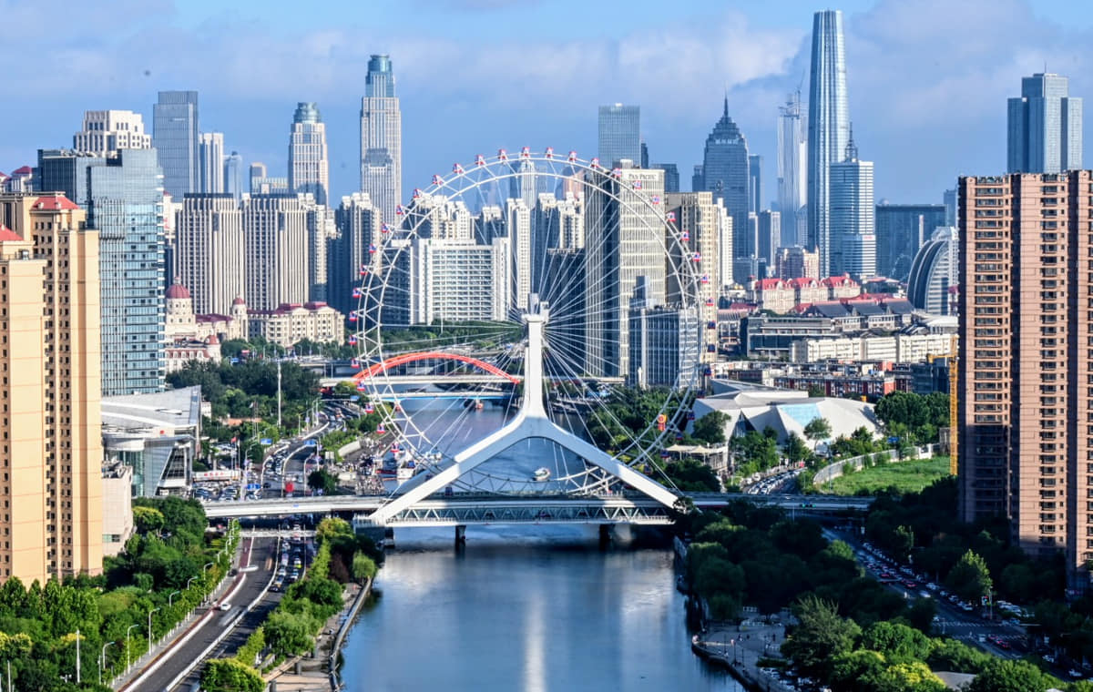
Tianjin is both a city and one of China's four province-level municipalities. Its 16 districts connect the Hai River core, Bohai port, historic neighborhoods, industry, canal towns and the Jizhou hills.
Hai River, port, bridges, concession-era architecture, crafts, and spoken arts[1][2][3][4]
Guide scope
The central river city, 16 districts, Binhai coast, Jizhou hills, and port context[1][2][3][4]
Tianjin, China: how the municipality, river, port and 16 districts connect
Tianjin is a municipality of linked waters and sharply different districts: a dense river city, a Bohai port and industrial coast, canal towns and farmland, and the hills of Jizhou. A complete guide must move beyond the central skyline and treat all 16 districts as parts of one changing urban-region system.
The Hai River and Grand Canal explain why settlement, grain transport, markets, maritime belief and later industry concentrated here. Bridges, railway stations, warehouses and the port are not background infrastructure; they are central evidence for how Tianjin grew and how residents continue to move.
Tianjin's celebrated early-twentieth-century districts emerged through treaty-port and concession systems formed during conflict and unequal treaty relations. Their architecture is valuable evidence, but it should be read alongside colonial institutions, Chinese residents and businesses, later reuse, conservation and today's neighborhood life—not as a nostalgic imported stage set.
Culture is equally material and performed: Yangliuqing printing, painted clay, xiangsheng, temple practice, breakfast stalls, industrial labor, libraries and museums involve different makers, institutions and audiences. Photographs and famous brands are starting points; living practice, access, price, safety and current conditions still require direct verification.
Quick answers
Is Tianjin a city or a province?
Tianjin is a city and one of China's four province-level municipalities. Its 16 districts span the Hai River core, Binhai coast and port, canal towns, farmland and the Jizhou hills.
What is Tianjin known for?
Tianjin is known for the Hai River, its Bohai port, treaty-port and industrial history, Five Great Avenues, Tianjin-style breakfast, xiangsheng and craft traditions such as Yangliuqing prints.
River city
Water, bridges, canals, port routes, and public space form a connected urban system.
Layered architecture
Traditional streets, concession-era districts, industry, and new waterfronts coexist.
Spoken culture
Xiangsheng and other quyi traditions make voice, timing, and audience interaction central.
Coast and municipality
The port, wetlands, hills, and dense center require more than one spatial scale.
A visual record of the city
Twenty-seven locally hosted, rights-cleared records connect the Hai River, historic districts, rail and port infrastructure, Binhai institutions, Yangliuqing craft, Jizhou mountain heritage, live performance and breakfast labor. Captions identify exactly what is visible and separate historic fabric, reconstruction, museum display, living use and dated conditions.
Image credits and licenses
Hai River, bridges and central skylinePhoto: KangTyngrwey · source · CC BY-SA 4.0
The central city sits on the Hai River, while the municipality extends east to Bohai Bay, north toward Jizhou's hills, and across broad lowland districts.[1][2][3][4]
Hot, humid summers contrast with cold, dry winters; spring is windy and most rain falls in summer.
Climate describes long-term seasonal patterns; live conditions appear separately.[1][2][3][4]
Seasonal patterns
March–May
Spring
Dry air, wind, and rapid warming make layers useful; riverfront trees and neighborhood parks become active.[1][2][3][4]
June–August
Summer
Hot, humid weather and concentrated rainfall favor shaded streets, museums, and later waterfront walks.[1][2][3][4]
September–November
Autumn
Lower humidity and clearer days suit long walks through historic districts and along the Hai River.[1][2][3][4]
December–February
Winter
Cold, dry weather, wind, and indoor heating define the season; coastal areas can feel especially exposed.[1][2][3][4]
A short history of the city
Eleven evidence-led layers explain Tianjin through rivers and canals, the 1404 guard city, treaty-port and concession systems, rail and finance, conflict, industrialization, coastal expansion, riverfront renewal and stewardship across 16 districts.
Image credits and licenses
Ancient Culture Street entrancePhoto: William M Benson · source · Public domain
Artillery display at the Taku Fort sitePhoto: KangTyngrwey · source · CC BY 4.0
Rivers, coast and earlier settlements
Low alluvial plains, shifting river courses, the Bohai coast and regional settlements created a transport landscape before Tianjin became a formally fortified city. Archaeology and local records, rather than a single founding date, are needed to understand this longer prehistory.[3]
Canal junction and river markets
Sections of the Grand Canal connected northern political centers with grain regions. At the meeting of waterways, transport, storage, boat repair, markets and settlement became increasingly interdependent.[4]
Tianhou Palace and the Sancha River junction
The official Ancient Culture Street record links the 1326 Tianfei temple to boat communities, exchange and the growth of markets around the river junction. Today's temple precinct contains repeated rebuilding and living religious use, not one untouched medieval layer.[7]
Guard settlement, old city and commercial growth
A fortified guard settlement associated with the name Tianjin was established in 1404. The later old-city grid, gates, water approaches, guild activity and markets developed through changing military, administrative and commercial needs.[3][7]
Treaty port and foreign concessions
After Tianjin became a treaty port, several foreign concessions introduced separate street plans, institutions, policing, finance and architecture under unequal treaty arrangements. This history should include coercion, Chinese communities, commerce and resistance to change—not only stylistic variety.[5][6]
Rail, finance and a commercial metropolis
Rail connections, the Hai River port, banks, hotels, department stores and industrial enterprises tied Tianjin to northern and international networks. Jiefang North Road, the Astor Hotel, Quanyechang and the railway station represent different institutions and dates within that system.[5][3]
Conflict, occupation and social transformation
Wars, foreign military presence, Japanese occupation, labor organization, migration and economic instability repeatedly changed the city. Heritage interpretation should distinguish buildings from the political and human conditions in which they were used.[5]
Industrial municipality
Heavy industry, machinery, chemicals, textiles, port functions, universities and worker housing expanded Tianjin's production base. Industrial growth also carried environmental, occupational and spatial costs that deserve documentation alongside output and engineering achievement.[3]
Port expansion and Binhai growth
Reform-era manufacturing, logistics, development zones and port expansion shifted metropolitan weight toward the coast. Central-city renewal and new infrastructure connected—but did not erase—differences between old neighborhoods, industrial land, villages and new districts.[3]
Riverfront renewal and heritage reuse
Hai River public spaces, bridge lighting, museums and adaptive reuse have made selected urban layers more accessible. Renewal can improve public life while also changing rents, commerce, resident access and the context of protected buildings; those effects require ongoing review.[5][3]
Sixteen districts and layered stewardship
Today the municipality joins protected old-city fabric, the Grand Canal, living temples, coastal wetlands, one of China's largest ports, Jizhou mountain heritage, industrial sites and fast-changing neighborhoods. Stewardship must balance evidence, living use, climate risk, access and economic pressure at different scales.[2][3]
People, language, and everyday rhythms
Eight perspectives describe 13.63 million permanent residents through language, neighborhood routines, port and service labor, education, heritage tourism, district difference and unequal access—without assigning one comic-stage personality to everyone.
A 13.63-million municipality
The 2025 permanent-resident figure covers all 16 districts, from dense central neighborhoods to Binhai, outer plains and Jizhou. It is a municipal total, not the population of the historic center or a description of one lifestyle.[1][2][3]
Language without caricature
Standard Mandarin is widely used, while local Tianjin speech has distinctive phonetic and rhythmic features and a strong public association with comic performance. A performance register should not be treated as how every resident speaks in every setting.[1][2][3]
Riverfront and neighborhood routines
Bridges, parks, residential lanes, markets, transit interchanges and breakfast stalls support different rhythms of public life. Tourist riverfronts are only one part of the everyday city.[1][2][3]
Port, industry and logistics labor
Port operators, factory workers, engineers, drivers, warehouse staff, inspectors and service workers sustain coastal production systems. Promotional skyline images rarely show shift schedules, security boundaries, safety, housing or commuting costs.[1][2][3]
Education, research and services
Universities, hospitals, cultural institutions, finance, retail, technology and public administration create daily networks beyond heavy industry. Students, researchers and service workers use the municipality differently from short-stay visitors.[1][2][3]
Old neighborhoods and heritage tourism
Protected streets remain places of residence, work, worship and small business as well as destinations. Quiet facades can conceal shared courtyards, maintenance constraints, accessibility barriers and changing commercial pressure.[1][2][3]
District difference
Heping and Nankai, Binhai, Xiqing, Jinghai, Ninghe, Baodi, Wuqing and Jizhou contain very different densities, landscapes and livelihoods. No central-city cultural shorthand should stand in for the entire municipality.[1][2][3]
Migration, age and unequal access
Long-term residents, migrants, older people, children and people with disabilities encounter housing, transit, climate, museums and heritage sites differently. Reliable city guidance should state barriers and live conditions instead of assuming universal access.[1][2][3]
Culture and daily life
Image credits and licenses
Yangliuqing New Year picture with domestic vignettesPhoto: Auongkinghe · source · CC BY-SA 4.0
Painted-clay ensemble of women making artPhoto: Auongkinghe · source · CC BY-SA 4.0
Two-person xiangsheng on a small stagePhoto: Rolfmueller · source · CC BY-SA 3.0
Bronze guardian figure at Tianhou PalacePhoto: ermell · source · CC BY-SA 3.0
Entrance to Shi Family Grand CourtyardPhoto: TJArchi-Studio · source · CC BY-SA 2.0
Xiangsheng as performed partnership
Tianjin is an important center for xiangsheng, a live verbal art shaped by timing, role, audience response, repertoire and training. Teahouse intimacy and stage conventions matter, but a famous comic style does not define every resident's personality.[11]
Quyi beyond one genre
Drum songs, storytelling and other spoken-sung forms coexist with xiangsheng. Each has distinct instruments, vocal methods, lineages, venues and safeguarding conditions that should not be collapsed into generic entertainment.[11][14]
Yangliuqing woodblock pictures
The tradition combines drafted design, carved blocks, repeated printing and hand-applied color. Finished images should be connected to paper, pigment, block storage, edition, workshop labor and changing festival demand.[9]
Clay Figurine Zhang
Modeling, observation, drying, surface preparation and color turn clay into individual figures and ensembles. Museum displays preserve objects, while transmission also depends on living makers, teaching, materials and markets.[10]
Mazu, waterways and Tianhou Palace
Tianhou Palace connects river and maritime travel, protection beliefs, markets and Tianjin's early settlement memory. It is a living religious place with rebuilt layers; worship, festival, photography and tourism require respectful distinction.[7]
Speech, writing and city memory
Local speech appears in performance, oral history, literature, media and everyday interaction. Recording vocabulary and sound can preserve memory, but stereotypes about bluntness or humor should not replace evidence about people and context.[11]
Concession-era architecture in context
Five Great Avenues, Jiefang North Road and former concession areas contain valuable urban fabric. Conservation should name the unequal treaty and colonial context, Chinese residence and enterprise, later adaptation and current community use together.[5][6]
Old-city commerce and guild networks
Markets, workshops, religious sites, guilds, transport and food clustered around waterways and the walled city. Reconstructed shopping streets are contemporary gateways to this history, not complete substitutes for archival and archaeological evidence.[7]
Dule Temple as living architecture
Dule Temple joins timber construction, sculpture, repair history, worship and present visitor management. Monumental age should not obscure continuing religious use or the practical work of conservation.[8]
Great Wall landscape
Huangyaguan is a mountain route of walls, passes, watchtowers, repairs, vegetation and visitor movement. Exact masonry phases and current safety conditions require site records rather than picturesque assumptions.[8]
Industrial, rail and port heritage
Factories, warehouses, railway infrastructure, bridges and port systems carry engineering and labor histories. Adaptive reuse can retain structures while changing who enters, what work remains and how environmental burdens are remembered.[3]
Museums, libraries and public culture
Tianjin Museum, Binhai Library and the National Maritime Museum offer different scales of collection, reading, education and civic architecture. Their buildings are not the same as their collections, services or accessibility.[3]
Food and local flavor
Fourteen entries move from breakfast icons to technique, coastal supply chains, county condiments, allergens, dietary respect, labor, traceability and live safety checks.
Image credits and licenses
Jianbing guozi being made at a street stallPhoto: 朱華龍 - Zhu Hua Long · source · CC BY 2.0
Container terminals at the Port of Tianjin in 2011Photo: Arrorro · source · CC BY-SA 3.0
Tianjin breakfast is a network of stalls, neighborhood shops, mills, oil, eggs, sauces, labor and rapid service. Jianbing, guobacai, tofu pudding, tea soup and fried foods vary by maker and district; no single table is universal.
Batter is spread thin on a hot griddle, combined with egg, aromatics, sauce and a crisp fried element, then folded for immediate eating. Flour mix, oil, soy, sesame, wheat, egg, chili and cross-contact require direct confirmation.
Thin mung-bean crepes are cut and softened in savory gravy, then finished with condiments. Despite the translated sound, it is not rice crust; wheat, soy, sesame, coriander, chili and shop-specific sauce should be checked.
Pleated steamed buns are part of a broad Tianjin food world; Goubuli is one famous brand and heritage technique, not the owner of every local bun tradition. Fillings, pork, stock, wheat, soy, sesame and serving size vary.
Strands of dough are seasoned, layered, twisted and fried to create a durable crisp pastry. Exhibition pieces can be dramatically oversized; retail size, fillings, sesame, nuts, wheat, sugar and oil differ by product.
A glutinous-rice exterior and sweet filling are fried for a crisp-soft contrast. Brand history should remain separate from the wider technique; hot oil, sugar, filling, wheat or nut cross-contact and serving temperature need attention.
Fried tofu may be combined with several seafood, meat, mushroom or vegetable ingredients in a savory sauce. The name does not define a fixed eight; soy, shellfish, meat, stock, wheat and recipe must be confirmed with the kitchen.
A quick stir-fry traditionally combines three animal ingredients with aromatics and a glossy sauce, but recipes differ substantially. Diners should ask about organ meat, pork, allergens, alcohol, soy, wheat, oil and doneness.
Grain selection, starter culture, fermentation, aging and blending connect Jinghai's canal town with a national intangible-heritage technique. Brand, age statement, ingredients, acidity and actual production origin should be read from the product, not assumed from the name.
Buns, noodles, pancakes and fried dough reflect northern grain systems and fast urban meals. Wheat and gluten are central; egg, soy, sesame, meat stock, oil and cross-contact vary by preparation.
Buns, cakes, fried pastries, pickles and packaged specialties suit transport, markets and gifting. Portability does not prove ancient origin or quality; production date, storage, labeling, additives and allergen statements matter.
Tianjin's diverse communities require precise questions about pork, lard, alcohol, halal certification, vegetarian stock and shared equipment. Neighborhood reputation, dish name or translation is not a guarantee.
Vendors, millers, farmers, fishers, processors, cooks, cleaners, servers and couriers sustain the city table. Current hygiene, crowding, price, opening hours, ingredient substitution and allergen control must be checked at the venue.
Hai River, bridges and central skylinePhoto: KangTyngrwey · source · CC BY-SA 4.0
One street corner in the Five Great AvenuesPhoto: xiquinhosilva · source · CC BY 2.0
Quanye Department Store in 2019Photo: ScareCriterion12 · source · CC BY-SA 4.0
Atrium of Tianjin Binhai LibraryPhoto: H2v5o68z · source · CC0
Guanyin Pavilion at Dule TemplePhoto: Benny · source · CC BY 2.0
Great Wall route at HuangyaguanPhoto: Ronnie Macdonald from Chelmsford, United Kingdom · source · CC BY 2.0
Hai River and its bridges
A continuous urban corridor linking old settlement, central districts, public space, rail, industry and the route toward the coast. Read each bridge by date, structure and present operation rather than as one timeless skyline.[3]
Jiefang Bridge
A riveted movable steel bridge beside Tianjin Station and former financial streets. Structural history, opening mechanism, traffic and night lighting are distinct layers and live operation must be verified.[5]
Tianjin Eye and Yongle Bridge
A Ferris wheel integrated with river-crossing infrastructure. Views, ticketing, weather limits, accessibility and operating hours are live conditions, not fixed facts in a city profile.[8]
Ancient Culture Street and Tianhou Palace
A commercial heritage district organized around a living Mazu temple and early river-junction settlement memory. Rebuilt shopping frontage and protected religious fabric require separate labels.[7]
Old city and Drum Tower area
The former walled-city grid survives through streets, archaeology, place names, rebuilt landmarks and neighborhood memory more than an intact wall. Maps and archival evidence are essential.[7]
Five Great Avenues
A 191.62-hectare historic district across Heping and Hexi with varied residential architecture and street space formed in the former British concession. Colonial context, later residents and present community use belong in the same account.[6]
Jiefang North Road and Astor Hotel
A corridor of former banks, institutions and hotel architecture tied to treaty-port finance and hospitality. Building exteriors, interiors, collections and current business operations are different evidence.[5]
Former Italian concession area
A planned district whose historic buildings now support residence, offices, hospitality and tourism. Present entertainment facades should not be mistaken for original concession-era fabric or the whole neighborhood.[5]
Quanye Department Store
A major early-twentieth-century commercial building whose facade, department-store history, changing tenants and street life reveal different phases of urban consumption.[5]
Tianjin Museum
A municipal collection and exhibition institution. The modern exterior is only an entrance to archaeology, art, craft and urban-history holdings whose display locations change.[3]
Tianjin Railway Station
A major rail gateway at the Hai River that connects national transport, city transit and the historic center. Timetables, security, accessibility and interchange routes require live information.[3]
Port of Tianjin
A working coastal logistics system of terminals, waterways, cranes, rail, road, customs and labor. It is strategic infrastructure with controlled access, not a conventional sightseeing waterfront.[3]
Taku Fort site
An estuary military-heritage site whose surviving remains, museum interpretation, later displays and transformed Binhai skyline must be distinguished. Visitor photographs alone cannot authenticate artillery.[8]
Tianjin Binhai Library
A contemporary public library known for a dramatic terraced atrium. Architecture, real shelving, circulating collections, study services, crowd management and accessibility are separate questions.[3]
National Maritime Museum
A large coastal museum whose architecture frames collections and interpretation about oceans, science and maritime history. Exterior photographs do not substitute for exhibition evidence.[3]
Yangliuqing and Shi Family Grand Courtyard
A Xiqing town landscape linking canal commerce, courtyard architecture, New Year-print traditions and current tourism. Modern gateways, preserved compounds and living workshops should be labeled separately.[9][8]
Dule Temple and Huangyaguan
Two Jizhou anchors that restore northern mountain geography to the municipal guide: a living Buddhist architectural complex and a repaired Great Wall route. Weather, terrain, worship and access differ sharply from central Tianjin.[8]
Ways to explore the city
Use water, architecture, and municipal scale as three complementary ways to explore Tianjin.
Read the river
Tianjin Eye → bridges → central waterfront
Follow infrastructure, public space, skyline change, and night-time use along the Hai River.[1][2][3][4]
Architecture and everyday craft
Five Great Avenues → old city → Ancient Culture Street
Compare concession-era residences with markets, temples, prints, clay figures, and local snacks.[1][2][3][4]
From city to coast
Tianjin Museum → Binhai waterfront → port context
Move from municipal history to the coastal scale that still shapes logistics, industry, and wetlands.[1][2][3][4]
Planning collection
Plan a first visit to Tianjin
Four focused guides turn the complete city profile into seasonal, itinerary, and food decisions.