
Is Shanghai a city or a province?
Shanghai is a provincial-level municipality directly under China's central government. This guide covers the full municipality and all 16 districts, not only the central skyline.[1][2][3][4][5]
Shanghai Municipality · East China
A port metropolis where waterfronts, lane neighborhoods, regional migration, and modern industry meet at several urban scales.
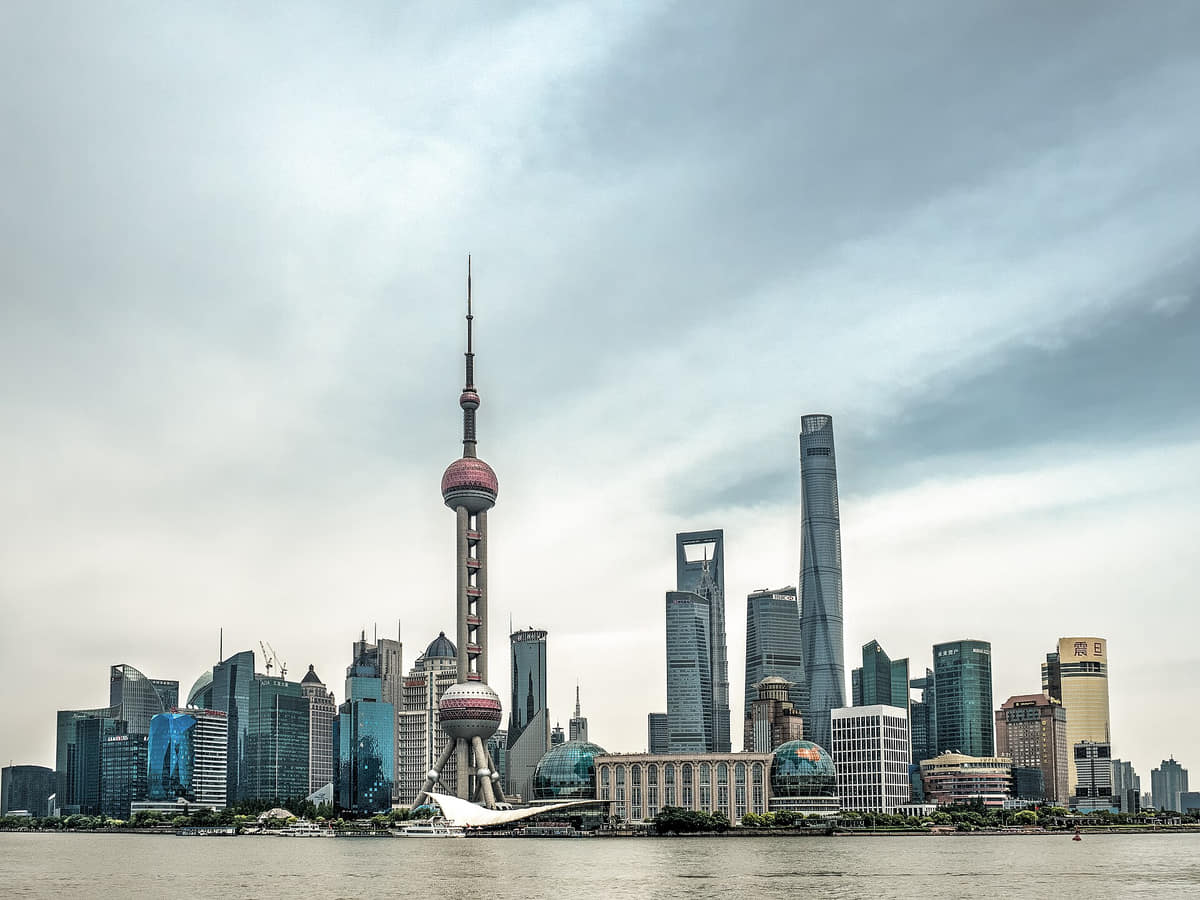
Shanghai is a municipality of 16 districts in the Yangtze River Delta. The official 2025 bulletin records 24.8541 million permanent residents at year end, including 15.1091 million registered permanent residents and 9.7450 million non-local permanent residents. Those figures cover dense central districts, suburban towns, industrial and agricultural land, coast, islands and Chongming—not only the familiar skyline.
Water organizes the municipality. The Huangpu divides and connects central districts; Suzhou Creek, canals and town rivers retain different histories of movement and settlement; the Yangtze estuary and Chongming add tidal, island and coastal scales. Ferries, bridges, tunnels, embankments, drainage, ports and public waterfronts are related systems, not interchangeable scenery.
Shanghai's history is layered rather than linear: archaeological settlements and Jiangnan market towns; county administration and hydraulic works; the treaty-port period, foreign settlements, Chinese commerce and mass migration; industrial production and lilong housing; later metropolitan restructuring; Pudong's post-1990 expansion; and current conservation and adaptive reuse. Each layer affected different people and places unevenly.
Climate and live conditions must be separated. Long-term descriptions indicate four distinct seasons, hot humid summers, a plum-rain period and cool damp winters, while typhoons, intense rain, heat, river levels, air quality, ferry service and venue access vary by date and location. This edition provides context; current forecasts, warnings and operator notices remain authoritative for decisions.
[1][2][3][4][5]Shanghai is a provincial-level municipality directly under China's central government. This guide covers the full municipality and all 16 districts, not only the central skyline.[1][2][3][4][5]
Shanghai occupies a low-lying part of the Yangtze River Delta around the Huangpu River and Yangtze estuary. Its flat terrain, coast, islands, wetlands, and waterways shape the port, urban expansion, and water management.[1][2][3][4][5]
The Huangpu and the wider delta help explain commerce, industry, and outward connections.
Dense residential fabrics reveal domestic life and neighborhood-scale change.
Buildings record changing technologies, institutions, and international exchange.
Metro lines, ferries, walking, and cycling connect distinct urban worlds.
Twenty-five locally hosted, rights-cleared visual records move from the Huangpu skyline and living neighborhoods to gardens, religious and civic places, outer-district towns, industrial reuse, performance, craft and food. Captions state what is visible, what the source identifies, what is dated and what still needs current, institutional, archaeological, environmental or maker-level evidence.
Shanghai lies in the Yangtze River Delta. The municipal boundary includes the dense central city, suburban districts, river systems, coast, and Chongming Island.[1][2][3][4][5]
Low-lying delta geography, the Huangpu River, the Yangtze estuary, canals, and coast explain Shanghai's port functions and continuing water management.
Most of the municipality is flat and densely connected by waterways, roads, rail, and metro lines.[1][2][3][4][5]
The river divides major urban areas while ferries, bridges, tunnels, and waterfront spaces repeatedly reconnect them.[1][2][3][4][5]
The Yangtze estuary, port zones, reclaimed land, wetlands, and islands belong to the wider Shanghai story.[1][2][3][4][5]
Population figures cover 16 districts, from the central city to Chongming and outer suburban areas.[1][2][3][4][5]
Loading current conditions…
Forecast data: Open-MeteoPermanent residents across Shanghai Municipality
Population figures use the administrative area and source date shown below.[6]Shanghai has four seasons, humid hot summers, a plum-rain period, and cool damp winters. Typhoons and intense rain can affect the warmer months.
Climate describes long-term seasonal patterns; live conditions appear separately.[1][2][3][4][5]Temperatures rise unevenly; rain and humidity increase, while parks and neighborhood walks become more comfortable.[1][2][3][4][5]
The plum-rain period is followed by sustained heat and humidity; thunderstorms and typhoons can disrupt plans.[1][2][3][4][5]
Humidity and heat usually decline, creating good conditions for waterfront and neighborhood walking.[1][2][3][4][5]
Temperatures are cool rather than northern-China cold, but moisture and limited indoor heating can produce a damp chill.[1][2][3][4][5]
Eleven sourced layers connect archaeology, Jiangnan settlements, water engineering, the old city, treaty-port institutions, lilong housing, industry, metropolitan restructuring, Pudong growth and current conservation without reducing Shanghai to a village-to-skyline myth.
Guangfulin and other sites place the Shanghai region within a long history of settlement, farming, water adaptation and material culture. The gallery photograph only records the modern site edge; chronology and finds must come from excavation reports and museums.[2]
Before modern central Shanghai became dominant, market towns, fields, canals, temples, bridges and county institutions formed a connected delta landscape. Zhujiajiao, Fengjing, Jiading and Songjiang retain different fragments; none should stand for every town or period.[7][15]
A water-gate ruin discovered in 2001 and preserved below a museum in Putuo is identified by the official record as a Yuan structure linked to the Wusong River. Piles, stonework and iron tenons show that urban history also depends on maintenance and water control, not only buildings above ground.[10]
Garden design, temples, streets, commerce and residences accumulated within the Chinese city. Yu Garden is a major surviving interpretive focus, but the surrounding old city has experienced repeated rebuilding; a composed garden view should not erase housing, labor or later commercial transformation.[2]
After the port opened to foreign trade under treaty arrangements, foreign settlements, Chinese-administered areas, shipping, banking, industry, publishing and migration reshaped the city. Growth produced new opportunities and infrastructure alongside legal inequality, crowding, labor exploitation and uneven security.[2]
Commercial buildings, docks, warehouses, factories, utilities and crossings concentrated along the Huangpu and Suzhou Creek. The Bund and Waibaidu Bridge make parts of this system visible, but architecture alone cannot explain finance, colonial administration, Chinese enterprise, dock labor or household survival.[2][11]
Shikumen and other lilong types combined row housing, narrow lanes, commercial edges and changing household arrangements. Their history includes landlordism, subdivision, migration, service work and resident adaptation; heritage value should be considered together with safety, comfort, tenure and privacy.[3]
Factories and utilities expanded across Yangpu, Hongkou, Zhabei and other districts while publishing, cinema, theatre and education grew in central areas. Industrial imagery should include workers, housing, pollution and logistics—not romanticize chimneys or reduce the era to elegant façades.[11][12]
Industrial production, new residential districts, public institutions, transport and repeated policy shifts changed work and domestic life. Later deindustrialization and river remediation created new public landscapes while raising questions about displaced work, environmental evidence, memory and who benefits from redevelopment.[2][11]
Pudong's high-rise districts, bridges and tunnels, metro construction, port and logistics growth, housing development and suburban urbanization altered Shanghai's scale. A skyline is evidence of built form, not by itself proof of residents' incomes, access, ecological performance or quality of life.[6][2]
The 2026 town-conservation regulation emphasizes waterways, bridges, historic fabric, public services, resident rights and control of excessive commercialization. Dated reuse projects show warehouses and industrial sites taking cultural roles, but present tenants, access, conservation quality and community effects need place-specific review.[8][11]
Eight perspectives describe a 24.8541-million-resident municipality through language, care, infrastructure, research, culture, food labor and unequal access without assigning one cosmopolitan personality to everyone.
The end-2025 count of 24.8541 million includes 15.1091 million registered permanent residents and 9.7450 million non-local permanent residents. Registration categories do not describe identity, length of residence, household form, legal experience or belonging, and international residents are not a single group.[6][2]
Standard Mandarin supports citywide communication; Shanghainese belongs to the Wu language family; other Sinitic varieties and many international languages travel through households, schools, workplaces and media. Fluency, accent and language choice vary by generation and context.[6][2]
Residents, cleaners, couriers, security workers, shopkeepers, caregivers, health staff, teachers and volunteers keep lilong lanes, apartment compounds and suburban communities functioning. Architecture photographs rarely make this daily labor visible.[6][2]
Ferry crews, dock and logistics workers, engineers, maintenance teams, manufacturers and environmental staff connect the metropolitan economy to water and infrastructure. A skyline or heritage factory cannot substitute for workplace, safety or labor evidence.[6][2]
Finance, professional services, universities, laboratories, technology and design are prominent but unevenly distributed. Occupation does not determine lifestyle, and high-value sectors coexist with routine administrative, service and support work.[6][2]
Performers, librarians, museum staff, conservators, craftspeople, archivists, stage crews and community historians produce public culture. Their work includes research, maintenance, teaching, administration and access—not only visible performances or finished objects.[6][2]
Farmers, fishers, wholesalers, processors, drivers, market vendors, cooks, servers, dishwashers, inspectors and delivery riders connect outer districts and distant sources to daily meals. Famous dishes are endpoints of a much larger labor system.[6][2]
Housing cost, tenure, registration, age, disability, income, work schedules and distance affect access to transit, schools, care, parks and cultural venues. Central-city heritage, new Pudong districts, industrial suburbs, water towns and Chongming should not be collapsed into one lifestyle.[6][2]
Fourteen entries place steamed and fried snacks, braising, seasonal crab, home cooking, migration and the complete food system within technique, sourcing, labor, allergens, safety and maker variation.
Thin dough encloses filling and liquid that becomes hot broth during steaming. Pleating, sealing, gelatin or stock, filling, steaming and service vary; confirm meat or shellfish, gluten, sesame, soy, temperature and cross-contact rather than treating the name as an ingredient list.[16]
Buns cook against an oiled pan before or while steam finishes the upper dough. Crispness, fermentation, filling, broth, sesame and scallion vary by maker; hot liquid can burn, and pork, gluten, sesame, soy or other allergens require direct confirmation.[16][2]
A seemingly simple bowl depends on how scallion is fried, the oil and soy seasoning, noodle thickness, cooking time and mixing. Recipes may contain wheat, soy, sugar, animal products or additional aromatics; appearance does not establish a vegetarian or allergen-free dish.[16][2]
Pork is commonly cooked with soy, sugar, wine and aromatics until sauce and fat change texture. Cut, blanching, sweetness, salt, alcohol retention and serving size vary; the glossy gallery image is a serving record, not a standard recipe or nutrition claim.[16][2]
Pork and rice-cake slices are combined with sauce in several restaurant and snack forms. Meat cut, tenderizing, coating, frying oil and rice-cake texture vary; verify wheat, soy, egg, cooking oil, portion and cross-contact at the actual vendor.[16][2]
Mitten crab is associated with cool-season dining and regional supply networks, but menu names can conceal different waters, farms and grades. Confirm species, legal source, season, freshness, storage, preparation, shellfish allergy and advisories; a plated crab photograph proves none of these.[16][2]
Shanghai-style xunyu is often fried fish seasoned in a dark sweet-savory liquid rather than cold-smoked fish. Species, bones, frying oil, sugar, soy and serving temperature vary; translation should describe the actual technique and allergen risks rather than imply one universal method.[16][2]
Texture depends on bird, poaching temperature, resting and chopping, while dips vary. Pale or pink tones cannot by themselves diagnose doneness or safety; food businesses must manage time and temperature, and diners should ask about poultry, sesame, soy and cross-contact.[16][2]
A molded fritter commonly combines batter with shredded radish or other filling before deep-frying. Flour, seasoning, filling, oil age, gluten, egg and cross-contact differ by stall; nostalgia does not establish current hygiene or nutrition.[16][2]
Glutinous or mixed rice can wrap fried dough, pickles, pork floss, sugar or newer fillings. Texture, portion, sodium, sugar, meat, gluten, sesame and oil vary widely; the name describes a format rather than one fixed breakfast.[16][2]
Soy, sugar, wine, oil, stock and seasonal ingredients can create the deep colors often associated with benbang cooking, but home and restaurant versions differ. Reducing Shanghai food to sweetness erases savory, fresh, pickled, steamed and lightly cooked practices.[16][2]
Leafy greens, bamboo shoots, beans, aquatic vegetables, fungi, tofu products and preserved ingredients connect markets and home kitchens to seasons. Species, growing conditions, processing, sodium, storage and household recipes require specific evidence.[16][2]
Regional Chinese cuisines and international restaurants are part of what residents eat today. Accurate coverage should identify origin communities, adaptation, translation, price and labor rather than relabel every dish as Shanghai food or treat imported cuisines as decoration.[16][2]
Agriculture, aquaculture, distant suppliers, wholesale markets, cold chains, water, energy, kitchens, inspection, affordability, nutrition, delivery, packaging, wastewater and leftovers form the city's food system. A dish gallery is an entry point, not proof of safety, sustainability or equitable access.[16][2]
Use the river, lanes, and transit network to connect Shanghai's different historical and social scales.
Four focused guides turn the complete city profile into seasonal, itinerary, and food decisions.
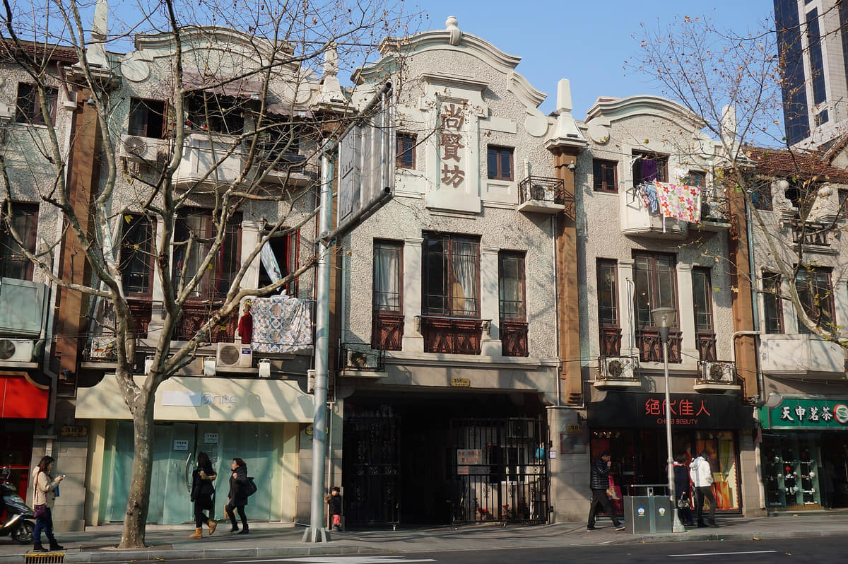
The city’s identity is formed as much by lane neighborhoods, markets, transit, and river crossings as by its most recognizable towers.
Read the story