Vertical circulation
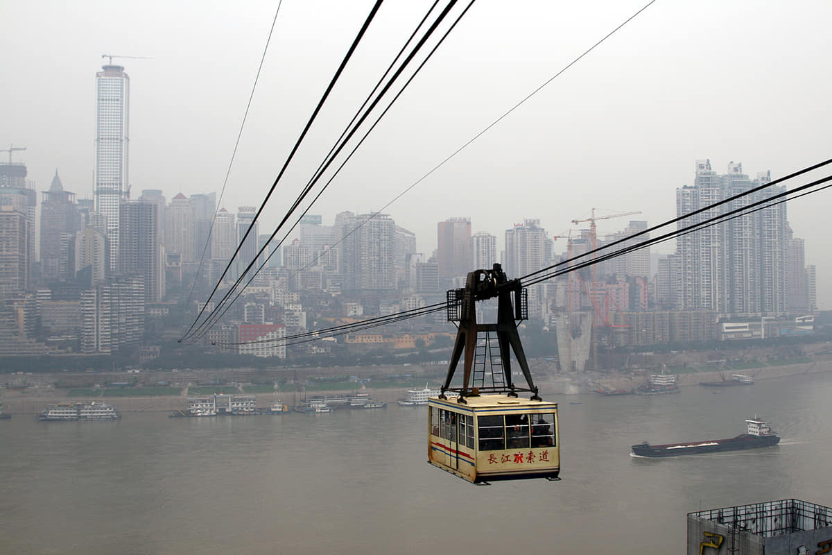
Topography turns stairs, lifts, rail, bridges, tunnels, and building entrances into a connected urban system.
Chongqing Municipality · Southwest China
A vast mountain-river municipality where the celebrated vertical core is only one layer among 37 current districts and counties, Three Gorges landscapes, industry, living heritage, distinct food systems and many everyday Chongqings.

Chongqing is a municipality at provincial administrative level, not a single continuous downtown. Its current 37 county-level units—25 districts, 8 counties and 4 autonomous counties—stretch from the western basin and two-river core to reservoir shores, eastern gorges and southeastern Wuling Mountain communities. The 2025 adjustment created Liangjiang New Area, abolished Jiangbei and Yubei districts, and transferred five former Yubei towns to Beibei; maps and labels on this guide follow the post-adjustment structure.
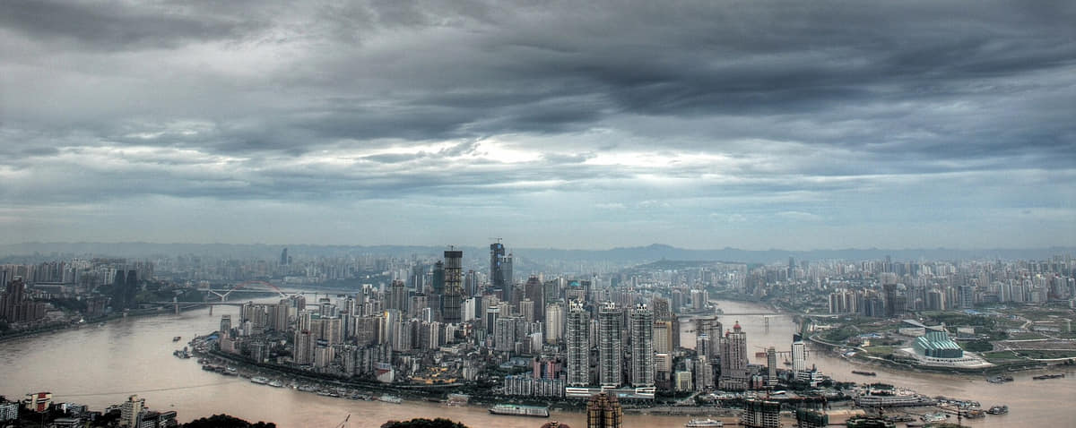
The famous vertical city is real but geographically narrow. Yuzhong and adjacent central districts compress ridges, rivers, bridges, rail, lifts, tunnels and layered streets, while Wanzhou, Fuling, Qianjiang, Wushan, Fengjie, Youyang, Rongchang and many other places have their own settlement patterns, economies, food systems and cultural institutions.
A humid subtropical monsoon climate meets strong elevation and east–west variation. Hot humid summers, damp cloudy winters, fog, heavy rain, flood risk, heat, landslides and mountain weather are durable planning themes, but any day's temperature, river level, visibility, trail access and transport operation require live official checks.
This guide separates what a photograph visibly documents from what sources establish. A museum display is not archaeological provenance; a rebuilt district is not untouched fabric; one stage role is not an entire tradition; one dish is not a canonical recipe; and a dated skyline, ferry, road or gorge view is not current access information.
Topography turns stairs, lifts, rail, bridges, tunnels, and building entrances into a connected urban system.
The Yangtze and Jialing explain port history, industry, flood management, skyline, bridges, and public space.
Thirty-seven current county-level units make administrative scale essential to any complete account.
Museums, carvings, craft, food, performance, neighborhoods, and conservation connect history with present use.
Twenty-seven locally hosted, rights-cleared images build Chongqing at several scales: the two-river core, bridges, cableway, rail and layered streets; protected and reconstructed historic places; museum, industrial and performance interpretation; Dazu, Wulong, Baiheliang, Diaoyu, Qutang and Wushan beyond the core; and five specific food views. Captions state exactly what each frame can and cannot support.
The central reference point sits near the two-river core, but the municipality reaches through western basin districts, the Three Gorges reservoir corridor, eastern mountains and southeastern Wuling landscapes. A single coordinate cannot locate the whole city.[1][2][3][4]
Two major rivers, parallel ridges, tributary valleys, karst, reservoir shores, and 37 current county-level units define Chongqing.
The Yangtze and Jialing rivers meet at the central peninsula, organizing bridges, slopes, ports, views, and movement.[1][2][3][4]
Parallel ridges, steep banks, tributary valleys, tunnels, and changing elevations produce a strongly three-dimensional urban form.[1][2][3][4]
The municipality extends far beyond the core through reservoir shores, karst, mountains, farms, county seats, and river towns.[1][2][3][4]
Twenty-five districts, eight counties and four autonomous counties require a guide that distinguishes the metropolitan core from eastern and southeastern landscapes.[1][2][3][4]
Loading current conditions…
Forecast data: Open-MeteoPermanent residents across Chongqing Municipality as a whole; the current administrative reference is the post-November-2025 structure of 25 districts, 8 counties and 4 autonomous counties, and this total must not be mixed with the central built-up area, former Jiangbei or Yubei districts, current Liangjiang New Area, registered residents, commuters, students, visitors, tourists or daily transport users
Population figures use the administrative area and source date shown below.[5][7][6]Summers are long, hot, humid, and often still; winters are damp and cool, with frequent cloud, fog, and rainfall shaped by basin and mountain terrain.
Climate describes long-term seasonal patterns; live conditions appear separately.[8][9][35]Mild-to-warm weather, fog, and frequent rain make layered clothing and clear-weather viewpoints useful.[1][2][3][4]
Heat, humidity, thunderstorms, and intense sun require shade, hydration, and caution on long stair routes.[1][2][3][4]
Shorter dry and clear periods favor river crossings, outer-district landscapes, and evening walks.[1][2][3][4]
Damp cool conditions, low cloud, and limited indoor heating make warm layers and museum routes practical.[1][2][3][4]
Eleven sourced layers move from physical geography and archaeology through river administration, heritage, migration, port and wartime change, industry, metropolitan growth and today's post-adjustment municipal map.
The Yangtze, Jialing, Wujiang and many tributaries cut folded mountain systems, basin edges and limestone terrain. These processes created the central confluence, parallel ridges, Wulong and Jinfoshan karst, Qutang and Wu gorges, ferry points, flood exposure and very different settlement zones.[9][16]
Archaeological sites and museum collections document long human occupation in the wider Three Gorges and Chongqing region. Exact date, culture, material and findspot belong to excavation and catalogue records; the current municipality cannot be projected unchanged into prehistory.[13][10]
Ba is an important regional historical frame visible in archaeology, bronze objects, place names and later writing. It was not a timeless ethnic or administrative unit identical to today's Chongqing, and its boundaries and centres changed across periods.[13][10]
County and prefectural seats, walls, temples, markets, salt production, ferries, tributary routes, farming and mountain passes connected the upper Yangtze. Names, jurisdictions and functions shifted repeatedly across a territory far larger than the central peninsula.[10][11]
Dazu's ninth–thirteenth-century carving clusters and Diaoyu's mountain-river fortifications illuminate different religious, artistic, social, patronage and military histories. They are separate distributed sites with distinct conservation and archaeological records.[15][23]
Migration, merchant associations, guild halls, temples, docks, markets, boat routes and rebuilding reshaped Chongqing and outer towns. Huguang Guild Hall offers a specific architectural record; it should not be used as a complete story for every migrant household.[17][11]
Treaty-port institutions, steam navigation, customs, banks, schools, workshops, factories and new streets changed the river city after 1891. Industrial heritage preserves material evidence, while opening to foreign trade also involved unequal structures and should not be reduced to a celebratory modernization tale.[10][12]
Government offices, factories, universities, cultural institutions, foreign missions and large migrant populations moved to Chongqing during the war against Japan. Bombing, casualties, displacement, shelter construction and wartime production are essential parts of the record alongside institutional growth.[10][13]
Heavy industry, machinery, chemicals, transport, worker housing, bridges and public institutions expanded through several national development phases. The Great Hall and industrial sites are visible evidence, but labour conditions and neighborhood change require archives and oral history.[12][21]
The 1997 municipality combined the former Chongqing city with wider eastern territories. Bridges, expressways, rail, reservoir-related change, logistics, manufacturing, services, conservation and tourism developed unevenly across central districts, western cities, reservoir shores and mountain counties.[10][9]
Jiangbei and Yubei districts were abolished, Liangjiang New Area became a district, five former Yubei towns moved to Beibei, and parts of former Beibei entered Liangjiang. Current maps must use 37 units, while older statistics, addresses, archives and image captions may legitimately retain former names with dates.[6][7]
Eight perspectives keep population scope, place, language, ethnicity, work, migration, terrain, access and individual variation visible across the whole municipality.
The official end-2025 permanent-resident total is 31.8726 million for the whole municipality. It is not the population of the central built-up area, Yuzhong Peninsula, current Liangjiang New Area, registered residents, commuters, students, tourists or daily transport users.[5][7]
Dense central neighborhoods, western manufacturing cities, reservoir shores, county seats, farms, river ports, tourism towns and southeastern mountain communities have different housing, work, mobility, services and rhythms.[9][7]
Standard Mandarin is widely used; local speech belongs broadly to Southwestern Mandarin, with substantial variation across age, household, district, county, migration and education. Tujia, Miao and other language practices require place- and speaker-specific evidence.[7][13]
Shizhu, Xiushan, Youyang and Pengshui are autonomous counties with diverse Tujia, Miao, Han and other residents. Festival costumes, staged dances or museum displays must never stand in for every community's present life, belief, language or identity.[30][7]
Shipping, manufacturing, construction, retail, food service, logistics, education, health care, tourism, agriculture, craft, digital work and public service connect the municipality. Historic boat songs document one labour system, not today's complete workforce.[12][26][5]
Study, work, marriage, reservoir-related relocation, rural–urban movement, interprovincial migration, return migration, ageing and multigenerational households shape residence. Aggregate population cannot reveal individual mobility or attachment.[5][13]
Stairs, heat, humidity, rain, fog, landslide risk, lifts, rail, ferries, buses, road distance, disability, age and income affect daily access differently. The celebrated vertical city can be demanding rather than playful for many people.[8][35][9]
Hotpot, direct speech, hills and nightlife are visible motifs, not a personality test for more than 31 million people. Temperament varies by person, family, profession, generation, place and circumstance.[5][7]
Fourteen entries move from famous dishes to district systems, fermentation, labour rhythms and evidence limits, with no restaurant endorsement and no claim of one canonical Chongqing recipe.
Broth may use beef tallow or other oils, chiles, peppercorn and aromatics; sliced meat, offal, vegetables, soy products and dipping sauces vary. Shop, household, religious, health, allergy and dietary contexts matter.[31][33]
Fresh alkaline noodles and greens meet a bowl pre-seasoned with soy, chile oil, peppercorn, garlic, ginger, preserved vegetables, peanuts, sesame or other condiments; broth and toppings remain optional and shop-specific.[32][31]
Chongqing-style versions combine blood curd with offal, meat, vegetables, bean sprouts, chile oil and spices in many proportions. Ingredient identity, cooking temperature and safe handling require direct confirmation.[31]
Small fried chicken pieces, dried chiles, peppercorn and aromatics produce a dry, fragrant dish with many restaurant variants. A generic image cannot establish Chongqing venue or canonical origin.[31]
Strong-flavoured fish, chicken, rabbit, offal, pickles and aromatics circulate through informal restaurants, roadside places and urban food districts. The category is porous and changes with fashion, chefs and local naming.[31][33]
Agriculture, salting, pressing, fermentation, slicing, seasoning, packaging and household use form a larger system than one brand. Raw-material origin, additives, sodium and current producer claims require label-level checks.[31][33]
Split fish is grilled and then served with sauce, chiles, vegetables and table heating in many shop styles. Species, source, seasoning, portion, bones, allergens and geographic claim need venue-level evidence.[31][33]
Chicken offal, pickled chiles, vegetables and a hot serving vessel are common motifs, while cuts, sourness, spice and preparation vary. It belongs to Qianjiang context and should not be presented as one universal municipal recipe.[31][33]
Soft-set soy products, stone grinding, coagulants, dipping sauces, fish and local water traditions produce many district forms, including Dianjiang and Beibei references. Texture and terminology are not identical everywhere.[31][33]
Yangtze, Jialing, Wujiang, tributaries and reservoir shores shape fish dishes, vegetables and market routes, but catch origin, aquaculture, closed seasons, ecology and legality must be verified at the time of purchase.[33][9]
Braised poultry, rice, preserved vegetables, pork, freshwater fish and market snacks show western-district food systems. Current shops and names should not erase household, rural or neighbouring Sichuan continuities.[31][33]
Pickled vegetables, chile pastes, fermented beans, cured meat and preserved mustard extend seasonal ingredients and concentrate flavour. Salt, microbes, storage, allergens and industrial versus household processes require separate treatment.[31][32]
Late-opening hotpot, noodles, barbecue and small restaurants reflect shift work, heat avoidance, transport, tourism, delivery platforms and social gatherings. Nightlife differs sharply by district, season, income and personal preference.[33][5]
A photograph can show colour, cut, vessel and visible ingredients. It cannot prove recipe, origin, freshness, allergens, hygiene, ethics, dietary suitability, price or restaurant quality; current labels and inspection information take priority.[31][35]

First decode vertical movement and the two rivers, then pair the central city with at least one outer district or county landscape.

Ridges, rivers, retaining walls, bridges, lifts, rail, and buildings turn elevation into daily urban navigation.
Read the story