Shijiazhuang, China, is Hebei's railway-built capital and a 22-unit municipality linking the North China Plain and Hutuo River with Zhengding, Zhaozhou Bridge and the Taihang Mountains.
Railway-city growth, Hebei Museum, Zhengding, Zhaozhou Bridge, and the Taihang edge[1][2][3][4]
Guide scope
The modern central city plus 22 reviewed county-level units, including Xinji in the official city overview and population scope[1][2][3][4]
Understand Shijiazhuang through Hebei's capital, railway growth and its 22-unit municipality
Shijiazhuang must be read at two historical speeds. The compact provincial capital expanded rapidly around intersecting railways in the twentieth century, while the municipality contains older centers and landscapes—Zhengding, Zhao County, Jingxing, Pingshan, the Hutuo River and the Taihang edge—whose histories cannot be reduced to the age of the central city.
The reviewed municipal listing covers 22 county-level units—eight districts, eleven counties and three county-level cities—across about 15,800 square kilometres. The 2025 statistical bulletin reports 11.2469 million permanent residents and explicitly notes that this population indicator includes Xinji; that statistical scope is broader than the continuously built-up core.
Geography changes from the North China Plain to western Taihang terrain. The Hutuo River, reservoirs, agricultural land, county towns, mountain routes and dense districts create different climates, livelihoods and travel conditions, so a central-city photograph or forecast never describes the whole municipality.
This guide treats monuments, living religious sites, archaeological displays, industrial facades, reconstructions and food visualizations as different evidence. Dates, visible subjects and limitations are stated so that attractive images do not become unsupported claims about originality, current conditions, belief, recipes or every resident's way of life.
Quick answers
Where is Shijiazhuang, China?
Shijiazhuang is the capital of Hebei Province, southwest of Beijing on the North China Plain. Its 22 county-level units extend from the Hutuo River and central railway city to historic Zhengding and the Taihang foothills.
What is Shijiazhuang known for?
Shijiazhuang is known for rapid railway-era growth, while the wider municipality includes Zhengding's monuments, Zhaozhou Bridge, Pingshan archaeology, Taihang routes, industry, agriculture and county food traditions.
Railway capital
Modern growth followed transport intersections, industry, administration, and migration.
Historic counties
Zhengding, Zhao County, Pingshan, and Jingxing hold histories older than the central city.
Plain to Taihang
A wide municipality connects dense urban districts with river plains and western mountains.
Provincial collections
Museums help connect local places with the larger archaeological and artistic record of Hebei.
A visual record of the city
Twenty-seven locally hosted, rights-cleared images connect railway growth, the Hutuo River, Zhengding's monuments, Zhao County engineering, Pingshan archaeology, Taihang temples, museums, industry, public life and two clearly labelled food reconstructions. Every caption separates visible evidence from restoration, reconstruction, museum display, dated conditions and live visitor information.
Image credits and licenses
Shijiazhuang Railway StationPhoto: xiquinhosilva · source · CC BY 2.0
Hutuo River from the high-speed rail corridorPhoto: N509FZ · source · CC BY-SA 4.0
The central city lies on the plain, while the reviewed municipal scope extends west into the Taihang Mountains and includes older county-level centers.[1][2][3][4]
Shijiazhuang connects a rail-oriented plain city with the Hutuo River, agricultural counties, reservoirs, historic towns, and the Taihang mountain edge.
Plain and mountain edge
The municipality stretches from the North China Plain westward into the Taihang Mountains.[1][2][3][4]
Hutuo River
The Hutuo River crosses the municipality and links reservoirs, floodplain, agriculture, urban development, and restored waterfronts.[1][2][3][4]
Transport junction
North–south and east–west rail routes helped turn a cluster near older counties into a large modern city.[1][2][3][4]
Statistical scope
The 2025 population bulletin includes Xinji; this guide states that scope explicitly instead of treating the compact urban core as the whole city.[1][2][3][4]
Summers are hot and rainy, winters cold and dry, and spring often windy; mountain areas differ from the plain.
Climate describes long-term seasonal patterns; live conditions appear separately.[1][2][3][4]
Seasonal patterns
March–May
Spring
Wind, dry spells, and rapid warming favor flexible layers; mountain routes can remain cooler than the plain.[1][2][3][4]
June–August
Summer
Heat, humidity, and most annual rainfall shape travel; river corridors and mountain areas offer different conditions.[1][2][3][4]
September–November
Autumn
Cooler, clearer weather suits combining city museums with Zhengding, Zhao County, or western mountain sites.[1][2][3][4]
December–February
Winter
Cold, dry conditions and heating dominate on the plain; exposed heritage sites require wind protection.[1][2][3][4]
A short history of the city
Eleven evidence-led layers move from archaeology and ancient states through Zhaozhou Bridge, Zhengding, Taihang routes, railway-built Shimen, twentieth-century institutions and today's 22-unit municipality.
Image credits and licenses
Zhongshan royal-tomb site museum landscapePhoto: Cluster 01 · source · CC BY-SA 4.0
Zhaozhou Bridge across the Xiao RiverPhoto: wanghongliu and Xyklone · source · CC0
Shijiazhuang Railway StationPhoto: xiquinhosilva · source · CC BY 2.0
Before the modern city
Sites across the municipality preserve evidence of settlement, production, burial and exchange long before twentieth-century Shijiazhuang. Local origin legends remain part of cultural memory, but archaeology and legend should be labelled separately rather than combined as one proven chronology.[6]
Taixi and regional craft
The Taixi archaeological record near Gaocheng broadens the story beyond later capitals and monuments, pointing to early settlement and craft systems. Museum and excavation records—not modern city branding—are the right evidence for materials, dating and interpretation.[6]
Zhongshan in Pingshan
Royal tombs, settlement evidence and excavated objects in Pingshan reveal the Zhongshan polity through archaeology. Objects now displayed in museums are displaced evidence: the gallery can show workmanship, while findspot, function and political history require site and collection records.[4][6]
Dongyuan and county seats
Ancient and medieval urban sites, county seats and route towns show that political and commercial centers shifted across the plain. The modern provincial capital did not simply replace an empty landscape; it grew within a region already organized by older settlements.[6]
Zhaozhou Bridge
The stone open-spandrel bridge in Zhao County is a major engineering record whose significance lies in structure, construction, repair history and continued interpretation. A present-day photograph must separate the historic bridge from later railings, paving and visitor infrastructure.[5][6]
Zhengding as an administrative and religious center
Zhengding accumulated walls, streets, temples, pagodas and educational sites over many periods. Longxing, Kaiyuan, Lingxiao, Hua Pagoda, Linji and the Confucian Temple should be read building by building, with living worship, repair and reconstruction distinguished from surviving historic fabric.[6][7]
Passes, roads and mountain settlements
Western routes through Jingxing link plain and mountain geography. Historic road remains, passes, temple landscapes and settlements record movement, but current road safety, trail access and conservation require live checking rather than inference from heritage labels.[6][7]
Railway junction and Shimen
Rail lines and station-related commerce accelerated the growth of a new urban center often called Shimen. Zhengtai Hotel and later transport infrastructure help trace this shift, while older county seats remained active rather than becoming mere prehistory to the railway city.[6][5]
Conflict, institutions and public memory
Wartime and post-war events reshaped the region, and Xibaipo is now interpreted through a large memorial institution. The guide records the institution, collections and dated site history neutrally; contemporary memorial architecture is not presented as a documentary image of earlier conditions.[6][7]
Industry, administration and education
Administration, textiles, pharmaceuticals, manufacturing, housing, universities and services expanded the central city. Industrial facades are useful urban evidence, but they do not by themselves prove present ownership, technology, labor conditions or environmental performance.[5][1]
Rail, metro, river and 22 county-level units
Today's municipality combines high-speed rail, three operating metro lines at the end of 2025, Hutuo River landscapes, protected monuments, archaeological institutions, factories, farms, towns and mountain counties. Stewardship must work across legal boundaries, changing climate risk, living use and unequal access.[1][2][5]
People, language, and everyday rhythms
Eight perspectives describe 11.2469 million permanent residents through statistical scope, language, mobility, industry, education, agriculture, mountain access, heritage labor and municipal change—without assigning one railway-city personality to everyone.
Population and scope
The end-2025 figure is 11.2469 million permanent residents. The bulletin states that this indicator includes Xinji, while many other statistics exclude it; numbers on this page therefore keep their scope and date attached.[1][2][5]
Language without caricature
Standard Mandarin is widely used, while Ji–Lu Mandarin varieties and county-level differences appear in home, market, performance and everyday speech. Accent is not a reliable shortcut to origin, education, class or personality.[1][2][5]
Rail and metro routines
High-speed rail, conventional rail, metro, buses, roads and county connections create different commuting and logistics rhythms. A station image cannot describe crowding, fare, frequency or accessibility on the day a visitor travels.[1][2][5]
Industry, medicine and education
Pharmaceuticals, manufacturing, logistics, public administration, retail, health care and fifty higher-education institutions reported for 2025 create varied working and student lives. One company facade never represents a whole sector or workforce.[1][2][5]
Plain agriculture and market towns
Grain, vegetables, livestock, food processing, village services and county markets connect the central city with the surrounding plain. Farm scale, income, land arrangements and household strategies differ and should not be romanticized.[1][2][5]
Mountain counties
Jingxing, Pingshan, Lingshou, Zanhuang and other western landscapes involve longer travel, terrain and uneven service access. Mountain scenery does not erase work, aging, seasonal risk or the practical cost of mobility.[1][2][5]
Heritage and visitor labor
Temple custodians, religious communities, museum staff, guides, vendors, conservators, cleaners and transport workers sustain heritage places. Visitor photographs often hide this labor and should not turn living sites into empty stage sets.[1][2][5]
A changing municipality
Migration, household structure, aging, housing, education, heat, rainfall, air conditions and digital access vary across 22 units. No single label—railway city, provincial capital or ancient-culture destination—describes all residents.[1][2][5]
Culture and daily life
Image credits and licenses
A timber hall at Longxing TemplePhoto: E2568 · source · CC0
Hua Pagoda at Guanghui TemplePhoto: E2568 · source · CC0
Main hall facade at Linji TemplePhoto: E2568 · source · CC0
Gold-and-silver-inlaid rhinoceros-form standPhoto: Windmemories · source · CC BY-SA 4.0
Zhengding's architectural concentration
Walls, streets, temples and pagodas form a rare concentration, but each visible element has its own date, repair history, ownership and use. Conservation quality cannot be judged from an attractive night view alone.[6][7]
Longxing Temple as a living site
Architecture and sculpture matter alongside worship, custodianship and visitor management. Respectful clothing, photography rules, opening arrangements and ritual activity should be checked on site.[6]
Linji traditions
Linji Temple carries religious and institutional histories that extend beyond the appearance of one hall. Lineage narratives, present practice and architectural fabric require distinct sources and should not be collapsed into one timeless claim.[6]
Museum interpretation
Hebei Museum connects the capital with archaeology across the province. Display labels, exhibition design and conservation mediate what visitors see; an object photograph is not the same as excavation context.[4]
Jingxing Lahua
The nationally recorded dance tradition combines movement, music, costume, community transmission and performance context. A staged festival program is one expression, not a complete measure of everyday continuity.[9]
Sizhu, sixian and local opera
Regional vocal, instrumental and theatrical traditions depend on troupes, teachers, venues, repertoire and audiences. Labels such as 'folk art' should not hide differences in technique, organization or current viability.[6]
Changshan war drums
Drumming links ensemble discipline, rhythm, costume, procession and public celebration. Performance narratives may refer to history, but those narratives are cultural interpretation rather than direct proof of an ancient event.[6]
Gengcun oral storytelling
A living oral tradition changes through tellers, listeners, memory and performance. Recording protects voices but also freezes one version; variants, attribution, consent and community context remain important.[8]
Wuji papercutting
Cut paper can carry seasonal, domestic and ceremonial motifs through hand skill and teaching. Authenticity belongs to documented makers and transmission, not to any red-paper souvenir sold under a county name.[6]
Gaocheng lantern traditions
Lantern making joins structure, paper or textile, light, painting and festive display. Materials, fire safety, workshop practice and commercial production vary between makers and periods.[6]
Rail and industrial memory
Stations, hotels, factories, worker neighborhoods, archives and oral histories explain modern growth. Adaptive reuse can preserve buildings while changing labor, ownership and social meaning.[6][5]
Contemporary public culture
Libraries, museums, universities, stadiums, parks, music events and neighborhood venues create newer layers. Schedules and access change, so this guide treats them as current institutions requiring live verification rather than timeless attractions.[1][7]
Food and local flavor
Fourteen entries move from wheat systems and county specialties to technique, banquet variability, old brands, allergens, dietary respect, traceability, labor and live food-safety checks.
Wheat breads, noodles, dumplings and banquet dishes reflect grain production, milling, fuel, labor, markets and household practice—not simply a list of famous snacks.[10][1]
Baked bread craft
Gaocheng ganglu shaobing
A heated vessel or oven wall, dough shaping, sesame and timing can produce a crisp layered bread. The editorial image explains a plausible workshop context; recipes, oven form, size and filling vary by maker.[10]
Shared banquet format
Zhengding eight bowls
An official city feature describes a modern four-meat and four-vegetable arrangement while noting that origin stories are stories, not settled proof. Real menus, vessels and portions vary by household, restaurant and occasion.[11][10]
Fine dried noodles
Gaocheng palace noodles
Fine noodles highlight flour selection, dough work, stretching or drawing, separation and drying. Product names do not guarantee one recipe, workshop process or allergen profile.[10]
Pressed noodles
Wuji hele
Noodle dough pressed into hot water or broth creates a practical bowl whose grain, thickness, broth and toppings can differ. Ask vendors what flour and stock are used.[10]
Old-brand poultry
Jinfeng braised chicken
A recognized local brand tradition links braising, spice, texture, retail and packaged-food distribution. Brand history does not make every product identical; labels, storage and use-by dates matter.[10]
County food tradition
Zhengding Maji chicken
Another officially recognized chicken tradition shows how county identity, old brands and preparation knowledge overlap. Verify the producer, ingredients, certification and current shop rather than relying on a generic name.[10]
Fried dough tradition
Pingshan yougui
The colloquial local name refers to a fried food tradition recognized in official heritage work. Shape, dough, oil, serving time and accompaniments vary, so a name alone is not a complete recipe.[10]
Savory county specialty
Shenze Xihe meat cake
Meat, starch and seasoning are formed into a compact preparation served in different ways. Recipes and meat content vary; packaged products need ingredient, cold-chain and reheating checks.[10]
Hand-formed noodles
Jingxing minxu
Dough is worked into small noodle forms whose broth and toppings reflect household or shop practice. Technique is more informative than treating one plated version as universal.[10]
Dining institutions
Old brands and banquet rooms
Restaurants, old brands and county banquet rooms preserve recipes through labor, procurement and service. Reputation does not replace current hygiene, price, reservation, accessibility or employment checks.[10]
Contemporary eating
Night markets and changing menus
Zhengding's lit visitor streets and central-city food areas show that local food is also contemporary commerce. Vendors, dishes, operating hours and crowd levels change; street context is not proof of a dish's origin.[10]
Ask precisely
Allergens and dietary requirements
Wheat, sesame, soy, peanuts, egg, dairy, meat stock and shared frying oil may appear. Vegetarian, vegan, halal and allergy needs require direct questions about ingredients, utensils and cross-contact; a neighborhood or dish name is not a guarantee.[10]
Current checks
Traceability, labor and live safety
Photography cannot verify sourcing, animal welfare, wages, kitchen temperature, oil reuse, licenses or food safety. Check current notices, busy service conditions, storage, packaging and your own health needs before ordering.[10]
Landmarks and architecture
Image credits and licenses
Shijiazhuang Railway StationPhoto: xiquinhosilva · source · CC BY 2.0
Hutuo River from the high-speed rail corridorPhoto: N509FZ · source · CC BY-SA 4.0
Kaiyuan Temple and Sumeru PagodaPhoto: Windmemories · source · CC BY-SA 4.0
Lingxiao Pagoda at Tianning TemplePhoto: User:Zeus1234 · source · CC BY-SA 3.0
Fuqing Temple at Mount CangyanPhoto: nozomiiqel · source · CC BY 2.0
Zhaozhou Bridge across the Xiao RiverPhoto: wanghongliu and Xyklone · source · CC0
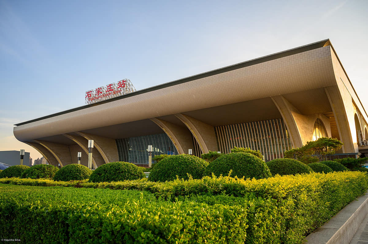
Shijiazhuang Railway Station
A contemporary passenger hub that makes rail central to the city's spatial story. Use live railway sources for timetables, security, transfers and accessibility.[5][1]
Hutuo River corridor
A metropolitan and agricultural water landscape involving channels, bridges, floodplain, habitat and recreation. Conditions vary by reach and date.[5]
Hebei Museum
The provincial collection is essential for reading archaeology and material culture beyond the modern city. Exterior images do not replace collection records or current exhibition information.[4]
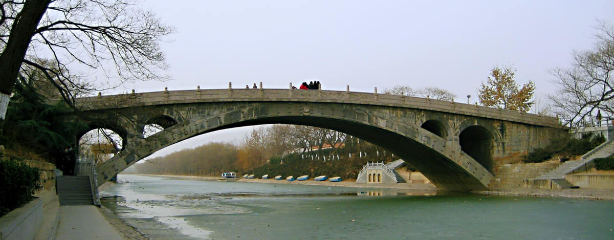
Zhaozhou Bridge
A major stone-bridge record in Zhao County. Historic structure, repairs, later visitor infrastructure and current river conditions must be distinguished.[5][6]
Zhengding wall and South Gate
A restored urban edge used for viewing and interpretation. Surviving fabric, reconstruction and modern safety installations are not the same evidence.[6][7]
Longxing Temple
A major living temple complex with architecture and sculpture from multiple periods. Worship, collections, conservation and tourism coexist.[6]
Kaiyuan Temple precinct
The Sumeru Pagoda, bell tower and surrounding space show monument concentration inside a living county seat. Each component has a separate chronology.[6]
Hua Pagoda
A visually distinctive pagoda at Guanghui Temple. Close architectural study and conservation records are needed beyond its recognizable silhouette.[6]
Lingxiao Pagoda
A tall Zhengding landmark associated with Tianning Temple. The exterior view cannot establish interior access or structural condition.[6]
Linji Temple
A living Buddhist site whose current religious use and institutional history extend beyond the architecture shown in one photograph.[6]
Zhengding Confucian Temple
A historic educational and ritual site encountered through gateway, courts and surviving buildings. The photographed gate is not the whole complex.[6]
Yanghe Tower
A reconstructed tower functioning as a contemporary urban and visitor landmark. It should never be captioned as wholly surviving ancient fabric.[6][7]
Zhengtai Hotel
A restored railway-heritage building that helps explain early modern urban growth. Current use and interior integrity require separate verification.[6]
Mount Cangyan and Fuqing Temple
A mountain religious and architectural landscape in Jingxing. Terrain, weather, crowds and trail access make live safety information essential.[7]
Zhongshan royal-tomb archaeological site
A Pingshan site interpreted through archaeology, museums and a current visitor landscape. Display buildings are not ancient tomb architecture.[6][4]
Xibaipo Memorial Hall
A contemporary memorial institution associated with dated twentieth-century events. Present buildings and historic site conditions must be kept distinct.[6]
Yutong sports venue and central public life
A large public venue representing contemporary sport and events. Calendars, naming, entry and capacity are live operational information.[1][7]
Ways to explore the city
Pair the modern center with at least one older county seat or western landscape to avoid a one-dimensional railway-city account.
Modern city and regional museum
Central city → Hebei Museum
Begin with Shijiazhuang's modern urban form, then use provincial collections to widen the historical frame.[1][2][3][4]
Zhengding architecture
City wall → Longxing Temple → historic pagodas
Read a long-lived county seat through walls, religious buildings, street scale, and conservation.[1][2][3][4]
Engineering and mountain geography
Zhaozhou Bridge → western Taihang route
Compare a plain river crossing with mountain settlements, roads, temples, and terrain.[1][2][3][4]