A lower-Yangtze metropolis where capital-city layers, hills and water, universities, museums, infrastructure, and neighborhood life remain visibly connected.
Capital-city history, the Yangtze, Ming city wall and tombs, museums, universities, Qinhuai River, and tree-lined urban landscapes[1][2][3][4]
Guide scope
Eleven districts across the historic core, Yangtze banks, Purple Mountain, new urban centers, lakes, towns, and southern rural landscapes[1][2][3][4]
Understand Nanjing as both capital archive and living river city
Nanjing sits on the lower Yangtze where river crossings, Purple Mountain, lakes and low hills have repeatedly shaped settlement, defence and expansion. The municipality covers 6,587.04 square kilometres and administers eleven districts; a complete account must include northern river districts, southern Gaochun and Lishui, industrial and university quarters, new towns and villages—not only the historic core.
The city has several historical names and many capital periods, but the useful story is not a slogan about an unbroken ancient capital. Jiankang's Six Dynasties landscape, the early Ming imperial city and walls, late-imperial upheaval, twentieth-century institutions, wartime atrocity, post-1949 industry and today's metropolitan infrastructure are distinct layers that need their own evidence.
Its humid subtropical monsoon climate brings four marked seasons, a damp plum-rain period and hot, humid summers, while winter can be cool and raw without northern-style continuous heating in every setting. Climate describes long-term patterns; live weather, heat, rain, flood, air-quality and seasonal-vegetation conditions must be checked separately.
The end-2025 permanent-resident population was 9.6385 million. That figure is a municipal statistical measure, not a portrait of one homogeneous population: routines differ across dense old neighbourhoods, university and research districts, Hexi, Jiangbei, transport hubs, industrial areas, county-level centres and rural communities.
Capital city
Multiple dynasties and later national institutions left different spatial and documentary layers.
Yangtze metropolis
Cross-river transport, ports, flood systems, wetlands, and new districts define the contemporary scale.
Museum and memory
Collections, archives, memorials, and heritage sites mediate difficult and complex histories.
Mountain-water city
Hills, lakes, canals, riverbanks, walls, and gardens make topography central to urban reading.
A visual record of the city
Twenty-seven locally hosted, rights-cleared images connect lake and skyline, city wall and archaeological traces, museums, living religious sites, difficult wartime memory, university and science institutions, transport, outer districts, craft, festival and food. Captions distinguish dated scenes, original fabric, repair, reconstruction, temporary works, visible symbols and live visitor information.
Image credits and licenses
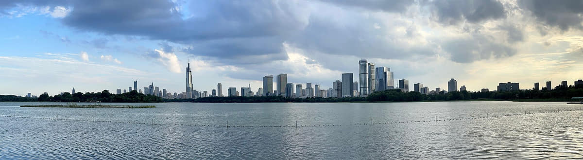
Nanjing across Xuanwu Lake, 2024Photo: A Chinese ID · source · CC BY-SA 4.0
Chicken-broth soup bunsPhoto: Caitriana Nicholson from 北京 ~ Beijing, 中国 ~ China · source · CC BY-SA 2.0
Museum display of the water eight delicaciesPhoto: 白色瑰宝 · source · CC BY-SA 4.0
Location, boundary, and 3D buildings
The central city lies south of the Yangtze around hills, lakes, walls, and the Qinhuai system; bridges and metro corridors connect districts on both banks and a much larger rural-urban municipality.[1][2][3][4]
Permanent residents across Nanjing's eleven districts; do not mix with registered-population or metro-area estimates
Population figures use the administrative area and source date shown below.[6][7]
Climate
Humid subtropical monsoon climate
Four distinct seasons include hot humid summers, a rainy early-summer period, cool winters, and variable spring and autumn transitions.
Climate describes long-term seasonal patterns; live conditions appear separately.[1][2][3][4]
Seasonal patterns
March–May
Spring
Temperatures rise quickly, flowering landscapes are prominent, and alternating rain and clear days favor flexible outdoor plans.[1][2][3][4]
June–August
Summer
Hot, humid conditions and the East Asian rainy season make shade, hydration, museums, and evening walks important.[1][2][3][4]
September–November
Autumn
Lower humidity and colored foliage make mountains, walls, campuses, and long urban walks especially readable.[1][2][3][4]
December–February
Winter
Cold, damp spells can feel sharper than the temperature suggests; indoor collections balance exposed river and wall routes.[1][2][3][4]
A short history of the city
Eleven evidence-led layers move from river-and-hill settlements through Eastern Wu and Six Dynasties Jiankang, the early Ming capital, late-imperial upheaval, Republican-era institutions, Japanese invasion and the Nanjing Massacre, post-1949 industry and today's eleven-district municipality.
Image credits and licenses
Ming Xiaoling's Spirit WayPhoto: Chainwit. · source · CC BY 4.0
Memorial Hall exteriorPhoto: Gary Todd from Xinzheng, China · source · CC0
Ming Palace Ruins Park, 2025Photo: Suicasmo · source · CC0
River-and-hill settlements before the capitals
Archaeological sites around lakes, river terraces and low hills show long settlement before the famous capitals. Evidence is uneven across the modern municipality, so individual sites should not be used to claim one continuous urban centre or a single ancestral community.[5][15]
Eastern Wu establishes a capital
In 229 Sun Quan made Jianye the capital of Eastern Wu. Court, military, water transport and settlement expanded, but later construction and river change mean the Three Kingdoms city cannot be read directly from today's street plan.[5]
Jiankang and the Six Dynasties
Eastern Jin and southern dynasties made Jiankang a major political and cultural centre amid large-scale migration, religious exchange and elite institutions. Tombs, texts and excavated material preserve fragments; 'Six Dynasties culture' should not erase workers, migrants or surrounding settlements.[5][15]
Regional city through changing dynasties
After the southern-capital era, administrative status, names, military importance and commercial networks changed repeatedly. Urban life continued in altered forms, but that does not justify a claim of unchanged capital institutions or an intact street-and-building sequence.[5]
Early Ming imperial city
The Ming dynasty established its first capital here in 1368, building palace, ancestral, administrative, city-wall and tomb landscapes on an exceptional scale. The capital later moved to Beijing; surviving wall and Ming Xiaoling belong to larger systems, while the palace survives mainly through archaeology and scattered remains.[9][11]
Late-imperial administration and upheaval
Nanjing remained a major lower-Yangtze administrative, educational and commercial centre. The Taiping Heavenly Kingdom made the city its capital as Tianjing from 1853 to 1864; war, siege, demolition and population loss transformed the urban landscape and require multi-source, non-romanticized treatment.[5]
Republican institutions and modern planning
Nanjing served briefly as the provisional capital in 1912 and became the seat of the Nationalist government in 1927. Administrative compounds, universities, roads, memorial landscapes and modern housing reshaped the city; describing these institutions is historical context, not a present political position.[5][15]
Japanese invasion and the Nanjing Massacre
After the Imperial Japanese Army captured Nanjing in December 1937, its forces committed mass killings, sexual violence, looting and other atrocities against civilians and prisoners of war. Documentation should name perpetrators and victims precisely, centre survivors and evidence, avoid sensational imagery, and never reduce the event to a vague 'wartime conflict.'[14]
Industry, education and public infrastructure
After 1949, manufacturing, research, universities, housing, transport and public services expanded. The Yangtze River Bridge became a visible engineering landmark, but the city's development also depended on workers, neighbourhoods, supply systems and institutions beyond monumental projects.[5]
Metropolitan expansion and conservation
Reform-era growth added development zones, metro lines, Hexi, new housing and stronger cross-river links while heritage sites were excavated, restored, reused or commercialized. Conservation quality varies, and historic-looking facades do not automatically prove original fabric.[5][9]
Eleven districts and 9.6385 million residents
Nanjing now administers eleven districts across both banks of the Yangtze and southward to Lishui and Gaochun. The end-2025 bulletin reports 9.6385 million permanent residents; year, municipal boundary and permanent-resident scope must accompany comparisons.[6][7]
People, language, and everyday rhythms
Eight perspectives describe 9.6385 million permanent residents through statistical scope, district difference, education, labour, migration, language, seasons and the resident–visitor balance—without assigning one identity to everyone.
Population measure
The headline figure is 9.6385 million permanent residents at the end of 2025. Registered population, census counts and metro-area estimates answer different questions and should not be mixed without labels.[6][7][5][8]
Eleven districts
Xuanwu, Qinhuai, Jianye, Gulou, Pukou, Qixia, Yuhuatai, Jiangning, Liuhe, Lishui and Gaochun contain markedly different densities, industries, landscapes and commuting patterns. A central-city photograph cannot represent all residents.[6][7][5][8]
Students and researchers
Universities, laboratories, libraries and hospitals draw students and specialists from many regions. Campuses shape neighbourhood rhythms, but a prestigious name or building does not prove individual experience, access, teaching quality or research performance.[6][7][5][8]
Manufacturing and services
Factory workers, engineers, logistics staff, rail crews, retailers, carers, hospitality workers and public-service teams sustain the metropolitan system. Landmark-centred narratives should not make this labour invisible.[6][7][5][8]
Migration and neighbourhood change
Nanjing's population has been repeatedly reshaped by historical migration, war, education, state institutions and contemporary employment. Ancestry, accent and length of residence vary; no resident should be treated as more authentic solely because of one marker.[6][7][5][8]
Language
Standard Mandarin is widely used, while local speech belongs to Lower Yangtze Mandarin and varies across districts and generations. Accent cannot reliably determine identity, education, class, temperament or political belief.[6][7][5][8]
Seasonal routines
Plum rain, summer heat, autumn outings and damp winter cold affect clothing, commuting, food, parks and indoor life. Exposure differs by age, housing, work, health and mobility, so a single seasonal stereotype is inadequate.[6][7][5][8]
Residents and visitors
Tourism concentrates around the Confucius Temple, Purple Mountain, museums and wall sections, while most daily life continues elsewhere. Responsible coverage balances visitor landmarks with year-round housing, transport, education, work and public-space needs.[6][7][5][8]
Jiming Temple and the modern skyline, 2024Photo: Chainwit. · source · CC BY 4.0
City of Literature
Nanjing joined UNESCO's Creative Cities Network as a City of Literature in 2019. The designation points toward publishing, libraries, education, writers and public programmes; it should not become a claim that every historical text or current event is automatically representative.[12]
Museums, archives and archaeology
Nanjing Museum, specialist museums, archaeological sites and archives make material evidence central to the city story. Exhibition labels, provenance, contested interpretation, closures and image rights still require object- and institution-level checks.[10][15]
Yunjin brocade
UNESCO records Nanjing Yunjin craftsmanship as an intangible cultural-heritage practice involving complex loom work and specialist knowledge. A finished textile cannot show the whole process, prove hand production, name its maker or establish that all brocade sold in the city follows the tradition.[13]
Qinhuai Lantern Festival
Lantern making, temporary installation, ritual calendar, commerce and crowd management meet around the Confucius Temple and other venues. Every edition has its own works, dates and routes, so photographs must retain year and edition.[16]
Craft ecologies
Block printing, paper cutting, gold-leaf work, lantern making and other practices survive through makers, workshops, institutions and markets. A museum display is evidence of interpretation, not proof that a craft is thriving or that a displayed object was locally made.[17][15]
Education and public learning
Universities, schools, observatories, libraries and lectures make learning visible in neighbourhood life. Institutional reputation should be separated from documented programmes, and public access should never be inferred from an attractive campus image.[12][5]
Living religious sites
Buddhist temples and other religious sites are not simply picturesque heritage. Worship, monastic life, ritual calendars, museum use and tourist access can overlap but should be described separately and respectfully.[5][15]
Wall as infrastructure and public space
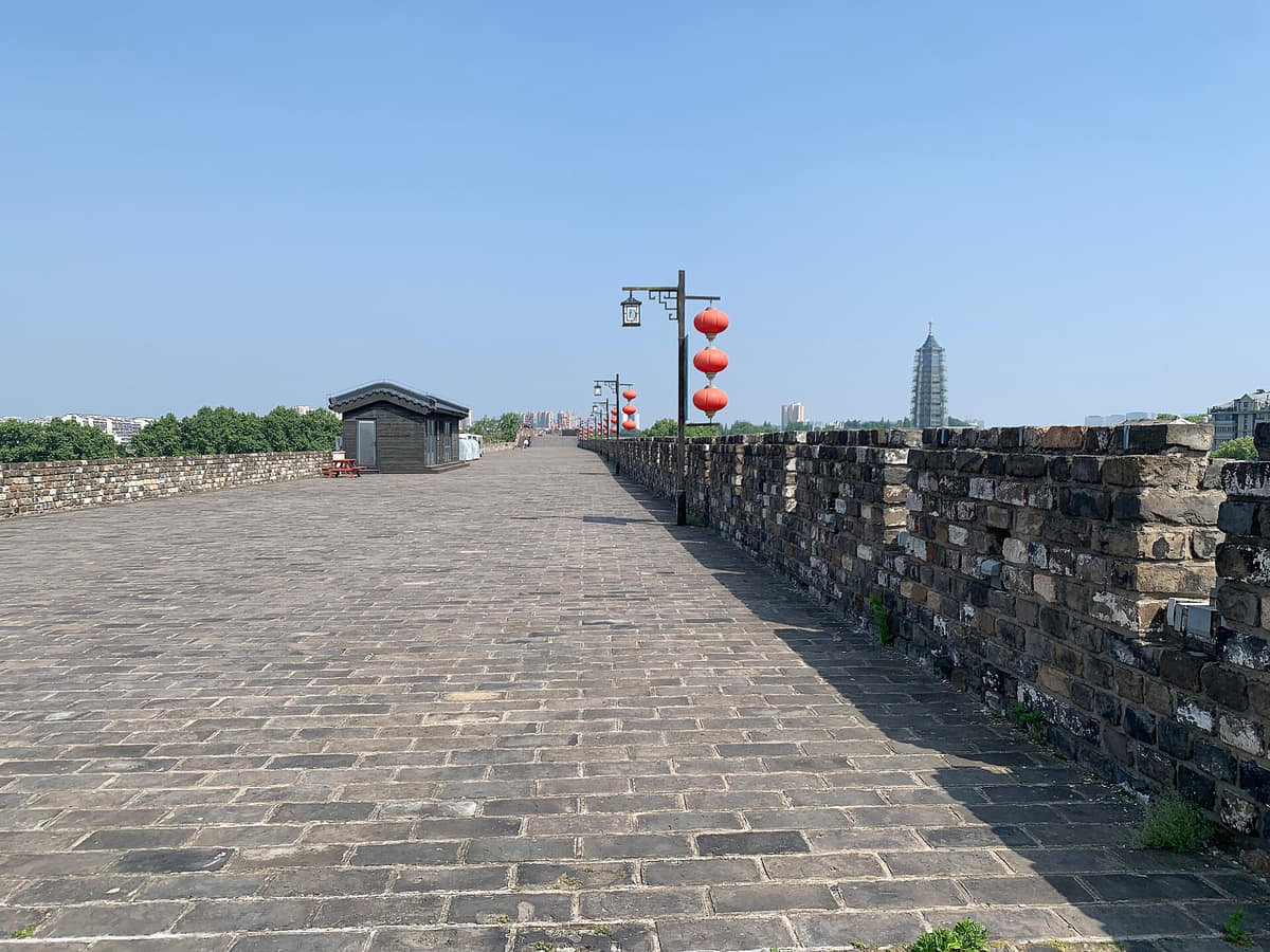
The Ming wall is simultaneously archaeological fabric, engineering, boundary, viewpoint, museum subject and managed public space. Conservation, reconstruction, vegetation, ticketing and urban reuse differ by section.[9]
Difficult memory
The Nanjing Massacre belongs to documented history and continuing survivor, family, educational and memorial practice. Responsible presentation names the Imperial Japanese Army's atrocities, centres victims and evidence, avoids spectacle, and does not use remembrance for unrelated political claims.[14]
Mountains, lakes and parks
Purple Mountain, Xuanwu Lake, Qixia Mountain and neighbourhood green spaces support exercise, seasonal observation, ecology and public gathering. Scenic imagery cannot establish biodiversity, trail safety, bloom or foliage timing, or unrestricted access.[8][5]
District diversity
Gaochun's streets and lakeside foodways, Lishui's towns, Jiangbei development, industrial Qixia and research-heavy central districts contribute different identities. 'Nanjing culture' is a network, not a single old-city performance.[7][17]
Contemporary design and mobility
Metro lines, South Station, Hexi towers, riverfront parks and pedestrian bridges add a contemporary visual language. Their cultural value includes planning, labour and everyday use, not only photogenic form; operations and access require live data.[5]
Food and local flavor
Fourteen entries place duck-blood soup, salted and roast duck, soup buns, beef potstickers, wontons, sweet snacks, seasonal aquatic and land produce, Qinhuai snacks, river foods and tea inside recipe variation, district context, allergens, dietary rules, provenance and current food safety.
Chicken-broth soup bunsPhoto: Caitriana Nicholson from 北京 ~ Beijing, 中国 ~ China · source · CC BY-SA 2.0
Museum display of the water eight delicaciesPhoto: 白色瑰宝 · source · CC BY-SA 4.0
Qinhuai and Confucius Temple areaPhoto: Dick Rochester · source · CC BY-SA 2.0
Duck-blood and vermicelli soup
Soup and vermicelli
Duck blood, sweet-potato vermicelli, broth and optional duck offal or garnish form many local versions. Chronicles document its history, but no single origin story or bowl defines the dish; poultry, organ meat, soy, gluten and food handling require venue checks.[19][18]
Nanjing salted duck
Cured duck
Salt, aromatic seasoning, resting and cooking produce a pale, firm duck associated with the city and seasonal eating. Producers differ in technique and supply; verify origin, date, storage, sodium, certification and food safety from the actual product.[17][18]
Roast duck and pressed duck
Other duck preparations
Roasting, curing, pressing and air-drying create different products that should not be collapsed into 'Nanjing duck.' Names, texture, serving temperature, salt, bones and storage vary, and brand claims need independent evidence.[17][18]
Chicken-broth soup buns
Broth-filled bun
Thin wheat wrappers hold meat filling and hot broth in a recognized snack form. Fillings and folding vary; ask about meat type, soy, sesame, alcohol in seasoning, cross-contact and safe temperature before eating.[20][18]
Beef potstickers
Pan-fried snack
Crisp-bottomed beef dumplings are linked with several Muslim-run food traditions and snack districts. Venue practice varies; halal compliance, beef source, wheat, sesame, cooking fat and shared equipment must be confirmed directly rather than inferred from a name.[20][18]
Skin-thin wontons in broth
Small wontons
Small wontons emphasize a light wrapper, broth and simple filling, often as breakfast or snack. Pork, shrimp, egg, wheat, soy, sesame and garnish vary, so the apparently clear broth is not evidence of dietary suitability.[20]
Osmanthus sugar taro seedlings
Sweet seasonal bowl
Small taro pieces in a sweet, thickened soup are commonly associated with autumn fragrance and local snack culture. Sweetness, starch, osmanthus product and serving temperature vary; the poetic name does not establish botanical source or seasonality.[17]
Sweet fermented-rice dumpling soup
Fermented rice sweet
Glutinous-rice balls and fermented rice produce a warm sweet soup with gentle acidity or alcohol aroma. Fermentation, sugar, gluten-free status, alcohol content and cross-contact vary and should be checked for children, pregnancy or dietary restrictions.[17]
Water eight delicacies
Aquatic vegetables
A seasonal foodways category groups aquatic plants and tubers from the lower-Yangtze lake-and-pond environment. Ingredient lists and availability vary by locality and year; a museum display is cultural evidence, not a freshness, harvest or sustainability certificate.[17]
Land eight delicacies and spring greens
Spring produce
Official cultural profiles also describe seasonal land produce and tender spring vegetables. Such groupings are flexible household and market knowledge, not a single canonical list; pesticides, washing, forage safety and provenance require current checks.[17]
Qinhuai snacks
Snack district
The Qinhuai label brings many small dishes into one visitor-facing tradition, but menus, recipes and venues change. Historical association should be separated from current quality, price, hygiene, authenticity marketing and accessibility.[20][18]
Fish, shrimp and wetland produce
River and lake food
Yangtze, lake and pond environments influence regional food, especially beyond the inner city. Species, wild or farmed source, closed seasons, bones, contamination risk, sustainability and price need current, product-level evidence.[17]
Yuhua tea
Local tea
Needle-like green tea is associated with Nanjing through production, naming and gifting, but grade, cultivar, harvest, processing and geographic origin vary. Packaging and award claims should be verified; caffeine remains relevant despite the cultural framing.[17]
Allergens, dietary rules and food safety
Eat with evidence
Duck, organ meat, pork, beef, wheat, soy, sesame, egg, shellfish, alcohol and shared equipment appear across local dining. Confirm ingredients, halal or vegetarian requirements, cross-contact, cooking temperature, storage and current inspections with the venue; imagery is never a safety guarantee.[18][20]
Landmarks and architecture
Image credits and licenses
Nanjing across Xuanwu Lake, 2024Photo: A Chinese ID · source · CC BY-SA 4.0
Gate within Sun Yat-sen MausoleumPhoto: Gary Todd from Xinzheng, China · source · CC0
The mausoleum of the Ming founder is part of UNESCO's serial World Heritage property. Approach roads, stone figures, vegetation, tomb architecture and later conservation form a landscape ensemble; a single gate or path does not represent the whole site.[11]
Nanjing City Wall
The early-Ming wall follows hills and water rather than a simple rectangle and survives in multiple sections. Original brick, missing portions, repair, reconstruction, ticketed walks and neighbourhood edges differ substantially by location.[9]
Zhonghua Gate
The former southern gate complex is known for deep defensive spaces and a massive barbican system. Exterior wall views communicate scale but not the interior sequence, construction chronology, restoration or current visitor route.[9]
Nanjing City Wall Museum
A contemporary museum beside the wall provides interpretation, collections and research context. Its new architecture is not Ming fabric, while current exhibitions, reservations, accessibility and opening require museum information.[9]
Xuanwu Lake
The lake links city wall, railway gateway, parks, islands and skyline in a central landscape. Water quality, boating, seasonal plants, event closures and crowd conditions cannot be inferred from a panorama.[5][8]
Sun Yat-sen Mausoleum
A twentieth-century memorial complex climbs a long Purple Mountain axis through gates, stairs and ceremonial buildings. Architectural and historical description does not imply political endorsement; current access and ceremonies need official checks.[21]
Jiming Temple
A living Buddhist institution near Xuanwu Lake and the wall, repeatedly rebuilt and embedded in a changing skyline. Religious use, historic fabric, reconstruction, tourist access and seasonal blossom viewing should be distinguished.[5][15]
Qixia Mountain
The eastern mountain landscape combines geology, woodland, Buddhist heritage and seasonal visitation. Autumn colour is temporary; trail safety, fire control, temple etiquette, transport and opening need current evidence.[5][8]
Nanjing Museum
A major museum institution with archaeology, art, history and specialist collections. Exterior architecture is only an entry point; collection provenance, gallery rotations, temporary exhibitions, booking and rights need item-level or museum-level information.[10]
Qinhuai River and Confucius Temple area
A dense visitor district of waterways, bridges, ritual architecture, examination-history sites, shops and performance. Historic fabric and reconstruction coexist; boats, lighting, events, prices and congestion change frequently.[5][16]
Presidential Palace complex
The present museum complex overlays late-imperial administrative sites and several twentieth-century institutions. Gate symbols are dated evidence; interpretation should distinguish periods and avoid turning historical description into a current political statement.[5][15]
Memorial Hall of the Victims in Nanjing Massacre by Japanese Invaders
A memorial, museum and evidence site addressing atrocities committed by the Imperial Japanese Army after the 1937 capture of Nanjing. Visit with respect; factual records, victims and survivors—not spectacle—must remain central.[14]
Nanjing Yangtze River Bridge
The combined rail-and-road bridge is a major twentieth-century engineering and mobility landmark. Scenic appreciation should be separated from live traffic, rail operations, maintenance, structural condition and safe viewing access.[5]
Nanjing South Railway Station
A large high-speed-rail gateway connecting local metro travel with regional and national routes. Architecture is documentable; departures, entrances, security, transfers, assistance and accessible routes are live operational data.[5]
Ming Palace Ruins Park
Public green space and scattered architectural remains mark the former early-Ming palace area. It should be read archaeologically: surviving stones, displaced material, later roads and landscape design do not reconstruct a complete palace.[5][15]
Purple Mountain Observatory
A science institution and heritage landscape on Purple Mountain that connects astronomy, instruments, buildings and public education. Current research, instrument condition, weather and public access require official confirmation.[5]
Gaochun historic street
A southern-district commercial street that broadens the municipal map beyond central Nanjing. Shopfronts, restored buildings, local food and everyday use coexist, but authenticity, tenants, prices and access must be checked building by building.[7][17]
Ways to explore the city
Use walls, water, museums, and at least one outer district to connect the famous capital core with the contemporary municipality.
Capital layers
City Wall → Nanjing Museum → Ming Xiaoling
Compare urban defense, provincial collections, and imperial landscape without compressing different periods into one story.[1][2][3][4]
Water and daily life
Xuanwu Lake → Qinhuai River → Yangtze waterfront
Follow three water scales to see recreation, old-city commerce, infrastructure, ecology, and metropolitan growth.[1][2][3][4]
Municipality beyond the core
Metro edge → Lishui or Gaochun landscape
Leave the historic center to read towns, fields, lakes, manufacturing, and rural heritage inside the same municipality.[1][2][3][4]
Planning collection
Plan a first visit to Nanjing
Four focused guides turn the complete city profile into seasonal, itinerary, and food decisions.