
Nanjing First-Time Guide: What to See and How to Plan
Plan a first visit to Nanjing with realistic timing, cultural context, priority landmarks, seasonal guidance, and routes that reflect the city's geography.
The short answer
Three days allow one wall-and-old-city day, one Purple Mountain and museum day, and one water or neighborhood day. The city’s historical layers are clearer when they are not collapsed into one dynasty.
What to prioritize
Nanjing sits on the lower Yangtze where river crossings, Purple Mountain, lakes and low hills have repeatedly shaped settlement, defence and expansion. The municipality covers 6,587.04 square kilometres and administers eleven districts; a complete account must include northern river districts, southern Gaochun and Lishui, industrial and university quarters, new towns and villages—not only the historic core. The city has several historical names and many capital periods, but the useful story is not a slogan about an unbroken ancient capital. Jiankang's Six Dynasties landscape, the early Ming imperial city and walls, late-imperial upheaval, twentieth-century institutions, wartime atrocity, post-1949 industry and today's metropolitan infrastructure are distinct layers that need their own evidence. Its humid subtropical monsoon climate brings four marked seasons, a damp plum-rain period and hot, humid summers, while winter can be cool and raw without northern-style continuous heating in every setting. Climate describes long-term patterns; live weather, heat, rain, flood, air-quality and seasonal-vegetation conditions must be checked separately. The end-2025 permanent-resident population was 9.6385 million. That figure is a municipal statistical measure, not a portrait of one homogeneous population: routines differ across dense old neighbourhoods, university and research districts, Hexi, Jiangbei, transport hubs, industrial areas, county-level centres and rural communities.
Ming Xiaoling
The mausoleum of the Ming founder is part of UNESCO's serial World Heritage property. Approach roads, stone figures, vegetation, tomb architecture and later conservation form a landscape ensemble; a single gate or path does not represent the whole site.[11]
Nanjing City Wall
The early-Ming wall follows hills and water rather than a simple rectangle and survives in multiple sections. Original brick, missing portions, repair, reconstruction, ticketed walks and neighbourhood edges differ substantially by location.[9]
Zhonghua Gate
The former southern gate complex is known for deep defensive spaces and a massive barbican system. Exterior wall views communicate scale but not the interior sequence, construction chronology, restoration or current visitor route.[9]
Nanjing City Wall Museum
A contemporary museum beside the wall provides interpretation, collections and research context. Its new architecture is not Ming fabric, while current exhibitions, reservations, accessibility and opening require museum information.[9]
Xuanwu Lake
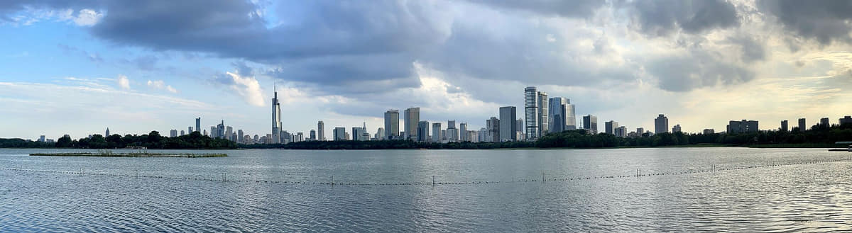
The lake links city wall, railway gateway, parks, islands and skyline in a central landscape. Water quality, boating, seasonal plants, event closures and crowd conditions cannot be inferred from a panorama.[5][8]
Sun Yat-sen Mausoleum
A twentieth-century memorial complex climbs a long Purple Mountain axis through gates, stairs and ceremonial buildings. Architectural and historical description does not imply political endorsement; current access and ceremonies need official checks.[21]
Build a realistic first visit
- Choose specific city-wall sections; surviving, restored, interrupted, and museum-interpreted portions offer different experiences.
- Purple Mountain sites involve long approaches and stairs, so combine fewer monuments with more landscape time.
- Use Nanjing Museum or the City Wall Museum to separate archaeological evidence, later memory, and present interpretation.
- Treat Qinhuai commercial areas, living neighborhoods, the Yangtze waterfront, and Xuanwu Lake as different water-city contexts.
Seasonal orientation
Spring
Temperatures rise quickly, flowering landscapes are prominent, and alternating rain and clear days favor flexible outdoor plans.[1][2][3][4]
Summer
Hot, humid conditions and the East Asian rainy season make shade, hydration, museums, and evening walks important.[1][2][3][4]
Autumn
Lower humidity and colored foliage make mountains, walls, campuses, and long urban walks especially readable.[1][2][3][4]
Winter
Cold, damp spells can feel sharper than the temperature suggests; indoor collections balance exposed river and wall routes.[1][2][3][4]