A high-altitude river-valley capital where living Tibetan Buddhist landscapes, homes, markets, museums, contemporary institutions, agriculture, county routes, and careful altitude adaptation coexist.
Lhasa River valley, Potala Palace, Jokhang and Barkhor, Norbulingka, Tibetan Buddhist learning and pilgrimage, high-altitude daily life, museums, and county landscapes[1][2][3][4]
Guide scope
Eight county-level units spanning the urban river terrace, old and new districts, agricultural valleys, Damxung grasslands, high passes, county towns, monasteries, farms, and remote mountain communities[1][2][3][4]
Understand Lhasa as an inhabited highland valley, not a collection of monuments
Lhasa's core occupies terraces beside the Lhasa River at high altitude, where mountains, thin air, strong sun, dry conditions, irrigated fields, and large temperature ranges structure daily life.
Potala, Jokhang, Barkhor, Norbulingka, monasteries, and museums are essential, but they remain connected to residents, worshippers, shops, schools, services, transport, conservation, and visitors. Five outer counties extend the story into grasslands, farming valleys, high passes, towns, and remote communities.
The city must be read at two scales: a high-altitude urban valley of homes, schools, markets, parks and institutions, and a much larger municipality of farming valleys, grasslands, high passes, monasteries, county towns and remote settlements.
Altitude is an operating condition, not a visual theme. Acclimatization, ultraviolet exposure, hydration, medical needs, road weather, temple rules, photography limits and opening information require current, site-specific checks.
High-altitude adaptation
Thin air, strong sun, cold nights, dry conditions, pacing, building, agriculture, and transport shape daily life.
Living religious landscape
Temples, pilgrimage, scholarship, markets, residents, conservation, and visitors coexist in active urban space.
River-valley municipality
The Lhasa River, terraces, fields, wetlands, mountains, and eight units connect the core with varied county landscapes.
Specific, changing culture
Language, faith, work, education, migration, media, art, and personal choice keep Tibetan urban life varied and contemporary.
A visual record of the city
Eighteen locally hosted, rights-cleared images cover the central city, outer municipal areas, institutions, transport, daily space and food context. Captions distinguish city evidence from regional references and live conditions.
The core lies on river terraces between mountains; the municipality extends through irrigated valleys, high passes, grasslands, county seats, monasteries, villages, farms, and remote upland areas.[1][2][3][4]
High elevation, a river valley, terraces, strong sun, thin air, surrounding mountains, and eight county-level units define Lhasa.
High-altitude river valley
The central city lies around 3,650 meters above sea level on terraces beside the Lhasa River, enclosed by mountain ranges.[1][2][3][4]
Sun, cold, and thin air
Strong ultraviolet exposure, low oxygen, large day–night temperature ranges, dry air, and rapid weather changes shape daily adaptation.[1][2][3][4]
River agriculture
Irrigated fields, villages, wetlands, tributaries, grazing areas, and urban water systems occupy suitable valley floors and terraces.[1][2][3][4]
Eight units
Three districts and five counties extend from the urban valley to Damxung grasslands, high passes, monasteries, farms, mining areas, towns, and remote mountain communities.[1][2][3][4]
Permanent residents across all eight county-level units of Lhasa Municipality; do not mix with the central built-up area, registered population, pilgrims, visitors or tourists
Population figures use the administrative area and source date shown below.[1][2][3][4][5][6]
Climate
Highland temperate semi-arid monsoon climate
High elevation brings thin air, strong ultraviolet exposure, large day–night temperature ranges, dry sunny winters, and a short summer rainy season concentrated mainly at night.
Climate describes long-term seasonal patterns; live conditions appear separately.[1][2][3][4][5][6]
Seasonal patterns
March–May
Spring
Wind, dust, intense sun, cold mornings, and gradual greening require layers, sun protection, hydration, and cautious acclimatization.[1][2][3][4]
June–September
Summer
Days are relatively mild, most rain falls at night or in storms, and mountain travel requires current weather and road information.[1][2][3][4]
October–November
Autumn
Clear skies, strong light, cold nights, and dry air favor valley views while requiring sun and cold protection.[1][2][3][4]
December–February
Winter
Sunny days can contrast with freezing nights, dry air, thin oxygen, and snow or ice on higher routes.[1][2][3][4]
A short history of the city
Valley settlement, religious and urban institutions, pilgrimage, markets, learning, twentieth-century infrastructure, and contemporary conservation form several timelines.
Archaeology, farming, herding, river terraces, and mountain routes document long habitation in and around the valley.[1][2][3][4][5][6]
Religious and urban center
Royal, religious, monastic, craft, trade, and pilgrimage institutions concentrated around the valley and old city.[1][2][3][4][5][6]
Monasteries, estates, markets, and learning
Religious institutions, agriculture, workshops, trade routes, scholarship, and seasonal gatherings shaped the regional center.[1][2][3][4][5][6]
Roads and urban change
Roads, public institutions, housing, utilities, schools, hospitals, migration, and conservation changed the valley city.[1][2][3][4][5][6]
Expanded highland municipality
Rail, aviation, roads, tourism, services, universities, new districts, restoration, and environmental management intensify connection and change.[1][2][3][4][5][6]
River terraces and exchange
Agriculture, pastoral routes, river crossings and highland exchange supported settlement before later monumental institutions took shape.[1][2][3][4][5][6]
Urban and religious center
Palatial, temple and monastic institutions developed over many periods; foundation dates, present buildings and later repairs must not be collapsed into one moment.[1][2][3][4][5][6]
Roads, institutions and new districts
Road transport, public services, schools, hospitals, housing and administrative expansion changed the scale and routines of the valley city.[1][2][3][4][5][6]
Conservation and urban growth
Old-city protection, museum work, public infrastructure, rail, tourism management and county connections operate alongside living religious practice and residence.[1][2][3][4][5][6]
People, language, and everyday rhythms
Residents include old-city and new-district households, Tibetan and other communities, monastic and lay populations, students, workers, traders, farmers, herders, county residents, and migrants.
Languages
Tibetan and Standard Mandarin are widely present, with other languages used by residents, migrants, traders, students, and visitors.[1][2][3][4][5][6]
High-altitude routines
Sun protection, hydration, pacing, heating, transport, seasonal work, and acclimatization affect residents and visitors differently.[1][2][3][4][5][6]
City and counties
Old-city households, new districts, public and service workers, monastic communities, farmers, herders, county residents, students, and migrants follow different routines.[1][2][3][4][5][6]
Avoiding stereotypes
Tibetan culture is living and internally varied; people should not be reduced to religion, costume, altitude, or timeless rural images.[1][2][3][4][5][6]
Old city, new districts and counties
Residents' routines differ across old-city lanes, university and service districts, river-edge neighbourhoods, farming valleys, county towns and pastoral areas.[1][2][3][4][5][6]
Respectful representation
Tibetan and other residents are contemporary individuals with varied beliefs, occupations, languages and choices; worshippers and residents are never visual attractions.[1][2][3][4][5][6]
Tibet UniversityPhoto: en:User:L8rpeace · source · CC BY 3.0
Tibetan Buddhist landscape
Temples, monasteries, pilgrimage, scholarship, ritual, art, printing, music, debate, and everyday devotion operate in specific institutions and communities.[1][2][3][4][5][6]
Architecture and conservation
Stone, timber, earth, paint, textiles, courtyards, hillside engineering, repair, fire safety, residents, and visitors shape heritage sites.[1][2][3][4][5][6]
Visual and material arts
Thangka painting, sculpture, metalwork, textiles, woodwork, manuscripts, printing, conservation, and contemporary art require maker and context attribution.[1][2][3][4][5][6]
Religious calendars, community festivals, family visits, performance, markets, and tourism overlap but should not be treated as one fixed spectacle.[1][2][3][4][5][6]
Contemporary highland city
Universities, museums, media, design, services, sports, transport, digital communication, and migration add changing urban forms of expression.[1][2][3][4][5][6]
Monastic learning
Sera, Drepung, Ganden and other institutions connect study, debate, ritual, art, printing, conservation and community life in distinct ways.[1][2][3][4][5][6]
Old-city living heritage
Barkhor lanes combine worship, circumambulation, homes, shops, teahouses, deliveries, utilities, fire safety, conservation and visitors.[1][2][3][4][5][6]
University and contemporary culture
Tibet University, museums, media, literature, visual arts, music, design and digital communication belong to the present-day city.[1][2][3][4][5][6]
County-specific practices
Festivals, craft, farming, herding, music and religious calendars vary by community and place; citywide labels should not erase that specificity.[1][2][3][4][5][6]
Food and local flavor
Barley, tea, dairy, noodles, filled dough, meat, potatoes, vegetables, rice, teahouse routines, household preferences, and regional or migrant cuisines shape the table.
Tea, butter, salt, churning, warmth, household practice, teahouses, and personal preference create varied use rather than one ceremonial image.[1][2][3][4][5][6]
Teahouse drink
Sweet milk tea
Tea, milk, sugar, thermos service, conversation, affordable teahouses, and changing urban routines make it widely visible.[1][2][3][4][5][6]
Roasted barley staple
Tsampa
Roasted barley flour is mixed in different ways with tea, dairy, sugar, or other ingredients across households and occasions.[1][2][3][4][5][6]
Everyday bowl
Tibetan noodles
Wheat noodles, broth, meat, scallion, radish, and shop-specific seasoning form a practical teahouse and restaurant meal.[1][2][3][4][5][6]
Shared food
Momos and filled dough
Steamed or fried dough with meat or vegetable fillings appears in homes and restaurants with changing sauces and formats.[1][2][3][4][5][6]
Municipal exchange
Valley and regional table
Barley, wheat, yak and other meats, dairy, potatoes, radish, greens, noodles, rice, migrant cuisines, and regional dishes coexist in the capital.[1][2][3][4][5][6]
Teahouse routine
Lhasa teahouse sweet tea
Milk, tea, sugar, thermos service and conversation create a common urban routine, but sweetness, price and venue practice vary.[1][2][3][4][5][6]
Everyday bowl
Tibetan noodle shops
Wheat noodles, broth, meat, radish, scallion and shop seasoning produce a practical meal rather than one fixed recipe.[1][2][3][4][5][6]
Roasted-barley staple
Tsampa preparation
Roasted barley flour may be mixed with tea, dairy, sugar or other ingredients; household methods and occasions differ.[1][2][3][4][5][6]
Home and restaurant food
Filled-dough traditions
Steamed or fried forms with meat or vegetable fillings circulate across homes and restaurants with varied sauces.[1][2][3][4][5][6]
Regional ingredient context
Yak and other meats
Species, cut, sourcing, storage, cooking and household preference matter; one photograph cannot establish safe handling or typical frequency.[1][2][3][4][5][6]
A changing capital table
Vegetables, rice and migrant cuisines
Potatoes, radish, greens, rice, noodles and cuisines brought by residents from other regions make the city table broader than a heritage menu.[1][2][3][4][5][6]
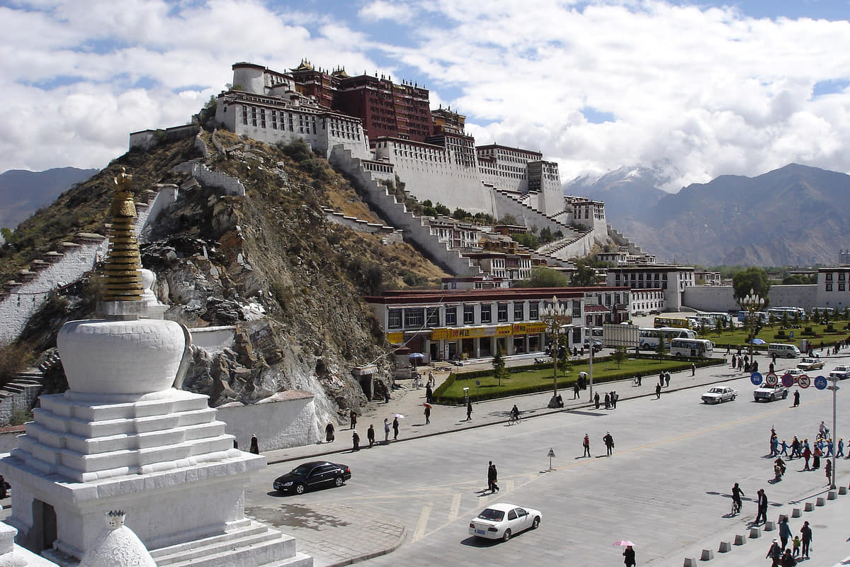
A hillside architectural ensemble combining religious and administrative histories, engineering, art, collections, pilgrimage, conservation, and city image.[1][2][3][4][5][6]
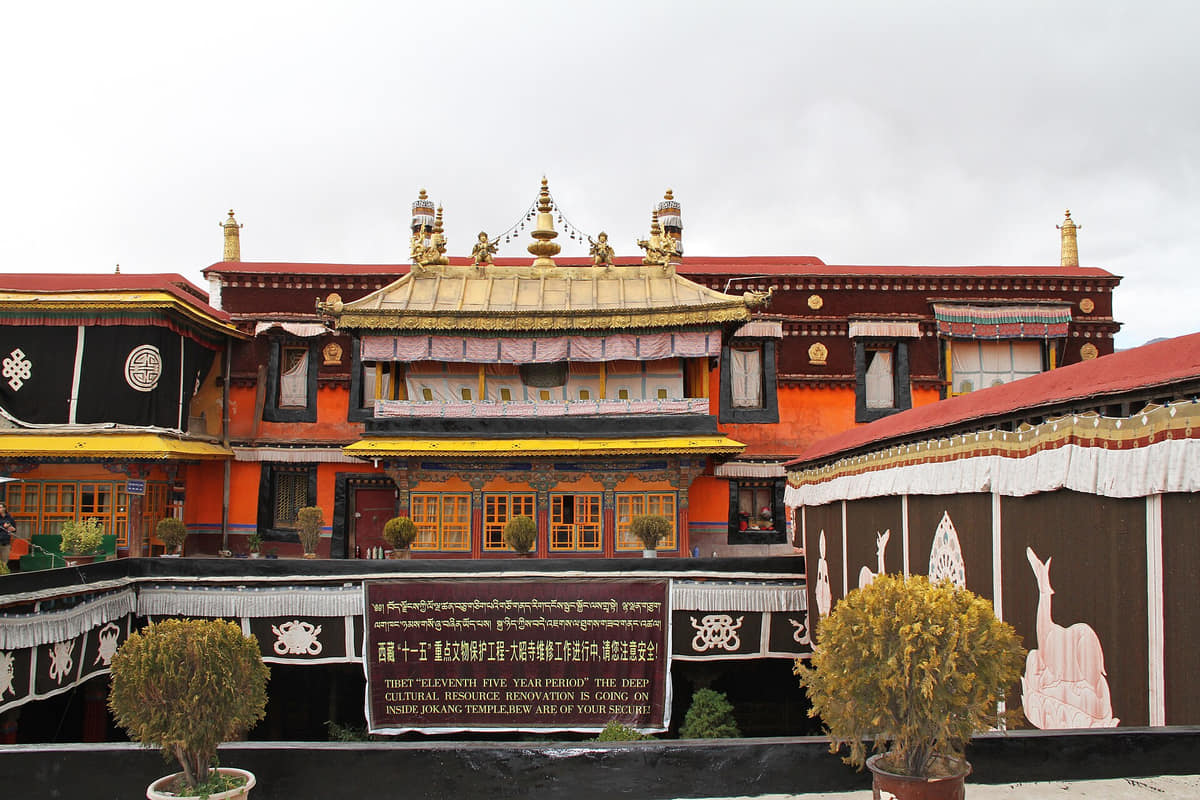
Jokhang Temple and Barkhor
A living old-city landscape where worship, circumambulation, trade, residence, tourism, conservation, and crowd management meet.[1][2][3][4][5][6]
Norbulingka
Palaces and gardens connect seasonal residence, art, water, vegetation, ritual, restoration, and public visitation.[1][2][3][4][5][6]
Tibet Museum
Collections and research provide essential context for archaeology, art, documents, material culture, conservation, and regional histories.[1][2][3][4][5][6]
Lhasa River
Terraces, wetlands, irrigation, bridges, settlements, roads, flood systems, agriculture, and mountain views explain the valley city.[1][2][3][4][5][6]
County landscapes
Damxung grasslands, high passes, monasteries, villages, farms, hot springs, mining areas, and county towns show the municipality beyond the core.[1][2][3][4][5][6]
Sera Monastery
An active religious and learning institution where architecture, study, ritual, conservation and visitor conduct require specific context.[1][2][3][4][5][6]
Drepung Monastery
A large hillside complex whose buildings, paths, worship, scholarship and conservation cannot be reduced to a panoramic view.[1][2][3][4][5][6]
Ganden Monastery
A municipal outer-area site that expands the guide beyond central Lhasa; road, altitude, weather and opening conditions matter.[1][2][3][4][5][6]
Ramoche Temple
A living religious site in the urban fabric; facade, institution, ritual and current access are separate questions.[1][2][3][4][5][6]
Lhasa Railway Station
A regional gateway that changed long-distance access while schedules, ticketing, security and high-altitude arrival needs remain live.[1][2][3][4][5][6]
Tibet University
A contemporary education and research institution that helps place Lhasa beyond monumental and pilgrimage narratives.[1][2][3][4][5][6]
Ways to explore the city
Acclimatize first, then connect old-city living heritage with museums, the river system, and one carefully planned county route.
Old-city living heritage
Jokhang → Barkhor → nearby lanes and teahouse
Observe worship, walking routes, trade, residence, conservation, visitor behavior, and everyday food without treating the area as a stage set.[1][2][3][4]
Institutions and gardens
Tibet Museum → Norbulingka → Lhasa River
Move from documented collections to garden heritage and the environmental system supporting the valley city.[1][2][3][4]
Municipal altitude
Central valley → Damxung or another county route
Compare the urban river terrace with grassland, farming valley, high pass, county town, and remote-community conditions using current road and weather advice.[1][2][3][4]
Planning collection
Plan a first visit to Lhasa
Four focused guides turn the complete city profile into seasonal, itinerary, and food decisions.