
Land and water
This city-specific topic connects place, daily life, and the wider municipal landscape: Land and water.
Sichuan Province · Sichuan Province, Southwest China
A three-river city where the Giant Buddha, Mount Emei, living religious landscapes, industrial and farming districts, Yi communities, handmade paper, and a dense food culture must be read at several scales.
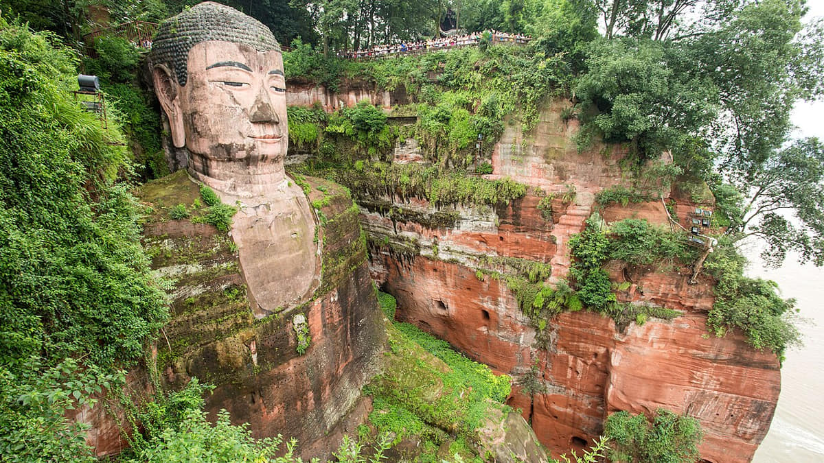
Leshan is an eleven-unit municipality, not a two-attraction itinerary. Shizhong contains the three-river urban core and Giant Buddha; Emeishan rises through subtropical forest to high-elevation pilgrimage sites; Wutongqiao and Shawan add salt, industry, old streets, literary memory, and the Dadu corridor; Jinkouhe, Ebian, and Mabian extend into steep mountain and Yi-community landscapes; Qianwei, Jingyan, Jiajiang, and Muchuan contribute rail, old towns, pagodas, irrigation, paper, tea, bamboo, farming, and county services.
The World Heritage property joins cultural and natural values. The Giant Buddha was begun in 713 and completed in 803 at the confluence of the Min, Dadu, and Qingyi rivers; Mount Emei combines long religious history with exceptional elevation, vegetation, and species diversity. Yet heritage is not static scenery: cliff drainage, stone weathering, biological growth, forest ecology, fire prevention, visitor pressure, active worship, transport, water and waste systems, monitoring, and repair decisions all require continuing work.
Craft and food reveal working systems behind the famous landscape. Jiajiang paper depends on bamboo or bark preparation, repeated pulping, sheet formation, pressing, drying, tools, water, labor, apprenticeship, and markets. Wutongqiao salt, Muchuan bamboo, Qianwei rail and town life, Ebian embroidery, Mabian tea and agriculture, street kitchens, wholesale supply, food safety, standards, and waste flows show how landscape, industry, household work, and consumption connect.
This guide uses neutral, evidence-led language. It separates documented chronology from legend; surviving fabric from repair or reconstruction; religious practice from tourism; ethnic self-representation from outsider stereotype; biodiversity records from scenic branding; and a named dish from one compulsory recipe. Image dates, access, opening hours, transport, flood, rockfall, forest-fire, food-allergy, hygiene, and conservation conditions can change and should be verified locally.
This city-specific topic connects place, daily life, and the wider municipal landscape: Land and water.
This city-specific topic connects place, daily life, and the wider municipal landscape: Historical layers.
This city-specific topic connects place, daily life, and the wider municipal landscape: Living culture.
This city-specific topic connects place, daily life, and the wider municipal landscape: County diversity.
Eighteen rights-cleared local images connect the three-river Giant Buddha landscape, Mount Emei summit and forest, conservation science, Wuyou Temple, food streets and three dishes, Jiajiang and Qianwei transport and craft, Shawan literary memory, Jingyan architecture, the Jinkouhe–Ebian gorge, and Mabian biodiversity.
This city-specific topic connects place, daily life, and the wider municipal landscape: Dadu–Min–Qingyi confluence.[1][2][3][4]
Four geographic relationships define Leshan.
This city-specific topic connects place, daily life, and the wider municipal landscape: Dadu–Min–Qingyi confluence.[1][2][3][4]
This city-specific topic connects place, daily life, and the wider municipal landscape: Mount Emei elevation gradient.[1][2][3][4]
This city-specific topic connects place, daily life, and the wider municipal landscape: Southern mountain counties.[1][2][3][4]
This city-specific topic connects place, daily life, and the wider municipal landscape: Eleven county-level units.[1][2][3][4]
Loading current conditions…
Forecast data: Open-MeteoPermanent residents across Leshan Municipality
Population figures use the administrative area and source date shown below.[1][2][3][4]Warm wet basin conditions shift rapidly with elevation around Mount Emei and southern mountain counties.
Climate describes long-term seasonal patterns; live conditions appear separately.[1][2][3][4]Temperatures rise quickly; rain, cloud, and local elevation call for flexible outdoor plans in Leshan.[1][2][3][4]
Warm wet basin conditions shift rapidly with elevation around Mount Emei and southern mountain counties.[1][2][3][4]
Clearer intervals and cooler evenings usually favor river, old-town, museum, and county routes.[1][2][3][4]
Damp cool conditions make layered clothing and indoor–outdoor route pairing practical.[1][2][3][4]
Nine evidence-led layers move from three-river settlement through the Tang Giant Buddha, Mount Emei, Jiajiang water and paper, Wutongqiao salt, Qianwei rail, Shawan memory, twentieth-century change, and contemporary World Heritage stewardship.
The Min, Dadu, and Qingyi systems linked fertile terraces, mountain approaches, ferry points, markets, and long-distance routes. Archaeology, tombs, inscriptions, place names, and later texts indicate deep settlement, but early communities cannot be projected unchanged onto today's municipal borders.[6][3]
The project joined Buddhist patronage with a hazardous confluence, red-sandstone carving, cliff access, drainage design, material removal, skilled and unskilled labor, food and supply systems, temples, and changing political support. Later stories illuminate memory but do not replace inscriptions, archaeology, architectural study, and conservation records.[5][8]
Religious institutions developed along routes that cross major elevation and vegetation zones. Monasteries, springs, bridges, inns, porters, farmers, forest use, scripture, ritual, repair, weather, landslides, wildlife, and later roads and cable systems formed a changing mountain network rather than one timeless sacred scene.[5][9]
Dongfengyan, Qianfoyan cliff carving, agricultural fields, settlements, water allocation, annual maintenance, flood risk, paper workshops, bamboo supply, and markets overlap in one landscape. Irrigation heritage remains functional; protection therefore involves hydraulic performance, archaeology, geology, water quality, farming, and community governance together.[13][10]
Well and brine systems, boiling, fuel, workers, merchants, tax and administrative institutions, river transport, architecture, wartime relocation, chemical expertise, pollution, industrial decline, and reuse shaped Wutongqiao. Nostalgic old-street imagery should not erase workplace hazards, environmental costs, or later residents.[18][15]
The Jiayang narrow-gauge railway served a coal-production system of mines, workers, stations, repair shops, fuel, water, freight, passenger needs, and surrounding farms. Tourism preserves visibility but changes operations, pricing, schedules, labor, emissions, safety, and local use. Qingxi and Luocheng add distinct street and market histories.[7][24]
Guo Moruo's former residence is one node in a wider landscape of family history, education, writing, research, museums, later commemoration, rail and river infrastructure, factories, hydropower, neighborhoods, and ecological change. A biography site should document chronology and sources without becoming present-day political advocacy.[7][15]
Modern transport connected the urban core, mines, salt and chemical works, farms, mountain counties, markets, schools, and hospitals, while topography kept access unequal. Industrialization, migration, reservoirs, conservation, hotels, mass tourism, and changing county administration created gains and costs that differed sharply by place and decade.[6][7]
World Heritage inscription strengthened international visibility but did not finish conservation. Stone monitoring, treatment trials, forest and wildlife management, fire and flood planning, crowd systems, religious-use coordination, public transport, accessible interpretation, food regulation, craft transmission, county livelihoods, and correction of outdated claims are ongoing responsibilities.[5][8][24]
Six perspectives center language and eleven local contexts; heritage labor; paper, bamboo, salt, rail, farm, and factory work; Yi communities; food work; and residents' needs beyond tourism.
Sichuan Mandarin is widespread, while Yi languages, accents, vocabulary, schooling, family origin, work migration, tourism contact, and generation vary. Shizhong, Wutongqiao, Shawan, Jinkouhe, Emeishan, Qianwei, Jingyan, Jiajiang, Muchuan, Ebian, and Mabian should never be collapsed into one personality type.[7][23]
Boat crews, masons, carvers, scaffolders, drainage workers, monastics, residents, researchers, photographers, surveyors, conservators, forest patrols, cleaners, firefighters, ticketing staff, guides, and transport workers occupy different roles. Heritage depends on routine care as much as famous historic patrons.[5][8]
Cutting and soaking fiber, pulping, lifting sheets, pressing and drying paper; managing bamboo; drilling and boiling brine; mining and maintaining rail; planting tea and crops; processing food; and operating factories involve skill, injury risk, gendered tasks, seasonality, market shifts, environmental duties, and changing technology.[10][18][19]
Community life includes language, schools, farming, tea, forest relations, clothing and embroidery, silverwork, music, food, ceremonies, markets, migration, digital media, public services, and individual choices. Present practices differ by village, household, gender, generation, and context; they are not costumes frozen for tourism.[20][23]
Slaughter and purchasing, early prep, stock, skewering, frying, braising, cooling, cleaning, refrigeration, serving, payment, delivery, queue management, inspection, waste, night work, allergies, and customer expectations produce Leshan's food economy. A famous dish should credit the full supply and labor chain.[14][16]
Children, older residents, commuters, farmers, factory and service workers, students, patients, caregivers, shopkeepers, religious communities, migrants, disabled people, and rural households use roads, schools, clinics, markets, parks, rivers, forests, temples, and digital services every day. Visitor convenience is only one municipal need among many.[7][2]
Twelve entries place qiaojiao beef, sweet-skin duck, bobo chicken, tofu pudding, skewers, Xiba tofu, eel and fish, Emei produce, Jiajiang fermentation, Qianwei market foods, Yi mountain foods, and everyday meals within technique, labor, safety, sourcing, and variation.
Beef and offal cuts, lawful sourcing, cleaning, blanching, stock, simmering, doneness, separation, holding temperature, herbs, salt, chile dip, bowl or pot service, bones, allergens, refrigeration, and shop variation matter. The name does not certify one origin story or recipe.[14][16]
Duck source, cleaning, brining or simmering, spices, sugar stage, surface drying or frying, doneness, cooling, chopping, bones, glaze, sweetness, refrigeration, cross-contamination, stall hygiene, and batch turnover shape quality and safety.[14][17]
Chicken, offal, vegetables, tofu, separate cooking times, cooling, skewers, stock or oil, chile, sesame, pepper, salt, shared containers, refrigeration, holding time, allergens, utensils, bone control, and fast turnover create substantial shop-to-shop difference.[14][16]
Soybeans, water, coagulant, curd texture, starch-thickened broth, meat, crisp crumbs, peanuts, pickles, herbs, chile, temperature, bowl assembly, freshness, allergens, sanitation, breakfast demand, takeaway, and neighborhood preference distinguish versions.[14][16]
Ingredient sourcing, raw and cooked separation, skewers, broth or oil, frying temperature, batch life, vegetables, meat, tofu, seafood, starches, chile, sesame, peanuts, sanitation, tongs, refrigeration, waste, price by weight, and queue pressure require disciplined operations.[14][16]
Soybean variety, soaking, grinding, filtering, boiling, coagulant, water, pressing, cutting, frying, steaming, braising, stuffing, sauces, freshness, allergens, kitchen organization, banquet sequencing, and restaurant innovation create a family of dishes rather than one plate.[14][17]
Species identification, protected-species and fishing rules, aquaculture or purchase records, water quality, cold chain, live holding, cleaning, bones, cutting, oil temperature, aromatics, chile, kitchen separation, cooking, and waste control come before any claim of wild origin.[14][17]
Tea cultivar, harvest, withering or fixing, storage, water and brewing; eel sourcing and handling; bamboo shoots, mushrooms, vegetables, herbs, and preserved foods each follow different seasons, safety rules, labor systems, and price cycles.[14][7]
Soybeans, tofu structure, starter, salt, vessels, temperature, time, microbial control, flavor additions, packaging, labeling, storage, and food regulation shape fermented tofu. Tea adds cultivar, field management, harvest, processing, grading, and market traceability.[14][13]
Mutton source, cuts, blanching, stock, doneness, herbs, offal, refrigeration, and service temperature matter alongside flour, fat, sugar, sesame, kneading, lamination, baking or frying, cooling, allergens, packaging, shelf life, and local shop histories.[14][7]
Buckwheat variety, milling, water, shaping and cooking; potato cultivar and frying oil; bamboo-shoot identification and processing; meat source, salting, smoking, drying, nitrite control, storage, reheating, ritual context, and household preference require separate description.[17][21]
Breakfast stalls, wholesale and produce markets, rural shops, school and factory canteens, temple-area meals, family kitchens, rice, noodles, vegetables, eggs, tofu, meat, fruit, payment, delivery, nutrition, allergies, inspection, accessibility, affordability, waste, and water describe daily eating more fully.[14][16]
Three routes pair the core city with contrasting county-level landscapes.
The site joins belief, river safety, cliff geology, labor, transport, engineering, pilgrimage, and modern conservation.
Read the story