A Songhua River metropolis where railway migration, severe winter, music, layered architecture, industrial history, and large rural landscapes shape one city.
Songhua River, ice and snow engineering, music, railway architecture, Central Street, and a diverse migration history[1][2][3][4]
Guide scope
The river city, 18 county-level units, wetlands, agricultural plain, eastern forests, and winter-sports landscapes[1][2][3][4]
Understand Harbin in more than one season
Harbin sits on both banks of the Songhua River in southern Heilongjiang. Its municipality spans a dense urban core and extensive districts, counties and county-level cities, so a complete reading must move beyond Central Street and winter festivals to river corridors, agricultural settlements and county towns.
Its climate is a temperate continental monsoon type with a long, very cold winter, a short warm-to-hot summer and brief transitions. That baseline shapes heating, clothing, food storage, river use and seasonal construction, but it must not be confused with live weather, ice safety or a forecast.
Modern Harbin grew rapidly around the Chinese Eastern Railway from the late nineteenth century, within an older river landscape with earlier settlements and regional histories. Railway investment, migration and trade brought Chinese and international communities together, leaving religious, commercial, industrial and residential layers that survive unevenly through original fabric, alteration, restoration and reuse.
The city is simultaneously a music centre, ice-and-snow production base, transport hub, manufacturing and research city, and a place of difficult wartime memory. This edition treats architecture, food and festivals as evidence-bearing practices rather than slogans, and separates historical fact, present use, commercial claim and live visitor information.
Railway and migration
Transport drew communities, institutions, architecture, and commerce into a rapidly growing city.
Winter systems
Cold affects engineering, food, clothing, public space, transport, and cultural production.
Music and exchange
Performance institutions and diverse historical communities shaped a visible musical identity.
River metropolis
The Songhua River explains the city in both warm and frozen seasons.
A visual record of the city
Twenty-seven locally hosted, rights-cleared images connect winter and summer river conditions, orbital and street-level urban form, historic and contemporary architecture, music venues, living religious sites, difficult wartime evidence, ice-and-snow production, campus life and food. Captions distinguish dated scenes, original fabric, restoration, adaptive reuse, commercial claims, temporary artworks and live visitor information.
Museum of Evidence of War Crimes by Japanese Army Unit 731Photo: EditQ · source · CC BY-SA 4.0
A festival snow sculpture in 2026Photo: Garosio33 · source · CC0
Large sculpture on Sun IslandPhoto: This image was made by Sadko . Please credit this with: "Sadko, Wikipedia" in the immediate vicinity of the image. A message to me would be appreciated as well. If you wish to use, license, or buy the image, please contact me to discuss terms. More of my work can be found in my personal gallery . · source · CC BY-SA 4.0
Boats on the river in 1904Photo: Unknown author Unknown author · source · Public domain
The central city straddles the Songhua River, while the municipality extends across broad agricultural plains, wetlands, forests, hills, counties, and winter-sports areas.[1][2][3][4]
Registered household population across Harbin's eighteen county-level units; not directly comparable with permanent-resident census totals
Population figures use the administrative area and source date shown below.[6][7]
Climate
Humid continental monsoon climate with very cold winters
Winters are long, dry, and extremely cold; summers are warm and humid, with most rainfall concentrated in the warm season.
Climate describes long-term seasonal patterns; live conditions appear separately.[1][2][3][4]
Seasonal patterns
March–May
Spring
Thaw, wind, rapid warming, and muddy transitions change river and street conditions quickly.[1][2][3][4]
June–August
Summer
Warm, humid days, long light, greenery, and concentrated rain create a very different city from the winter image.[1][2][3][4]
September–November
Autumn
Cool, clear weather and colored foliage arrive early; the first freezes can come well before winter tourism begins.[1][2][3][4]
December–February
Winter
Very cold temperatures, snow, frozen rivers, heating, short daylight, and ice engineering shape everyday systems and festivals.[1][2][3][4]
A short history of the city
Eleven evidence-led layers move from the pre-rail river landscape through railway-led growth, migration and hybrid architecture, Japanese occupation and Unit 731 war crimes, postwar industrialization, flood memory, reuse, research and today's eighteen-unit municipality.
Image credits and licenses
Boats on the river in 1904Photo: Unknown author Unknown author · source · Public domain
Communities lived and travelled through the Songhua basin long before the modern railway city. Wider regional histories include Jurchen and Jin-era sites, but these should not be collapsed into an unbroken story of today's urban centre.[5]
Railway-led acceleration
Construction and operation of the Russian-financed Chinese Eastern Railway within Qing China accelerated settlement, industry and transport. Rail was a decisive modern layer, not the beginning of all human history in the area.[5][13]
Migration, trade and multiple communities
People arrived from across China and abroad, establishing businesses, schools, hospitals, religious institutions and neighbourhoods. Surviving buildings reveal only part of those communities, many of which changed or dispersed through war and political upheaval.[5][13]
Architecture and municipal systems
Rail yards, embankments, commercial streets and buildings in varied styles formed a new cityscape. Present-day labels such as 'European' or 'Chinese Baroque' are useful only when original use, hybrid construction, later alteration and restoration are also explained.[13]
Japanese occupation and war crimes
Under Japanese occupation and the puppet state of Manchukuo, coercive rule reshaped institutions and industry. At Pingfang, Japanese Army Unit 731 conducted biological warfare research, human experimentation and other war crimes; museum interpretation must be evidence-led and victim-centred.[14][15]
Postwar transition
War's end brought institutional transfer, population movement and reconstruction. Railway, industrial, religious and residential sites took on new functions, so current use should not be mistaken for original ownership or uninterrupted continuity.[5][13]
Industrial and provincial-capital growth
As Heilongjiang's capital, Harbin expanded machinery, power, food processing, transport, education and public services. Industrial identity was built through workers, engineers and supply networks across both city and region, not by landmark factories alone.[5]
Flood memory and river engineering
The 1957 flood response became a major civic memory represented by the Flood Control Memorial Tower. A monument does not replace hydrological records, and current flood risk depends on live conditions and later engineering.[5]
Reform, expansion and reuse
New districts, housing and services grew while older commercial and religious buildings were restored, repurposed or commercialized. Conservation quality varies, so facade appearance alone cannot establish authenticity or continuity.[5]
Music, research and seasonal production
Concert venues, universities, ice engineering, snow sculpture and event operations add contemporary layers. Their value lies in institutions, labour and repeated practice as well as in spectacular buildings and festival images.[11][9]
Eighteen county-level units and changing population
Harbin administers nine districts, seven counties and two county-level cities. The 2024 bulletin reports 9.330 million registered household residents; that scope differs from the 2020 census permanent-resident measure and should not be compared without qualification.[5][6][7]
People, language, and everyday rhythms
Eight perspectives describe 9.330 million registered household residents through statistical scope, core–county difference, labour, universities, migration, language, seasons and tourism—without assigning one personality to everyone.
Population measures
The current headline uses 9.330 million registered household residents at the end of 2024. Census permanent residents answer a different question, so both year and scope must accompany any population figure.[6][7][5][8]
Core, suburbs and counties
Daily life differs between dense central districts, newer residential areas, industrial Pingfang, riverside Songbei, county seats and agricultural settlements. No single downtown scene represents the whole municipality.[6][7][5][8]
Railway and industrial labour
Drivers, maintainers, factory workers, engineers, logistics staff and food processors sustain identities often reduced to stations or brands. Conditions and employment change and require current sector-specific sources.[6][7][5][8]
Universities and research
Students, teachers and researchers form a visible part of Nangang and other districts. A campus image can show spatial life but cannot prove teaching quality, research performance, rankings or open access.[6][7][5][8]
Migration and community memory
Harbin's population history includes movement from other Chinese regions and overseas communities linked to rail, trade and refuge. Buildings and museums preserve fragments; they should not be used to stereotype present residents or imply unchanged communities.[6][7][5][8]
Language
Northeastern Mandarin is widely heard, alongside standard Mandarin and the languages or speech varieties of different families and communities. Accent is not a reliable guide to identity, origin, education or character.[6][7][5][8]
Seasonal routines
Heating, snow clearance, layered clothing and shorter outdoor stays shape winter; parks, riverbanks and late daylight reshape warm-season routines. These patterns vary by age, job, housing and mobility.[6][7][5][8]
Visitors and residents
Winter tourism creates seasonal work and pressure in transport, hospitality, public space and sanitation. A complete city account includes residents' year-round needs rather than treating Harbin only as a festival stage.[6][7][5][8]
Harbin's music identity rests on institutions, education, performance history and recurring public practice, not one title alone. UNESCO's Creative City record offers a framework; current programmes still need venue-level checks.[11][12]
Ice as skilled production
Ice architecture and snow sculpture require designers, surveyors, cutters, carvers, electricians, machine operators, safety teams and cold-chain timing. Finished photographs should not erase this labour or the temporary nature of the work.[9][10]
The seasonal river
The Songhua is transport corridor, ecological system, waterfront and winter surface at different times. Ice recreation never implies unrestricted safety, while summer imagery cannot establish water quality or navigation conditions.[5][8]
Hybrid architecture
Religious buildings, commercial blocks, railway infrastructure and local construction techniques produced varied forms. Labels should distinguish style from ownership, community history, original fabric, restoration and commercial reproduction.[13]
Jewish heritage
Former synagogues and other sites preserve part of Harbin's Jewish-community history, including migration and refuge. Present adaptive reuse can support memory but should not substitute for community records or imply continuity where history was disrupted.[13]
Chinese Baroque streets
Daowai's commercial buildings are read through hybrid facades and courtyard life. Renovation and tourism have altered many surfaces and businesses, so one decorated frontage is a sample, not proof of district-wide authenticity.[13]
Religious and ritual sites
Orthodox, Jewish, Buddhist and Confucian sites reflect distinct histories and uses. They should not be blended into a generic 'exotic' image, and current worship, museum use and visitor etiquette must be checked separately.[13]
Museums and difficult memory
Museums connect natural history, regional collections, music and wartime evidence. At the Unit 731 site, factual specificity and victim-centred language are essential; architectural tourism must never displace the documented crimes.[14][15]
Universities and public learning
Universities contribute research, migration, lectures, exhibitions and neighbourhood rhythms. Institutional reputation should be separated from verifiable programmes, and campus access should never be assumed from an image.[5]
Sun Island and public art
Park landscapes, sculpture and seasonal exhibitions create a different cultural register from downtown streets. Individual artworks still need title, creator, date and rights records before strong claims or close reproduction.[9]
Northeastern everyday culture
Conversation, shared dishes, markets, bathing, parks and practical responses to cold are lived practices rather than a fixed personality. Humour or direct speech should not be assigned to every resident as a regional stereotype.[5][17]
Festival city and year-round city
Winter spectacles are globally visible, but music, schools, factories, neighbourhoods, county towns and summer river life continue beyond the festival calendar. Editorial coverage should keep both scales in view.[11][9][5]
Food and local flavor
Fourteen entries place red sausage, dalieba, ice cream, guobaorou, fish and pot stews, suan cai, chunbing, grills and everyday staples inside migration, regional circulation, recipe variation, allergens, traceability and current food-safety context.
Image credits and licenses
Sliced Harbin red sausagePhoto: PangDifei · source · CC0
A recognizable city food shaped by smoking, seasoning, meat processing and local adaptation. Recipes and production scales vary; verify meat, casing, additives, allergens, storage, certification and producer rather than relying on the name.[16]
Dalieba
Large bread
Large round or oblong loaves reflect bakery traditions associated with Harbin's migration history. Retail examples differ in flour, fermentation, sweetness, nuts and shelf life, so wheat and nut allergens require product-level checks.[17]
Ice cream in winter and summer
Cold snack
Ice-cream bars on Central Street are a visible commercial ritual, including in cold weather. Brand stories do not replace ingredient, dairy, allergen, hygiene, price or current-operator information.[17][19]
Guobaorou
Sweet-sour frying
Fried pork slices in a sweet-sour glaze are strongly associated with Harbin and wider northeastern dining. Accounts of origin and standard recipe vary; thickness, starch, sauce, garnish and crispness differ by kitchen.[18]
Pastries and western-style dining
Bakery and café history
Cafés, breads and pastries reflect international exchange and local adaptation rather than a frozen copy of one foreign cuisine. Historic branding, current ownership, recipes and price should be verified independently.[17]
Fish stews and Demoli associations
River and county food
Fish stews are linked to river and roadside foodways, with Demoli in Fangzheng County prominent in regional storytelling. Species, aquaculture or wild origin, season, bones, price and sustainability need current evidence.[17]
Iron-pot stews
Cold-weather sharing
Large pots of meat, fish, beans, potatoes or corn support shared meals and heat retention. Ingredients and cooking time vary; diners should ask about bones, alcohol, allergens, cross-contact and complete cooking.[17][19]
Suan cai and pork dishes
Fermented vegetable
Fermented Chinese cabbage brings acidity to soups and stews, often with pork. Salt, fermentation method, pork cuts and serving style vary; sodium, meat content and food handling should be checked.[17]
Chunbing
Wrapped meal
Thin pancakes are assembled with shredded vegetables, egg, meat and sauces at the table. The practice is shared beyond Harbin and is not a fixed city recipe; wheat, soy, egg and sesame are common allergen questions.[17]
Skewers and barbecue
Grill culture
Meat, vegetables and breads move through grills, skewers and shared late-evening meals. Venue ventilation, charcoal or gas, doneness, marinades, cross-contact and alcohol service require live judgement.[19]
Mushrooms, grains and soy
Regional ingredients
Heilongjiang's agricultural and forest supply networks bring grains, soy products and mushrooms into Harbin kitchens. Regional availability does not prove local harvest, organic status or traceability for a specific dish.[17]
Frozen pears and candied hawthorn
Frozen winter fruit
Cold-weather snacks use ambient freezing, syrup or both, and belong to wider northeastern food culture. Teeth sensitivity, sugar, hygiene and thawing conditions matter; they are not exclusive Harbin inventions.[19]
Dumplings, noodles and rice
Home and canteen staples
Everyday meals are more diverse than signature-food lists. Fillings, flour, broth and condiments vary by household and venue, and vegetarian labels should be checked for stock, lard and shared equipment.[17]
Read the specific product and kitchen
Eating safely
City reputation cannot certify a meal. Ask about ingredients, allergens, dietary requirements, storage, fish bones, meat doneness and cross-contact; verify current food-safety notices and do not infer quality from queues or old-brand signs.[17][16]
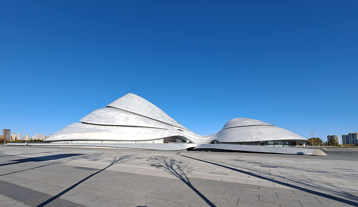
A contemporary riverside performance building whose flowing massing contrasts with the city's historic streets. Read it through architecture and performance infrastructure; current events, access and operations remain live.[11][13]
Central Street
A long pedestrian commercial spine with stone paving and mixed historic, restored and reconstructed facades. Distinguish building history from tenant marketing and verify crowd, weather and accessibility conditions.[13]
Saint Sophia Cathedral
A former Orthodox church now encountered as museum architecture and public square. Religious history, structural fabric, restoration and present exhibition use are related but not interchangeable.[13]
Harbin Ice and Snow World
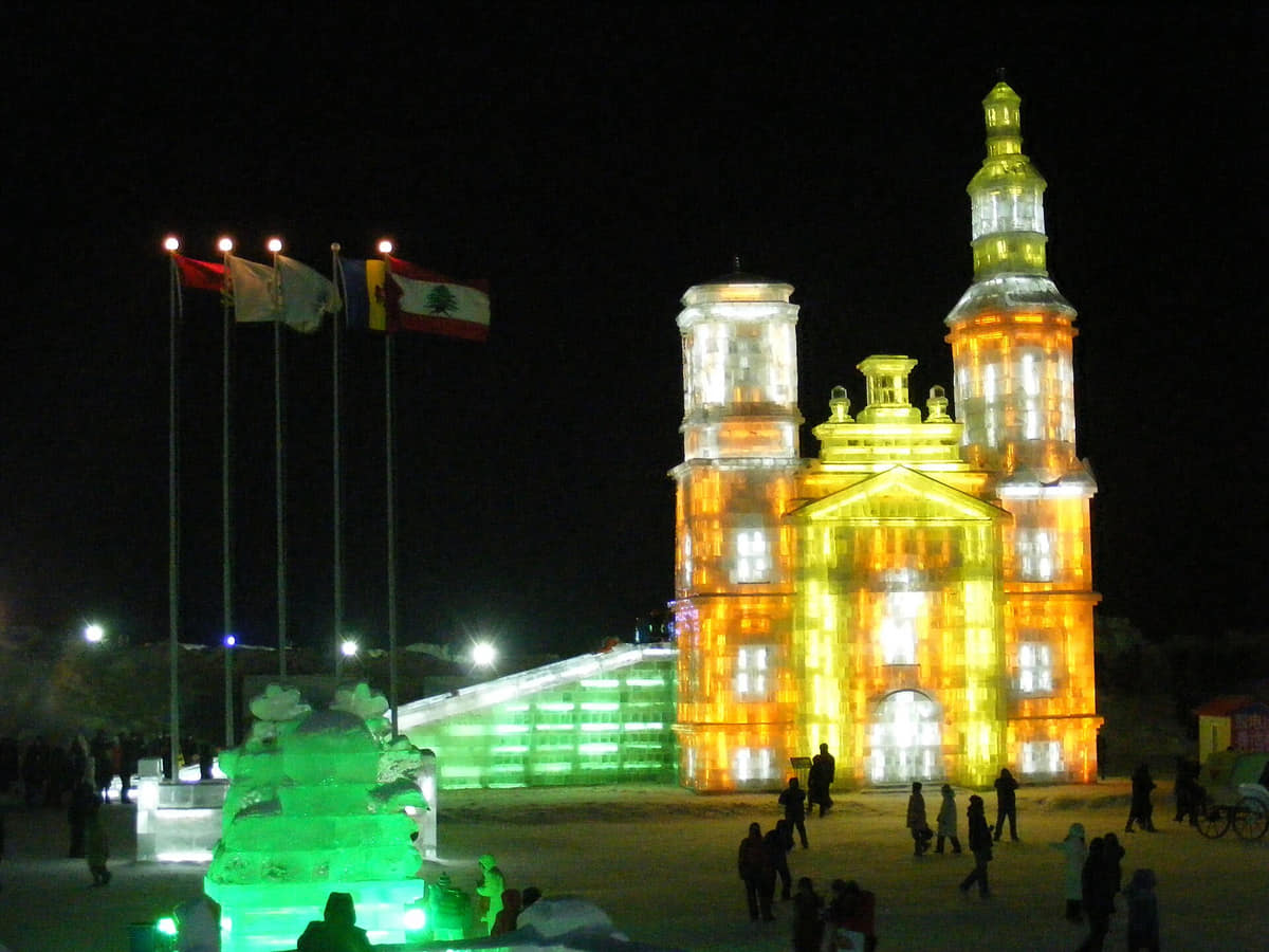
An edition-based winter landscape built from ice, snow, steel, light and temporary operations. Do not reuse a previous edition's map, theme, dates, ticket or safety information as current fact.[9][10]
Sun Island
A large riverside landscape associated with parks, public art and snow-sculpture activity. Seasonal access, individual artwork records, ecology and event boundaries need separate evidence.[9][5]
Flood Control Memorial Tower
A civic monument at the Songhua waterfront that anchors memory of the 1957 flood response. Use it as an entry to documented history, not as a present flood-safety indicator.[5]
Former Binzhou railway bridge
A steel crossing that exposes the physical relationship between railway growth and the Songhua River. Heritage use, engineering condition, pedestrian access and adjacent active transport must be checked live.[5][13]
Harbin Railway Station
A current transport gateway carrying the railway story into everyday mobility. Architecture is stable enough to document; entrances, platforms, services, security and accessible routes are not.[5]
Harbin Concert Hall
A purpose-built performance venue in Qunli that helps distribute music culture beyond heritage buildings. Verify programme, ticketing, age rules, accessibility and transport for each visit.[11]
Old Synagogue Concert Hall
An adapted former synagogue whose current music use overlays a distinct Jewish-community and religious history. Interpretation should identify both layers without treating reuse as unchanged continuity.[11][13]
Chinese Baroque historic area
A Daowai district of hybrid commercial and courtyard architecture, now affected by conservation, reconstruction and tourism. Evaluate buildings individually rather than generalizing from one decorated street.[13]
Harbin Confucian Temple
A formal ritual complex whose approach, gates and courtyards require attention to axial order, restoration and museum interpretation. Visitor rules and ceremonial use may change.[13]
Jile Temple
A living Buddhist complex embedded in a busy urban landscape. Religious practice deserves respectful separation from nearby entertainment structures and from tourist photography.[13]
Heilongjiang Provincial Museum
A major museum institution in a recognizable historic building. Exterior recognition is not enough: collection display, temporary exhibitions, closures and accessibility need current museum information.[13]
Harbin Institute of Technology campus
A university landscape that contributes research, education and neighbourhood life. Public access, named buildings and institutional performance cannot be inferred from a generic campus avenue.[5]
Museum of Evidence of War Crimes by Japanese Army Unit 731
A difficult-heritage museum and evidence site documenting biological warfare, human experimentation and other Japanese military war crimes. Visit and write with factual precision, respect for victims and no sensationalism.[14][15]
Songhua River waterfront
Harbin's most important natural and spatial axis changes dramatically between open water and freeze. River access, ice safety, flood conditions, navigation and ecology always require current evidence.[5][8]
Ways to explore the city
Compare railway history, winter infrastructure, and the warm-season river to avoid reducing Harbin to a single ice-festival image.
Railway and migration city
Harbin Station → Central Street → Saint Sophia → heritage museums
Read architecture through transport, commerce, religion, migration, and later reuse.[1][2][3][4]
Winter as infrastructure
Songhua River ice → Ice and Snow World → neighborhood winter routines
Compare festival spectacle with heating, transport, clothing, maintenance, and ordinary cold-weather life.[1][2][3][4]
The summer city
Riverfront → Sun Island → music or park evening
See how water, greenery, boats, long daylight, and public culture replace the familiar winter image.[1][2][3][4]
Planning collection
Plan a first visit to Harbin
Four focused guides turn the complete city profile into seasonal, itinerary, and food decisions.