A green Yong River capital where Zhuang and other regional cultures, multi-language daily life, county markets, subtropical ecology, rice-noodle traditions, and China–ASEAN exchange require careful, specific interpretation.
Yong River, subtropical greenery, Qingxiu Mountain, Zhuang and multiethnic regional cultures, rice noodles, China–ASEAN exchange, conventions, and county landscapes[1][2][3][4]
Guide scope
Twelve county-level units spanning the river metropolis, eastern and southern growth areas, Wuming basin, karst and hill counties, Hengzhou, market towns, farms, and villages[1][2][3][4]
Understand Nanning as a river capital and a gateway into a varied region
Nanning is a river municipality, not only a green central skyline. The Yong River crosses a humid subtropical basin while the municipal boundary reaches seven districts, four counties and the county-level city of Hengzhou. Wuming's karst basin, Shanglin and Mashan's mountain landscapes, Binyang's towns, Long'an's valleys, Hengzhou's river-and-farm systems and Yangmei's historic fabric belong to the same guide but not to one uniform urban environment.
Its history is read most safely through layered evidence: municipal archaeology and the Nanning Museum, old wall fragments and changing street plans, river trade, guild halls, Yangmei and other outer settlements, modern roads and public institutions, and the post-war growth of a multi-centre regional capital. A reconstructed gate, restored lane or museum display is not automatically original fabric or local provenance.
Nanning concentrates institutions that research Zhuang and many other Guangxi cultures, while living practice remains community-specific and changing. Sanyuesan in Wuming, Binyang's firecracker dragon, Yong opera, song traditions, craft, food and contemporary international performance have different places, practitioners and histories. No museum mannequin, festival stage, language, ethnic label or costume can stand for all residents.
The climate is humid subtropical monsoon: long hot humid summers, mild short winters, a concentrated rainy season, thunderstorms and tropical-cyclone-related heavy rain. Weather, river level, flood control, heat, transport, venue access, crowding and food safety are live conditions. This page provides durable context; current decisions belong to official forecasts and operators.
Yong River city
River, bridges, levees, parks, flood management, and two-bank growth explain the core.
Multiethnic region
Languages, histories, settlements, festivals, and living practices require precise, community-aware description.
China–ASEAN gateway
Conventions, trade, education, logistics, food, media, and travel connect the city southward.
Green municipality
Subtropical vegetation, hills, reservoirs, river valleys, farms, and counties extend beyond the green-center image.
A visual record of the city
Twenty-seven locally hosted, rights-cleared images build Nanning from the Yong River outward: old-city masonry, arcaded streets and a guild hall; Yangmei and two northern county landscapes; municipal archaeology and two distinct province-wide museums; Sanyuesan, Yong opera, Binyang firecracker-dragon and staged song contexts; Qingxiu Mountain, contemporary cultural, exhibition and rail infrastructure; and five specific food or ingredient views. Captions distinguish visible form from provenance, reconstruction, living practice and current conditions.
Star anise photographed in NanningPhoto: Walter Grassroot · source · CC0
Location, boundary, and 3D buildings
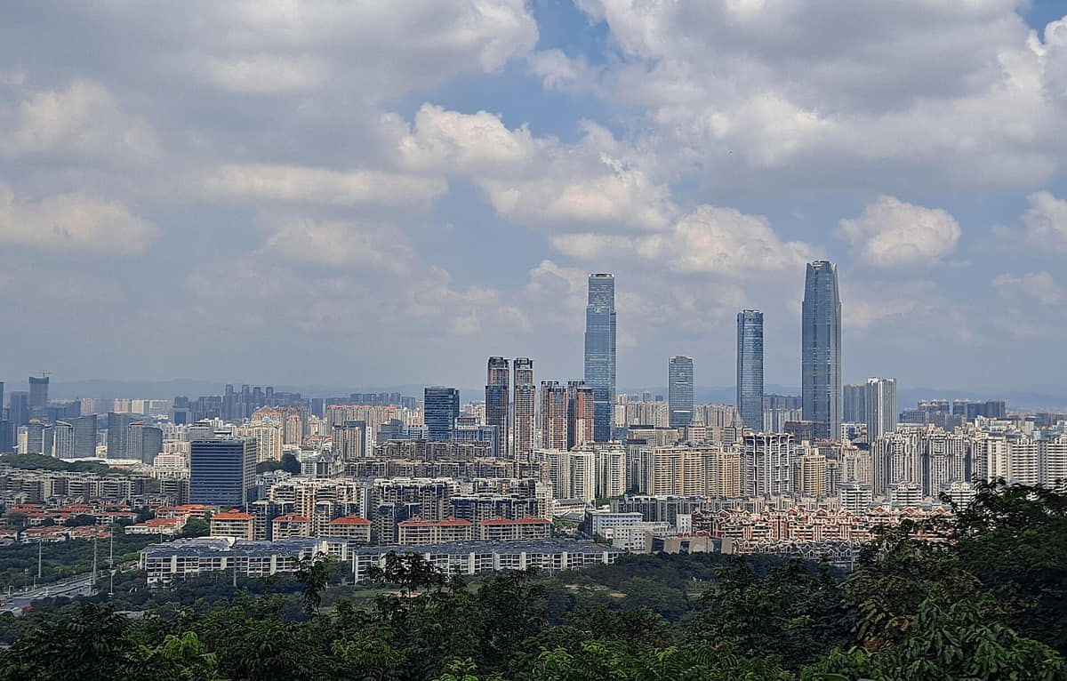
The core spans the Yong River and surrounding low hills; the municipality extends north and west into karst and basin counties, east toward Hengzhou, and through agricultural, forest, reservoir, market-town, and village landscapes.[1][2][3][4]
Yong River, tributaries, subtropical hills, karst edges, basins, farmland, and twelve county-level units define Nanning.
Yong River basin
The Yong River and tributaries organize the core through bridges, floodplains, levees, parks, ports, agriculture, and two-bank growth.[1][2][3][4]
Subtropical low hills
Rolling terrain, red soils, forests, orchards, reservoirs, karst edges, and warm wet conditions shape the wider municipality.[1][2][3][4]
County landscapes
Long'an, Mashan, Shanglin, Binyang, Hengzhou, and Wuming add karst, basins, rivers, farming, market towns, crafts, and different local cultures.[1][2][3][4]
Municipal scale
Seven districts, four counties, and one county-level city span the dense core, eastern and southern growth, river valleys, hills, farms, and villages.[1][2][3][4]
Permanent residents across all seven districts, four counties and the county-level city of Hengzhou in Nanning Municipality; do not mix with the six central districts, central built-up area, registered residents, commuters, students, railway or airport passengers, visitors, or wider regional-corridor estimates
Population figures use the administrative area and source date shown below.[5][6]
Climate
Humid subtropical monsoon climate
Winters are mild, summers long, hot, humid, and rainy, and tropical weather systems can bring heavy rain; vegetation remains prominent year-round.
Climate describes long-term seasonal patterns; live conditions appear separately.[6][27]
Long hot humid months bring heavy rain, thunderstorms, flooding, and tropical-system effects; follow official alerts.[1][2][3][4]
October–November
Autumn
Drier, less humid periods often suit river walks, Qingxiu Mountain, county markets, museums, and longer journeys.[1][2][3][4]
December–January
Winter
Generally mild but sometimes damp and cool; greenery remains prominent and outdoor exploration is often comfortable.[1][2][3][4]
A short history of the city
Eleven sourced layers move from river, basin and karst geography through archaeology, Yongzhou and walled-city formation, river trade, guild halls, outer settlements, modern roads and public institutions, disruption and rebuilding, multi-centre growth, and the exact end-2025 twelve-unit municipality.
Image credits and licenses
Shouldered stone shovel displayPhoto: Cangminzho · source · CC BY-SA 4.0
The Yong River, tributaries, alluvial ground, low hills, karst basins and seasonal rain shaped travel, fields, settlement and flood exposure long before the current municipality. Modern embankments and reservoirs must not be projected backward unchanged.[6][10]
Archaeological evidence
Shouldered stone shovels and other excavated material are interpreted through findspot, association, material study and museum catalogues. A display image conveys scale and form but cannot establish date or function by itself.[8][9]
Ancient to medieval layers
Nanning Museum organises ancient history through changing settlement and administrative layers. Later names and boundaries should not be projected onto earlier communities as if the present municipality had always existed.[8]
Medieval urban formation
The name Yongzhou, river crossing, government offices, markets and defensive works became important historical reference points. Surviving wall settings are partial, repaired evidence rather than a complete medieval city frozen in place.[8][10]
Commercial urban life
Water routes linked Nanning with county markets and wider Guangxi. Landing places, warehouses, temples, guild spaces and street commerce shifted with channels, regulation and transport technology.[10][7]
Late-imperial city
Xinhui Academy records organised merchant and migrant networks through a named building. Its roof craft and inscriptions are visible, while membership, finance, construction phases and repairs need archival evidence.[10][26]
Municipal plurality
River towns and villages developed their own street patterns, houses, markets, production and ritual life. Their history should not be reduced to an excursion from the central city or assumed identical across the municipality.[26][10]
Late nineteenth to early twentieth century
Road building, arcaded commerce, schools, theatres and civic facilities altered the old-city fabric. Three Streets and Two Alleys now contains surviving, repaired, reconstructed and commercially adapted layers that require address-level chronology.[10][8]
Twentieth-century change
War, institutional change, demolition, new construction, flood management and population movement altered buildings and neighbourhoods. Present appearance should never be presented as untouched continuity from a founding year.[8][9]
Late twentieth to twenty-first century
Qingxiu's civic and exhibition axis, Nanning East Station, Wuxiang and Liangqing cultural facilities added new centres while the old city and county seats remained lived-in and adapted.[6][25]
End of 2025
Nanning had 9.0166 million permanent residents across seven districts, four counties and Hengzhou at end-2025. That figure must not be mixed with the six central districts, built-up area, registered population, commuters, visitors or a wider regional corridor.[5][6]
People, language, and everyday rhythms
Eight perspectives describe 9.0166 million end-2025 permanent residents across twelve county-level units, with local, ethnic, linguistic, migration, climate, work and cultural-practice differences and an explicit rejection of one Nanning personality.
Population with an exact boundary
9.0166 million means permanent residents across all twelve county-level units at end-2025, not everyone present on a given day and not only the central built-up city.[5][6]
Twelve different local settings
Central riverbank neighbourhoods, Wuxiang towers, Wuming basin, Binyang towns, Hengzhou farms and the mountain counties produce different travel times, housing, work and local attachments.[10][26]
Communities are specific, not display categories
Zhuang, Han, Yao, Miao and other identities intersect with district, village, language, generation, occupation, education and migration; no ethnic label predicts one lifestyle.[12][15]
Multilingual daily life
Mandarin, Nanning and other Southwestern Mandarin varieties, Pinghua, Zhuang varieties and additional languages circulate differently through families, markets, schools, workplaces, performance and media.[19][16]
Migration has many directions
Long-established residents, county-to-city movement, students, traders, service workers, return migration and regional or international links create biographies with different degrees of mobility and belonging.[6][24]
Climate and river shape routines
Shade, covered streets, markets, parks, riverside walking and later evening activity respond to heat and rain, but they do not prove that every resident lives slowly or uses public space alike.[6][27]
Practitioners keep culture changing
Singers, opera performers, dragon makers, cooks, craft workers, conservators, museum staff, teachers, neighbourhood groups and learners reproduce traditions through work, revision and debate.[19][28]
No single Nanning personality
Labels such as relaxed, warm, green or open may describe selected narratives and spaces; they are interpretations, not measurable traits shared by more than nine million people.[5][12]
Culture and daily life
Image credits and licenses
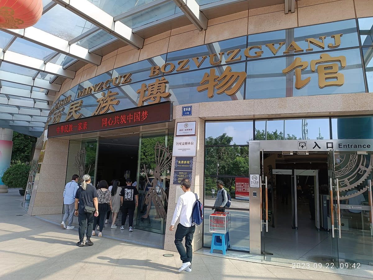
Anthropology Museum of Guangxi entrancePhoto: Nan Ning Huang Sokaz 12 · source · CC BY-SA 4.0
Large bronze-drum-shaped displayPhoto: Gary Todd · source · CC0
Zhuang-house museum displayPhoto: Gary Todd · source · CC0
Binyang firecracker-dragon museum scenePhoto: Cangminzho · source · CC BY-SA 4.0
2012 international folk-song festival performancePhoto: Marc Wathieu from Huy, Belgium · source · CC BY 2.0
Wuming Zhuang Sanyuesan
A safeguarded festival practice tied to specific communities, organisers, song gatherings and changing public programmes; it is not a timeless performance by all Zhuang people.[15][18]
Song gatherings and staged festivals
Village, district and municipal song contexts differ in language, repertoire, participation and amplification. A 2012 international stage should not stand in for community song transmission.[18][28]
Yong opera
A local theatre system of vocal styles, instruments, movement, martial technique, scripts, troupes, venues and audiences with circulation beyond Nanning.[16]
Binyang firecracker dragon
A place-specific festival combining dragon making, procession, sound, ritual, neighbourhood organisation and safety management; live practice is richer than a museum diorama.[14]
Zhuang brocade in regional context
A major Guangxi textile tradition with varied production centres and practitioners. Display or sale in Nanning does not make every textile Nanning-made or assign one design to all Zhuang communities.[17]
Bronze drums as objects and symbols
Archaeological drums, museum collections, replicas, monumental architecture, sound practice and contemporary symbolism are related but distinct evidence layers.[12][11]
Dwellings through museum interpretation
Stilt-house displays can explain structure and environment, but real houses vary by place, date, materials, household, repair and present use.[12]
Pinghua and county song traditions
Nanning Pinghua songs, Wuming Zhuang songs, Shanglin traditions and other practices depend on specific speakers, performers and safeguarding organisations rather than a single municipal sound.[19][28]
Guild halls and neighbourhood institutions
Guild halls, temples, academies, market associations and neighbourhood organisations historically supported trade, ritual, education, welfare and memory in different ways.[10]
Museums are not one source of provenance
Nanning Museum focuses on municipal history, Guangxi Museum collects province-wide history and art, and the Anthropology Museum researches regional cultures. Their buildings, collections and source communities must remain distinct.[8][11][12]
Contemporary international performance
China–ASEAN and other programmes bring visiting performers into Nanning. Cultural exchange is organised, selective and contemporary—not proof that every imported form has local historical roots.[24][18]
Living religious and ritual places
Temples, ancestral spaces and reconstructed ritual complexes can be heritage, active community places and managed visitor sites at once. Current etiquette and institutional guidance take priority.[25][27]
Food and local flavor
Fourteen entries treat Nanning food as a municipal system of rice-noodle production, fermentation, pickling, county products, household and festival practice, markets and regional circulation. Laoyou noodles, raw-pressed noodles, suanye, lemon duck and five-colour rice receive image-backed treatment, with explicit provenance, allergen and current-safety limits.
Star anise photographed in NanningPhoto: Walter Grassroot · source · CC0
Named local noodle family
Laoyou rice noodles
Fresh rice noodles, broth, fermented bamboo shoots, black beans, garlic, chili, sour notes and varied toppings form a recognised family, but the official standard does not make every bowl identical.[20][21]
Fermentation and pressing practice
Raw-pressed rice noodles
Rice batter or dough is fermented and pressed into noodles, with broth and toppings varying by producer and locality. Sour aroma, meat, stock and serving temperature require direct confirmation.[19][21]
Pickled fruit and vegetable family
Suanye
Mango, papaya, pineapple, cucumber, star fruit and other produce may be seasoned sweet, sour, salty or hot. Ingredients, brine, refrigeration and utensil hygiene differ stall by stall.[21][23]
Duck with preserved citrus and aromatics
Wuming lemon duck
Duck is cooked with preserved lemon or related citrus, ginger, garlic, chili and other aromatics in varying formulas. A railway photograph only illustrates one serving form.[22][21]
Festival and household food
Five-colour glutinous rice
Differently coloured rice portions are associated with plant-based dyes and festival or household practice, but plant sources, method and meaning vary. Colour alone does not prove a traditional dye.[20][19]
County product and scenting craft
Hengzhou jasmine tea
Jasmine growing, tea-base selection, repeated scenting, drying, grading and trade form a county-linked production system. A cup sold in central Nanning is not automatic proof of Hengzhou origin.[23][19]
Large wrapped-rice family
Hengzhou rice dumplings
Glutinous rice, beans, pork or other fillings are wrapped and cooked in locally varied forms. Size, filling, fat, salt, allergens and festival use differ by maker.[10][19]
Historic-town food craft
Yangmei fermented black beans and rice cakes
Named Yangmei practices connect fermentation, grain processing, household knowledge and small production. Heritage recognition never replaces current ingredient labels or hygiene checks.[19][26]
County livestock and restaurant practice
Mashan black-goat dishes
Goat may appear in soups, braises or grills linked to Mashan promotion, but breed, farm, cut, preparation, bones and food safety need confirmation at the venue.[23][21]
Production and distribution
Fresh rice noodles as infrastructure
Nanning's noodle variety depends on milling, water, fermentation, fresh distribution, market schedules and small shops. Product names do not reveal shelf life or safe storage.[20][6]
Flavour-building system
Sour, fermented and aromatic ingredients
Fermented bamboo shoots, black beans, preserved citrus, pickles, chili, garlic and star anise build different dishes. Similar aromas do not mean identical recipes or origins.[21][23]
Urban service rhythm
Markets and late meals
Wet markets, breakfast noodle shops, neighbourhood stalls and evening food streets serve different workers and districts. Opening, prices, crowds and hygiene are live, venue-specific information.[21][27]
Regional circulation
A wider Guangxi table in the capital
Restaurants and migrants bring foods from across Guangxi and beyond. Availability in Nanning proves circulation, not Nanning origin, and provincial museum or festival labels should not overwrite local makers.[23][10]
Practical food literacy
Reading menus and stalls safely
Ask about pork, duck, goat, fish, shellfish, peanuts, sesame, soy, wheat, egg, fermented ingredients, chili, stock, alcohol, herbs, refrigeration and cross-contact. Popularity, heritage status and an attractive photograph never guarantee suitability or current safety.[20][22][27]
Landmarks and architecture
Image credits and licenses
Yong River and an urban bridgePhoto: Sevgonlernassau · source · CC BY-SA 4.0
The primary orientation system joining old waterfronts, bridges, embankments, parks, port traces, southern growth and flood-management infrastructure; river and city should be read together.[6][10]
Qingxiu Mountain
A managed urban mountain and botanical landscape of ridges, reservoirs, specialised gardens, paths, ritual sites, views and recreation—not one untouched forest panorama.[13]
Longxiang Pagoda
A prominent Qingxiu Mountain tower whose present fabric, rebuilding history, inscriptions, landscape role and current access need to be read as separate layers.[13]
Three Streets and Two Alleys
A central historic district combining old lanes, arcaded and courtyard buildings, conserved remains, reconstruction, museums, residents, commerce and heavy visitor use.[10][26]
Old-city-wall setting
Partial conserved masonry embedded in the modern city; archaeological phase, repair, reconstructed elements and public landscaping must not be merged.[10]
Xinhui Academy
A named guild-hall building linking Guangdong merchant networks, Lingnan roof craft, inscriptions and later urban conservation.[10]
Yangmei historic town
A Yong River townscape whose lanes, houses, river relation, food crafts and lived community extend Nanning's history beyond the central districts.[26]
Nanning Museum
The municipal institution for archaeology, city history, folk song, ceramics and public interpretation; its object labels and exhibitions are stronger evidence than visual guesswork.[8][9]
Guangxi Museum
A province-wide history and art museum in Nanning. Its collections provide regional context while retaining provenance from across Guangxi and beyond.[11]
Anthropology Museum of Guangxi
A research and exhibition institution for Guangxi's diverse communities, best used as a sourced introduction before engaging specific living places and practitioners.[12]
Nanning Confucian Temple
A reconstructed ritual and educational complex where historical institution, rebuilt architecture, current public events and visitor management remain distinct.[25]
International Convention and Exhibition Center
Durable event infrastructure associated with China–ASEAN exhibitions; current fairs, access, security and participant lists are schedule-dependent.[24]
Guangxi Culture and Art Center
A contemporary multi-hall cultural venue in Liangqing whose architecture is durable while programmes, tickets and access remain live.[25]
Guangxi Minzu Theatre
A performance and research venue supporting changing theatre and music programmes; facade identity should not be confused with one permanent repertoire.[16][25]
Wuxiang and Liangqing new centre
High-rise offices, housing, cultural and sports facilities, roads and river crossings form a newer metropolitan centre that cannot be represented by one tower.[6][7]
Nanning East Railway Station
A major regional rail gateway linking municipal and wider movement; architecture is stable, but services, border procedures and passenger conditions are live.[6][27]
Wuming and northern county landscapes
Karst basins, reservoirs, fields, towns, villages and mountain routes demonstrate why a complete Nanning guide must include district and county geography beyond the central city.[15][26]
Ways to explore the city
Follow the Yong River, use museums for context, then choose a county-level direction to encounter the region at a more specific scale.
River and green city
Yong River → Qingxiu Mountain → neighborhood meal
Connect flood management, two-bank growth, subtropical ecology, public recreation, and everyday food.[1][2][3][4]
Regional cultures carefully
Anthropology Museum → community or festival context
Begin with sourced interpretation, then encounter living practices without treating any ethnic group as a static display.[1][2][3][4]
Capital to county
Central Nanning → Wuming, Hengzhou, Mashan, or another county
Choose one outer direction to compare basin, karst, river, agriculture, markets, language, and local festival calendars.[1][2][3][4]