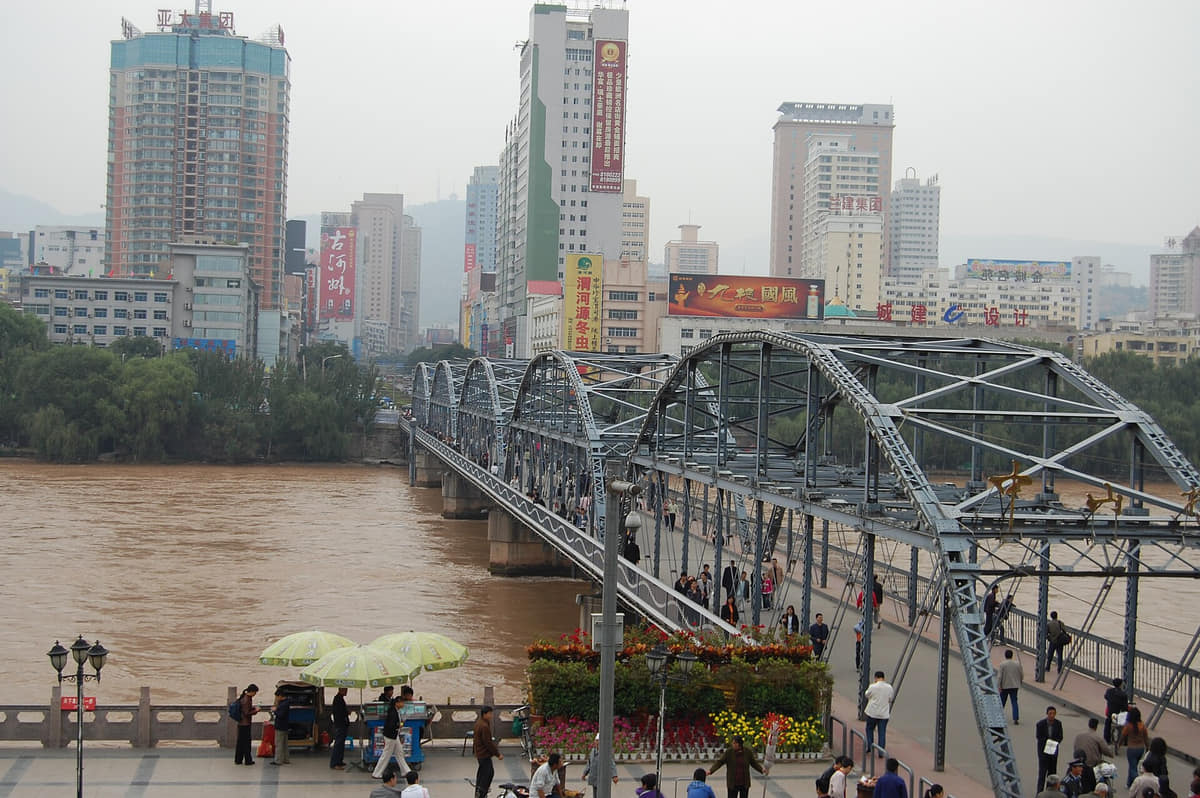
A narrow upper-Yellow-River capital where bridges, water engineering, Silk Road collections, industry, universities, multi-community life, precise breakfast culture, and dry mountains share one long corridor.
Yellow River corridor, Zhongshan Bridge, beef noodles, Gansu Provincial Museum, waterwheels, mountain slopes, industry, universities, and regional transport[1][2][3][4]
Guide scope
Eight county-level units spanning the narrow river core, eastern and western industrial corridors, university areas, mountain edges, farms, county towns, and outer valleys[1][2][3][4]
Understand Lanzhou as a river-valley cross-section
Lanzhou stretches along a narrow Yellow River valley between dry mountains. Limited flat land makes bridges, tunnels, rail, roads, water supply, flood management, and slope engineering essential to its east–west form.
The river image connects to much more: Gansu-wide museum collections, industrial and worker histories, universities, multi-community neighborhoods, county agriculture, mountain ecology, regional transport, and a highly specific everyday noodle system.
Lanzhou is a long, narrow river-valley municipality rather than a compact circular city. Bridges, tunnels, railways, hillside neighbourhoods, industrial land, irrigated terraces and county routes follow the Yellow River and its tributary valleys.
The Yellow River is both durable geography and live infrastructure. Water level, flood control, cableway and boat service, park access, air quality, dust, heat and winter conditions require current checks.
Narrow river metropolis
The Yellow River and dry mountains constrain growth into a long east–west corridor with repeated crossings.
Water in a dry climate
Supply, irrigation, industry, ecology, parks, flood control, and settlement all make river management central.
Routes and collections
Museums and transport corridors place Lanzhou within long-distance exchanges across Gansu and Eurasia.
Everyday precision
Beef-noodle technique, markets, commuting, industry, and neighborhood life balance the monumental river image.
A visual record of the city
Eighteen locally hosted, rights-cleared images cover the central city, outer municipal areas, institutions, transport, daily space and food context. Captions distinguish city evidence from regional references and live conditions.
The dense city follows an east–west river corridor between mountains; the municipality extends through industrial valleys, loess slopes, county seats, farms, villages, university areas, and mountain routes.[1][2][3][4]
A narrow Yellow River valley, dry mountain edges, loess terrain, limited flat land, and eight county-level units define Lanzhou.
Yellow River valley
The core stretches east–west along a narrow irrigated corridor between dry mountains, with limited flat land and repeated bridge crossings.[1][2][3][4]
Mountain edges
Loess slopes, gullies, terraces, dry mountains, erosion, greening projects, and hillside development frame the city.[1][2][3][4]
Water and aridity
The river supports settlement, irrigation, industry, parks, and supply in a dry climate, making water management central.[1][2][3][4]
Eight units
Five districts and three counties span the dense corridor, industrial valleys, university areas, airport-facing north, farms, county towns, and mountain villages.[1][2][3][4]
Population figures use the administrative area and source date shown below.[1][2][3][4][5]
Climate
Temperate semi-arid continental climate
Dry air, strong sun, windy springs, warm summers, cold winters, limited rainfall, and large day–night temperature ranges are shaped by the narrow valley and mountain terrain.
Climate describes long-term seasonal patterns; live conditions appear separately.[1][2][3][4][5]
Seasonal patterns
March–May
Spring
Wind, dust, dry air, fast warming, and strong sun make layers, hydration, and air-quality checks useful.[1][2][3][4]
June–August
Summer
Days are warm to hot but usually less humid; sun exposure, thunderstorms, flash flooding in gullies, and heat matter.[1][2][3][4]
September–November
Autumn
Clear dry periods and cool nights favor river walks, museum visits, county routes, and mountain views.[1][2][3][4]
December–February
Winter
Cold dry air, possible inversion pollution, ice, and short daylight make warm layers and current conditions important.[1][2][3][4]
A short history of the city
River crossings, long-distance routes, irrigation, bridge construction, industry, rail, universities, and contemporary regional transport form visible layers.
Lanzhou UniversityPhoto: Chen Zhao from Edinburgh · source · CC BY 2.0
River crossings and settlement
Archaeology, farming, herding, trade, and routes through the upper Yellow River valley supported long settlement.[1][2][3][4][5]
Frontier and route center
Administration, military systems, river crossings, irrigation, markets, religious institutions, and long-distance routes shaped the city.[1][2][3][4][5]
Bridge and modernization
Permanent bridge construction, roads, schools, industry, communications, and new institutions changed the valley city.[1][2][3][4][5]
Industrial expansion
Rail, petrochemicals, manufacturing, universities, housing, water systems, and migration extended the east–west corridor.[1][2][3][4][5]
Regional transport and service center
High-speed rail, metro, logistics, new districts, ecological work, services, museums, and county connections reshape the city.[1][2][3][4][5]
River crossing and regional exchange
Fords, ferries, walled settlements, temples, markets and routes connected the Hexi Corridor, Tibetan Plateau margins and central plains.[1][2][3][4][5]
Bridge and modern institutions
The iron bridge, schools, new administration, commerce and transport gave the river crossing a different urban scale.[1][2][3][4][5]
Industry and rail
Railways, factories, worker housing, research institutions and valley transport produced a major industrial and logistics layer.[1][2][3][4][5]
Multi-bank metropolitan growth
High-speed rail, metro, new bridges, ecological projects, hillside construction and county links connect both riverbanks and outer districts.[1][2][3][4][5]
People, language, and everyday rhythms
Residents include long-established neighborhoods, multiple ethnic and religious communities, students, industrial and service workers, traders, county residents, farmers, and migrants.
Language
Standard Mandarin is widely used; local speech belongs broadly to Lanzhou–Yinchuan Mandarin, alongside other languages carried by regional communities.[1][2][3][4][5]
Corridor city
Commuters, students, industrial workers, traders, service employees, logistics teams, county residents, and migrants share a long narrow metropolis.[1][2][3][4][5]
Multiple communities
Hui, Han, Dongxiang, Tibetan, Salar and other communities are present through specific neighborhoods, occupations, food traditions, institutions, and family histories.[1][2][3][4][5]
Avoiding one-image narratives
The Yellow River and noodles are important, but industry, universities, county agriculture, migration, environmental work, and ordinary neighborhoods are equally part of Lanzhou.[1][2][3][4][5]
Valley routines
Commuters cross bridges and tunnels between narrow terraces; university, industrial, market, rail and county communities experience the city differently.[1][2][3][4][5]
Multi-community daily life
Han, Hui, Tibetan, Dongxiang and other residents contribute distinct languages, faiths, trades and food practices; no resident should be inferred from appearance.[1][2][3][4][5]
Irrigation, waterwheels, bridges, boats, flood control, river terraces, parks, and public memory connect engineering with culture.[1][2][3][4][5]
Silk Road collections
Museums and research connect objects from across Gansu with trade routes, archaeology, religion, art, language, conservation, and changing interpretation.[1][2][3][4][5]
Multi-community urban life
Mosques, temples, markets, schools, restaurants, neighborhoods, workplaces, and family networks show varied identities in everyday settings.[1][2][3][4][5]
Performance
Qinqiang opera, folk forms, music, storytelling, contemporary theater, live venues, and media address different audiences.[1][2][3][4][5]
Industrial heritage
Rail, petrochemical and manufacturing sites, worker neighborhoods, engineering education, pollution control, and adaptive reuse form a modern cultural layer.[1][2][3][4][5]
County traditions
Yongdeng, Gaolan, Yuzhong and outer districts add farming, temple fairs, food, craft, mountain landscapes, and town life.[1][2][3][4][5]
Yellow River public realm
Bridges, embankments, parks, sculptures, waterwheels and overlooks make the river a shared civic landscape as well as infrastructure.[1][2][3][4][5]
University and research city
Lanzhou University and other institutes connect arid-region science, medicine, history, literature and regional education.[1][2][3][4][5]
Religious and community places
Mosques, Buddhist and Daoist sites, churches and community institutions require site-specific histories and respectful visitor behaviour.[1][2][3][4][5]
Performance and craft
Qinqiang, local opera, music, paper-cutting, carving, calligraphy and contemporary arts circulate through venues, schools and households.[1][2][3][4][5]
Food and local flavor
Beef noodles, cold wheat foods, mutton, fermented grains, breads, market snacks, and dishes from across Gansu shape a precise and varied table.
Clear broth, hand-pulled noodles in chosen widths, radish, chile oil, herbs, beef, and fast service define a precise local format.[1][2][3][4][5]
Cold wheat snack
Niangpizi
Steamed wheat sheets or gluten, chile, vinegar, garlic, sesame, vegetables, and shop styles make a cooling market food.[1][2][3][4][5]
Shared meat dish
Hand-grabbed mutton
Mutton, careful cooking, simple seasoning, bread or staples, tea, and communal service reflect wider northwest food traditions.[1][2][3][4][5]
Seasonal drink-dessert
Sweet fermented grains
Fermented grain, cool liquid, sweetness, texture, summer service, and household or stall variation create a distinctive refreshment.[1][2][3][4][5]
Market formats
Roast and baked foods
Flatbreads, buns, skewers, offal, potatoes, spices, ovens, and late-night stalls reflect corridor exchange and urban routines.[1][2][3][4][5]
Provincial capital
Gansu table
Foods from Linxia, Tianshui, Longnan, Hexi, Gannan and other areas circulate through markets, campuses, neighborhoods, and restaurants.[1][2][3][4][5]
A shop system, not one bowl
Lanzhou beef noodles
Broth, hand-pulled noodle width, beef, radish, herbs, chilli oil, queueing and breakfast rhythm vary by shop.[1][2][3][4][5]
Cold wheat preparation
Niangpizi stalls and texture
Wheat starch sheets, gluten, vinegar, garlic, chilli and vendor seasoning form a cool snack with variable texture and allergens.[1][2][3][4][5]
Sweet legume bowl
Grey-bean soup
Peas or beans, sugar and shop technique make a thick local sweet; recipe and sweetness vary.[1][2][3][4][5]
Fermented cereal snack
Sweet fermented grain service
Barley or other grains, fermentation time, temperature and serving style vary; alcohol and food-safety questions need vendor information.[1][2][3][4][5]
Northwest market food
Mutton and offal
Cuts, sourcing, halal practice, seasoning and cooking differ among households and restaurants.[1][2][3][4][5]
Dated commercial scenes
Night-market variety
Skewers, noodles, breads, fruit, sweets and migrant cuisines coexist. A 2018 photograph cannot identify today's stalls or standards.[1][2][3][4][5]
Landmarks and architecture
Image credits and licenses
White Pagoda MountainPhoto: Gary Todd from Xinzheng, China · source · CC0
Yellow River overlookPhoto: Gary Todd from Xinzheng, China · source · CC0
View from Five Springs ParkPhoto: ElectricLemon · source · CC BY 3.0
Zhongshan Bridge
A permanent crossing that makes river engineering, trade, transport, mountain-river form, public memory, and tourism visible.[1][2][3][4][5]
Gansu Provincial Museum
A starting point for Silk Road routes, provincial archaeology, fossils, art, craft, research, conservation, and interpretation.[1][2][3][4][5]
White Pagoda Mountain
A northern slope where religious architecture, paths, erosion control, greening, city views, river crossings, and recreation meet.[1][2][3][4][5]
Waterwheel Park
A curated riverfront site that helps explain historic irrigation technology while requiring distinction between reconstruction and original use.[1][2][3][4][5]
Yellow River waterfront
Bridges, levees, parks, water supply, flood systems, transport, skyline, recreation, and pollution management form the urban spine.[1][2][3][4][5]
County and mountain routes
Yuzhong, Yongdeng, Gaolan, mountain valleys, farms, towns, religious sites, and ecological projects expand the guide beyond the corridor core.[1][2][3][4][5]
White Pagoda Mountain landscape
A north-bank landmark and overlook connecting topography, temples, paths, vegetation and river views.[1][2][3][4][5]
Yellow River Mother
A modern public sculpture whose civic meaning and riverfront setting should be separated from ancient-history claims.[1][2][3][4][5]
Lanzhou University
A modern education and research landscape embedded in the dense eastern urban valley.[1][2][3][4][5]
Lanzhou West Station
A high-speed rail gateway linking the long valley city with wider regional networks; operations are live information.[1][2][3][4][5]
Five Springs Park
A hillside park where springs, temples, paths, trees, recreation and city views meet.[1][2][3][4][5]
Yellow River Tower
A contemporary riverfront landmark and interpretation venue; current exhibitions and access require confirmation.[1][2][3][4][5]
Ways to explore the city
Read one river cross-section, connect breakfast with museum collections, then compare the dense corridor with an outer county route.
River cross-section
White Pagoda Mountain → Zhongshan Bridge → south-bank streets
Move from slope to bridge to commercial city while reading river width, limited flat land, public space, and east–west form.[1][2][3][4]
Museum and breakfast
Beef-noodle shop → Gansu Provincial Museum → riverfront
Connect everyday technique with documented provincial routes, objects, and the modern river city.[1][2][3][4]
Beyond the corridor
Central Lanzhou → Yuzhong, Yongdeng, or Gaolan
Compare the dense valley with county agriculture, mountain routes, university areas, industrial sites, towns, and ecological conditions.[1][2][3][4]