
Temple and capital
Historic religious centers and modern regional institutions occupy the same city.
Inner Mongolia Autonomous Region · North China
A regional capital at the foot of the Daqing Mountains where temple-city history, multiple communities, museums, foodways, and contemporary growth meet.
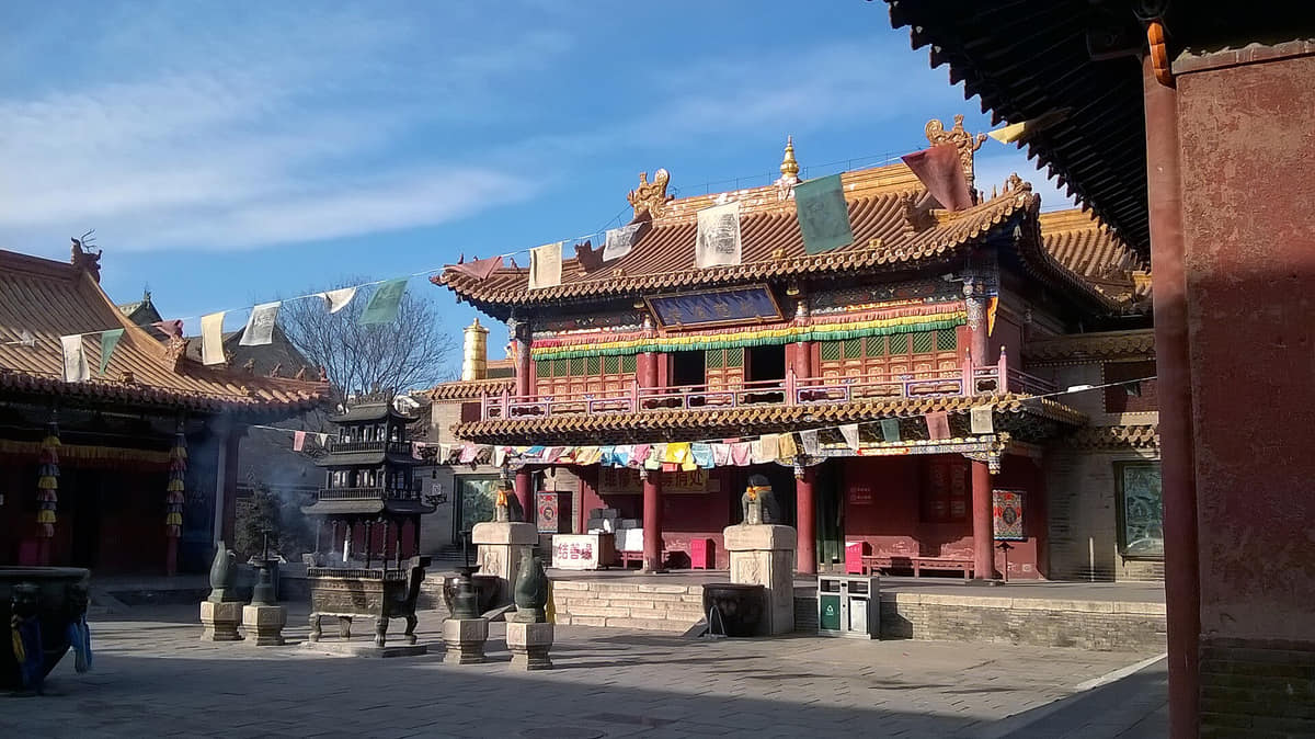
Hohhot sits where the Daqingshan section of the Yinshan range meets the Tumed plain. Its urban core is only one part of a much larger municipality that extends through four districts, one banner and four counties toward farmland, mountain valleys and the Yellow River landscape; a city-center photograph should never stand in for the entire municipal area.
The 2025 statistical bulletin records 3.661 million permanent residents, including 3.015 million urban and 646,000 rural residents, with an urbanization rate of 82.4 percent. These figures describe the full nine-unit municipality at year end, not only the contiguous built-up area or a cultural community.
Hohhot has a temperate continental climate: winters are long, cold and dry; summers are short and warm with concentrated rainfall; spring is dry and often windy; autumn is brief, cool and sunny. July and August together account for about half of annual precipitation and July averages about 22°C in the cited climate profile. These are long-term patterns, not a live forecast.
This guide treats Hohhot as a layered municipality rather than a slogan: archaeological evidence, restored buildings, living temples and mosques, museum interpretation, dated streets, industrial sites, county agriculture and documented meals are labelled separately. Current opening, worship, transport, weather, food safety and accessibility always require a live check.
Historic religious centers and modern regional institutions occupy the same city.
Daqing Mountains and Tumochuan Plain explain settlement and climate.
Language, food, music, work, and neighborhood life resist a single ethnic stereotype.
Mutton, dairy, grain, tea, and vegetables reflect pastoral, agricultural, and urban systems.
Twenty-seven locally hosted, rights-cleared images connect living temples and a mosque, Liao and Qing heritage, museums, rail and metro, old streets, mountains, county agriculture, dairy production and documented meals. Every caption separates visible evidence from historic interpretation, restoration, current access and dated conditions.
The built-up capital lies on the plain below the Daqing Mountains, while the municipality extends through counties and Tumed Left Banner toward agricultural and pastoral landscapes.[1][2][3][4]
Mountain front, dry continental climate, the Tumochuan Plain, and a mixed urban–rural municipality define Hohhot's setting.
Hohhot lies south of the Daqing Mountains on the northern edge of the Tumochuan Plain.[1][2][3][4]
Distance from the ocean, elevation, wind, and strong seasonality produce a relatively dry climate.[1][2][3][4]
The municipality includes dense districts, agricultural counties, a banner, foothill settlements, and grassland-edge landscapes.[1][2][3][4]
Rail and road links connect Hohhot with the Yellow River corridor, central Inner Mongolia, northern grasslands, and cities farther east and west.[1][2][3][4]
Loading current conditions…
Forecast data: Open-MeteoPermanent residents across Hohhot's nine county-level units
Population figures use the administrative area and source date shown below.[5]Winters are long, cold, dry, and windy; summers are shorter and warmer, with most rainfall concentrated from June to August.
Climate describes long-term seasonal patterns; live conditions appear separately.[1][2][3][4]Wind, dry air, dust, and rapid temperature changes make eye protection, hydration, and layers practical.[1][2][3][4]
Warm days, cooler nights, and most annual rainfall support urban and rural exploration, but storms can be sudden.[1][2][3][4]
Clear air, strong light, and rapid cooling create good visibility; nights become cold early.[1][2][3][4]
Long, cold, dry weather, wind, and heating dominate; outdoor visits need serious cold protection.[1][2][3][4]
Eleven evidence-led layers move from Dayao archaeology and the mountain–plain route system through Zhaojun memory, Fengzhou and the White Pagoda, the late-sixteenth-century Tumed city, Qing twin-city institutions, modern transport and today's nine-unit municipality.
Stone-tool evidence from the Dayao archaeological area is used by Hohhot museums to discuss human activity roughly half a million years ago. It establishes deep archaeology in the wider municipality, not an unbroken half-million-year history for today's city or population.[11]
A Han-period diplomatic marriage associated with Wang Zhaojun became the basis for centuries of literature and commemoration. Today's mound, museum, sculpture and exhibitions are later memorial and interpretive layers; their appearance does not by itself prove burial contents or every detail of the historical narrative.[10][11]
Official local heritage records place the octagonal White Pagoda at the northwest corner of Fengzhou old city and date its construction broadly to the reign of Liao Emperor Shengzong, 983–1031. The standing monument includes later repairs and visitor works, so material phases require conservation evidence.[8]
White Pagoda inscriptions recorded in several scripts—including Chinese, Khitan, Jurchen, Uighur-Mongolian, Phags-pa, Syriac and Persian—show that later users and travelers left a multilingual archive. Script identification is evidence of contact; it does not reveal every writer's identity or intent without specialist reading.[8]
In the late sixteenth century, Tumed ruler Altan Khan's urban project and the construction of Dazhao reshaped the settlement later known as Guihua. The official Dazhao record gives 1579 as the temple's starting date and 1640 for a major rebuilding; the present precinct contains later fabric and uses.[7]
Dazhao, Xilitu Zhao and other institutions became part of a landscape of worship, learning, workshops, markets and travel. Temple architecture is important evidence, but living ritual, commercial streets and reconstructed visitor districts must be described as separate contemporary systems.[7][11]
The Qing period added Suiyuan city and official compounds to the older Guihua landscape. The former General's Office and Princess Mansion preserve museum-presented courtyards associated with administration and elite residence, while restoration and present exhibitions are later layers.[9][10]
Long-distance trade, neighborhood institutions, schools and rail transport altered the city from the late nineteenth into the twentieth century. Dated photographs help compare streets and gateways, but they cannot establish today's businesses, population mix or surviving historic fabric.[1][11]
Housing, public institutions, manufacturing, food processing, education and services expanded the urban area and connected it more tightly to surrounding counties. This was uneven and should be studied through dated statistics, plans, oral history and material evidence rather than a single story of progress.[1][11]
Today's municipality joins four urban districts, Tumed Left Banner and four counties through rail, metro, roads, universities, museums, dairy processing, agriculture, services and ecological management. The 2025 population is a municipal total, while county and district experiences remain distinct.[5][1][13]
Eight perspectives describe 3.661 million permanent residents through statistical scope, language, mobility, food and logistics work, education, county life, heritage labor and environmental change—without assigning one identity or personality to everyone.
The 2025 year-end figure covers the entire municipality: 3.015 million urban residents and 646,000 rural residents. It is a statistical residence measure, not a count of one ethnicity, language, neighborhood or visitor population.[5][1][6][10][13]
Mandarin Chinese, Mongolian and local speech varieties are visible or audible in different institutions and settings, alongside residents from many backgrounds. Language use changes by family, generation, education and situation; no one language or identity describes every resident.[5][1][6][10][13]
Railway stations, metro, buses, roads, walking and cycling connect the four urban districts, but travel time and accessibility vary. County and banner journeys can be much longer, and a 2026 platform photograph is not a live service guide.[5][1][6][10][13]
Dairy processing, restaurants, markets, agriculture, transport, retail and logistics link urban demand with Horinger, Wuchuan, Tumed Left Banner, Togtoh and other county areas. Brand reputation or an old factory photo cannot substitute for current labor, safety and supply-chain evidence.[5][1][6][10][13]
Universities, schools, hospitals, research bodies, museums and public services bring students, specialists and visitors into the city. Institutions have different missions and access rules; their buildings do not by themselves measure educational quality or public inclusion.[5][1][6][10][13]
Dense urban neighborhoods, industrial and university areas, plain agriculture, mountain settlements and Yellow River communities exist within one municipal boundary. Their housing, transport, work and services differ, so a central-city profile must not erase county-scale life.[5][1][6][10][13]
Monastics, mosque communities, conservators, museum staff, musicians, craftspeople, cooks, guides and cleaners sustain cultural places in different ways. Heritage belongs to ongoing labor and negotiation, not only to photogenic facades or festival performances.[5][1][6][10][13]
Cold winters, windy springs, summer rain, urban growth, migration and environmental management shape everyday choices. Residents respond differently by age, income, job, housing and health; this guide avoids assigning a single personality to the city.[5][1][6][10][13]
Fourteen entries move from milk tea, lamb shaomai and sheep-meat kitchens to dairy, grain, county supply, industrial processing, dietary communication, traceability, labor and live safety checks.
Milk tea may be served with fried millet, dairy foods, breads, meat or other accompaniments, making it part of a meal system rather than only a beverage. Salt, dairy base, thickness and additions vary by household and venue; the gallery shows one regional serving.[12][13][7]
Hohhot's lamb shaomai are commonly discussed with brick tea and breakfast or daytime tea-shop routines. Dough, filling, fat, seasoning, vinegar and order-by-weight conventions vary; one 2018 steamer photograph is documentation, not a standard specification.[12][13][7]
Lamb and mutton appear through boiling, roasting, stewing, offal soup and hot pot, each with different cuts, textures and social settings. Ask about broth, organ meat, spice and portion size instead of treating all sheep-meat dishes as interchangeable.[12][13][7]
Milk, yogurt, cream, butter, cheese-like curds and dried milk foods differ in process, sugar, salt and texture. Traditional terminology and industrial brands overlap but are not identical; lactose, milk-protein allergy and cold-chain needs should be checked.[12][13][7]
Dry-fried grain can accompany milk tea or be eaten with dairy additions, but grain species, toasting, crushing and serving vary. The photographed bowl is a regional example and should not be used to define every product sold as chaomi.[12][13][7]
Oats, millet, buckwheat and wheat support noodles, steamed rolls, pancakes and other county and urban foods. Names and shapes travel across northern China and Inner Mongolia, so origin claims need evidence and local preparations should be described precisely.[12][13][7]
Offal soup combines selected sheep organs, broth, aromatics and optional starches or breads, with major shop-to-shop variation. Diners should ask which organs and stock are used and whether chili, coriander or shared utensils can be adjusted.[12][13][7]
Mongolian-style pies, buns, flatbreads and fried dough appear around markets, old-city streets and family tables. Labels can describe shape and filling, but should not turn one shop's product into a universal ethnic recipe.[12][13][7]
Wuchuan potatoes, plain agriculture and livestock-related supply chains connect county land with urban kitchens. A 2004 flowering field confirms one historical landscape only; current acreage, variety, yield, certification and farm practice need current data.[12][13][7]
Horinger became strongly associated with large-scale dairy processing and related logistics. The gallery's 2004 factory exterior is not evidence of current ownership, production, welfare, labor or environmental performance; company and regulator records should be checked.[12][13][7]
Shaomai-and-tea venues can function as places for breakfast, conversation and regular social contact. This is a recurring urban practice, not proof that all residents eat the same breakfast or that a dated old-city photograph is a current venue guide.[12][13][7]
Commercial streets, food festivals and brands amplify local reputation and can help visitors discover dishes. Promotion, awards and heritage labels do not automatically certify authenticity, health value, ingredient origin, price fairness or present quality.[12][13][7]
A mosque or neighborhood style does not certify every nearby restaurant. Ask the venue directly about halal practice, pork or alcohol contact, wheat, dairy, nuts, sesame, meat stock and shared fryers or utensils; requirements differ by diner.[12][13][7]
Meat, dairy, offal, cooked grains and takeaway foods depend on sourcing, cold chain, holding temperature, cleaning and worker practice. Use current inspection information and visible conditions; a beautiful plate, famous name or old factory image is not a food-safety certificate.[12][13][7]
Use temple history, museum context, and mountain–plain geography as complementary routes into Hohhot.
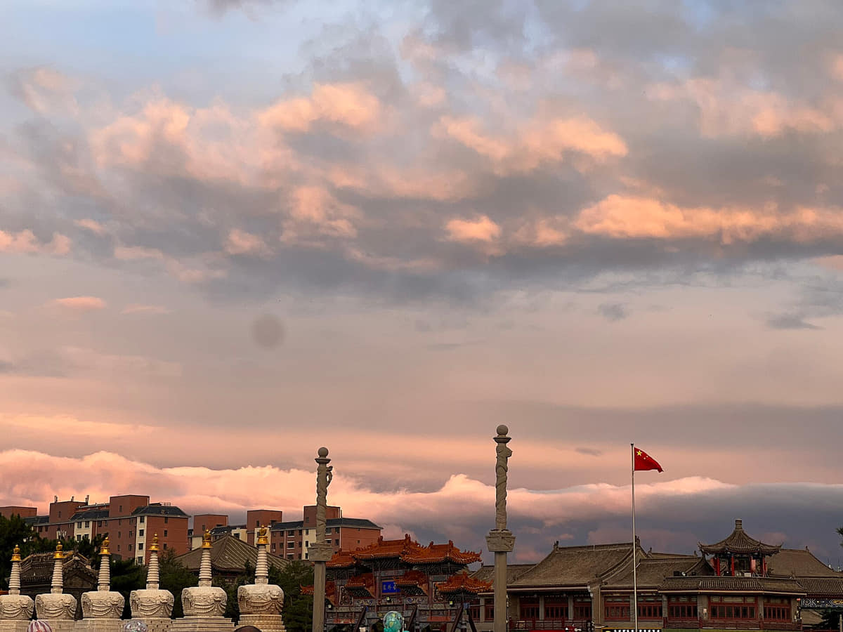
Historic religious complexes explain the old city's foundation, trade, art, neighborhood form, and long connections across the steppe and agricultural frontier.
Read the story