
Land and water
This city-specific topic connects place, daily life, and the wider municipal landscape: Land and water.
Sichuan Province · Sichuan Province, Southwest China
A northern Sichuan gateway where the ancient Shu Roads, Jianmen Pass, cliff sculpture, river valleys, mountain forests, old towns, and transport corridors remain visible together.
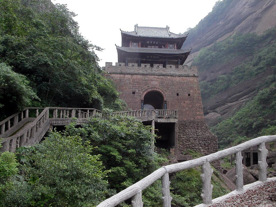
Guangyuan sits where the Jialing River and mountain corridors cross the northern edge of the Sichuan Basin. Three districts and four counties extend from the central confluence through Zhaohua and Jiange to Chaotian, Qingchuan, Wangcang, and Cangxi, with large differences in terrain, travel time, climate, work, and public services.
The Shu Road is not one gate or a Three Kingdoms costume set. It is a long material system of paths, paving, bridges, ferries, post stations, towns, trees, cliff roads, retaining works, inscriptions, temples, maintenance labor, stories, and later roads and railways occupying related terrain.
Guangyuan also contains nationally important cliff sculpture, Zhaohua's living townscape, Jialing River transport memory, Maliu embroidery, county agriculture, reservoir communities, and Tangjiahe's research-led biodiversity protection. These subjects require different evidence and cannot be collapsed into a single 'gateway' brand.
A complete exploration therefore separates geology from reconstructed architecture, history from legend, sculpture from souvenir imagery, protected habitat from wildlife spectacle, and documented local food from generic Sichuan dishes—while reconnecting each subject to workers, residents, regulation, maintenance, safety, and county landscapes.
This city-specific topic connects place, daily life, and the wider municipal landscape: Land and water.
This city-specific topic connects place, daily life, and the wider municipal landscape: Historical layers.
This city-specific topic connects place, daily life, and the wider municipal landscape: Living culture.
This city-specific topic connects place, daily life, and the wider municipal landscape: County diversity.
Eighteen rights-cleared local images connect Jianmen geology and reconstructed gateways, maintained Shu Road segments, Mingyue Gorge transport layers, Huangze and Thousand-Buddha Cliff conservation, Zhaohua, Qingchuan and Cangxi landscapes, Tangjiahe ecology, and the modern railway corridor.
This city-specific topic connects place, daily life, and the wider municipal landscape: Qinling–Daba transition.[1][2][3][4]
Four geographic relationships define Guangyuan.
This city-specific topic connects place, daily life, and the wider municipal landscape: Qinling–Daba transition.[1][2][3][4]
This city-specific topic connects place, daily life, and the wider municipal landscape: Jialing River corridor.[1][2][3][4]
This city-specific topic connects place, daily life, and the wider municipal landscape: Mountain passes and valleys.[1][2][3][4]
This city-specific topic connects place, daily life, and the wider municipal landscape: Seven county-level units.[1][2][3][4]
Loading current conditions…
Forecast data: Open-MeteoPermanent residents across Guangyuan Municipality
Population figures use the administrative area and source date shown below.[1][2][3][4]Warm valleys, cool mountains, concentrated summer rain, and frequent cloud reflect the northern basin gateway.
Climate describes long-term seasonal patterns; live conditions appear separately.[1][2][3][4]Temperatures rise quickly; rain, cloud, and local elevation call for flexible outdoor plans in Guangyuan.[1][2][3][4]
Warm valleys, cool mountains, concentrated summer rain, and frequent cloud reflect the northern basin gateway.[1][2][3][4]
Clearer intervals and cooler evenings usually favor river, old-town, museum, and county routes.[1][2][3][4]
Damp cool conditions make layered clothing and indoor–outdoor route pairing practical.[1][2][3][4]
Nine evidence-led layers move from early river-and-route settlement through imperial roads, cliff carving, pass administration, towns and ferries, modern rail, municipal formation, heritage law, and national-park conservation.
Zhaohua, Jiange, Chaotian, Cangxi, and other county landscapes linked river shipping with overland movement, education, ritual, forestry, agriculture, craft, and market exchange. The corridor contained many local timelines rather than one continuous highway.[6][15]
The Baoji–Chengdu Railway reused the broad northern corridor while introducing tunnels, bridges, electrification, stations, worker communities, slope engineering, and new logistics. Guangyuan became a prefecture-level city in 1985 amid wider administrative and urban change.[10][6]
High-speed rail, highways, logistics, city renewal, reservoir management, agriculture, heritage laws, grotto monitoring, trail tourism, national-park science, community livelihoods, flood and slope safety, and county services now intersect. Tradeoffs remain visible.[7][16][2]
Six perspectives center language, route labor, grotto conservation, forest research, craft and food work, and the different daily geographies of seven county-level units.
Southwestern Mandarin and Standard Mandarin are widespread, with local variation across river valleys, mountain towns, and Sichuan–Shaanxi–Gansu connections. Vocabulary, accent, migration, age, schooling, and household history shape speech more than a fixed 'northern Sichuan' label.[6][2]
Pavers, bridge builders, boat crews, ferrymen, innkeepers, porters, railway workers, drivers, station staff, engineers, maintenance teams, slope monitors, and vendors transformed difficult terrain into movement. Celebrated travelers depended on less visible labor.[10][15]
Archaeologists, art historians, geologists, hydrologists, conservators, photographers, digital technicians, guides, security staff, cleaners, and local residents care for cliff sites. Conservation is collaborative work rather than cosmetic restoration.[13][14]
Tangjiahe depends on rangers, field researchers, data workers, educators, veterinarians, drivers, community partners, and residents. Wildlife images are produced within monitoring, safety, access, and disturbance rules, not by guaranteed encounters.[16][17]
Maliu embroiderers, tofu makers, noodle-shop teams, farmers, orchard workers, tea processors, mushroom growers, fishers and aquaculture workers, market vendors, cooks, delivery workers, and inspectors connect heritage and food to livelihoods.[18][21]
Lizhou, Zhaohua, Chaotian, Wangcang, Qingchuan, Jiange, and Cangxi differ in elevation, transport, industry, agriculture, hazard exposure, schools, healthcare, dialect detail, tourism pressure, and links beyond Guangyuan. Municipal totals contain distinct lives.[2][1]
Twelve entries place steamed rice noodles, Jianmen tofu, county dishes, fruit, walnuts, tea, mushrooms, river food, preservation, banquets, markets, and home meals within technique, labor, regulation, and landscape.
Rice slurry is steamed in thin sheets, cooled or rested, cut, placed over bean sprouts, and dressed with garlic water, soy seasoning, vinegar, chile oil, and shop-specific additions. Rice, water, steaming, knife work, holding time, cleanliness, and queue speed define quality.[19][21]
Soybean selection, soaking, grinding, filtering, boiling, coagulation, curd handling, pressing, water quality, temperature, yield, texture, sanitation, and same-day use create tofu suitable for many techniques. Geographic stories do not replace production records.[20][19]
Frying, braising, steaming, simmering, quick-frying, soup, cold dressing, dried tofu, stuffed forms, and modern presentation demonstrate versatility. Menu names may draw on route stories, but taste, technique, labor, nutrition, allergens, price, and waste still matter.[20][19]
Traceable pork intestine requires repeated cleaning, blanching, careful braising, spice balance, fat and texture control, holding temperature, kitchen separation, and safe service. Shop methods and pairings vary; intensity should not mask preparation quality.[21]
Cultivated and lawfully gathered fungi, vegetables, cured foods, tofu, meat, broth, and other ingredients may share a heated pot. Species identification, harvest legality, traceability, ventilation, fuel safety, cross-contamination, cooking order, and leftovers are essential.[21]
Cultivar, rootstock, pollination, pruning, soil, water, frost, heat, pests, harvest maturity, gentle handling, grading, cold chain, labeling, storage, processing, labor, and market price determine fruit quality beyond a cut-open color.[22][21]
Tree variety, slope, orchard management, harvest, drying, shelling, rancidity control, storage, grinding or chopping, dough, sweetness, baking, allergens, packaging, and shelf life connect the nut harvest with a portable local snack.[22][21]
Elevation, cultivar, shade, soil, plucking season, withering, heat treatment, rolling, drying, grading, storage, water, brewing, labor, and market access shape products sold under names such as Micangshan and Qifo tea.[21][22]
Species identification, protected-species rules, seasonal fishing restrictions, aquaculture or purchase records, water quality, cold chain, freshness, bones, kitchen separation, cooking temperature, and waste control come before claims of wild or ecological fish.[21][15]
Salt, brine, drying, smoking, fermentation, jars, airflow, temperature, time, cleanliness, meat source, nitrite control, labeling, refrigeration, and cooking vary by household, workshop, elevation, and season.[21][6]
Purchasing, butchery, soaking, steaming, frying, braising, stove management, borrowed equipment, reciprocal labor, seating, serving order, dietary needs, leftovers, cost, water, waste, and food safety shape large meals more than a fixed dish count.[21][7]
Breakfast stalls, produce markets, school and factory canteens, family kitchens, county restaurants, noodles, rice, vegetables, tofu, soups, tea, delivery, price, opening hours, nutrition, allergies, and accessibility describe daily eating more fully than a signature-food list.[19][2]
Three routes pair the core city with contrasting county-level landscapes.
At Guangyuan, paths, passes, rivers, carved cliffs, inns, armies, traders, and today's railways occupy related terrain.
Read the story