
Where is Dazhou in China?
Dazhou is in northeastern Sichuan Province, where the Qu River system meets routes through the Daba Mountains toward Chongqing, Shaanxi and Hubei.
Sichuan Province · Sichuan Province, Southwest China
Dazhou is an eastern Sichuan city shaped by the Qu River, Daba Mountain routes, rare Han watchtowers, natural-gas industry and seven distinct county-level units. This guide connects its map, history, food, weather and main sights.
Dazhou is a seven-unit municipality, not one urban center. Tongchuan District contains the principal civic, riverfront, bridge, market, and railway core; Dachuan District adds the Zhou River, Shiqiao historic street, farms, towns, and expanding urban edges. Xuanhan reaches the Daba Mountain south slope and Luojiaba archaeology; Kaijiang contains cultivated valleys and Renshi's ceramic archway; Dazhu combines county-town life, bamboo and ramie production, orchards, and villages; Qu County holds Chengba archaeology, a nationally significant Han-tower network, and Sanhui's pagoda and industrial fabric; Wanyuan rises into steep ridges, terraces, cloud, river settlements, and mountain agriculture. The county-level map is essential to understanding the city.
The Daba Mountain south slope, parallel ridges, basin-edge hills, and the Qu–Zhou river system organize settlement, agriculture, transport, ecology, and risk. Dazhou's humid subtropical monsoon climate generally brings hot humid valley summers, cloudy mild winters at lower elevations, concentrated rain, fog, and cooler mountain gradients. A climate description is not live weather: temperature, rain, river level, visibility, landslide risk, rail and road conditions, and attraction access require current checks.
Dazhou's identity is layered: Luojiaba and Chengba archaeology; Han funerary towers and historic carving; river crossings, market towns, farms, bamboo, ramie, orchards, and food processing; mountain households and flood recovery; rail, road, aviation, gas, coal, chemicals, logistics, and service work; museums, archives, conservation, environmental monitoring, schools, hospitals, and contemporary public life. No single label—ancient Ba culture, gas city, railway hub, or mountain city—can describe all seven units.
This guide treats every statistic, place, image, recipe, and story as dated evidence. Promotional population claims are not used when a newer statistical bulletin provides a defined permanent-resident figure. An image title may describe a cycling journey while the frame shows trains; a workshop's former industry may be unknown; an old street may combine surviving, repaired, and rebuilt fabric; a famous product varies by maker. Observation, source claim, interpretation, current operation, and uncertainty are separated, stereotypes are avoided, and no political position is adopted.
Dazhou is in northeastern Sichuan Province, where the Qu River system meets routes through the Daba Mountains toward Chongqing, Shaanxi and Hubei.
Dazhou is known for the Qu County Han funerary towers, Luojiaba and Chengba archaeology, mountain-and-river landscapes, rail links, natural gas and a seven-unit municipality.
Dengying beef is the best-known name, alongside fermented mash, Qu County daylily, cured meat, bamboo shoots and mountain produce. Product origin, preparation and food safety still need venue-level checks.
This city-specific topic connects place, daily life, and the wider municipal landscape: Land and water.
This city-specific topic connects place, daily life, and the wider municipal landscape: Historical layers.
This city-specific topic connects place, daily life, and the wider municipal landscape: Living culture.
This city-specific topic connects place, daily life, and the wider municipal landscape: County diversity.
Twenty-seven rights-cleared, visually audited records cover all seven county-level units: Tongchuan riverfront and rail, Dachuan river and Shiqiao, Xuanhan mountain rail, Kaijiang's Renshi archway, Dazhu town and villages, Qu County Han towers and Sanhui, Wanyuan terraces and flood recovery, plus a community market. Captions distinguish current, archival, dated, and uncertain evidence.
This city-specific topic connects place, daily life, and the wider municipal landscape: Qu River system.[1][2][3][4]
Four geographic relationships define Dazhou.
This city-specific topic connects place, daily life, and the wider municipal landscape: Qu River system.[1][2][3][4]
This city-specific topic connects place, daily life, and the wider municipal landscape: Daba Mountain south slope.[1][2][3][4]
This city-specific topic connects place, daily life, and the wider municipal landscape: Eastern transport gateway.[1][2][3][4]
This city-specific topic connects place, daily life, and the wider municipal landscape: Seven county-level units.[1][2][3][4]
Loading current conditions…
Forecast data: Open-MeteoPermanent residents across Dazhou Municipality
Population figures use the administrative area and source date shown below.[5]Basin-edge valleys are hot and humid while northern mountains are cooler, wetter, and prone to intense rain.
Climate describes long-term seasonal patterns; live conditions appear separately.[1][2][3][4]Temperatures rise quickly; rain, cloud, and local elevation call for flexible outdoor plans in Dazhou.[1][2][3][4]
Basin-edge valleys are hot and humid while northern mountains are cooler, wetter, and prone to intense rain.[1][2][3][4]
Clearer intervals and cooler evenings usually favor river, old-town, museum, and county routes.[1][2][3][4]
Damp cool conditions make layered clothing and indoor–outdoor route pairing practical.[1][2][3][4]
Nine evidence-led layers move from early settlement through Luojiaba and Chengba archaeology, Han funerary towers, changing routes and counties, late-imperial towns, modern institutions, rail and industry, dated documentary records, and contemporary stewardship.
Long-term settlement developed around tributary valleys, river terraces, springs, caves, ridgeline passes, fertile pockets, fishing, hunting, farming, and exchange routes. Archaeological layers, objects, burials, plant and animal remains, dating, disturbance, and environmental change must be established site by site; today's administrative borders and ethnic labels cannot be projected unchanged into deep history.[7][8]
Luojiaba in Xuanhan and Chengba in Qu County preserve settlement and burial evidence central to research on societies conventionally discussed within Ba-region archaeology. Bronze, pottery, tomb form, spatial organization, chronology, craft, exchange, diet, status, and later disturbance require excavation reports and continuing study. Archaeological labels are analytical tools, not simple equivalents of a timeless modern identity.[7][9]
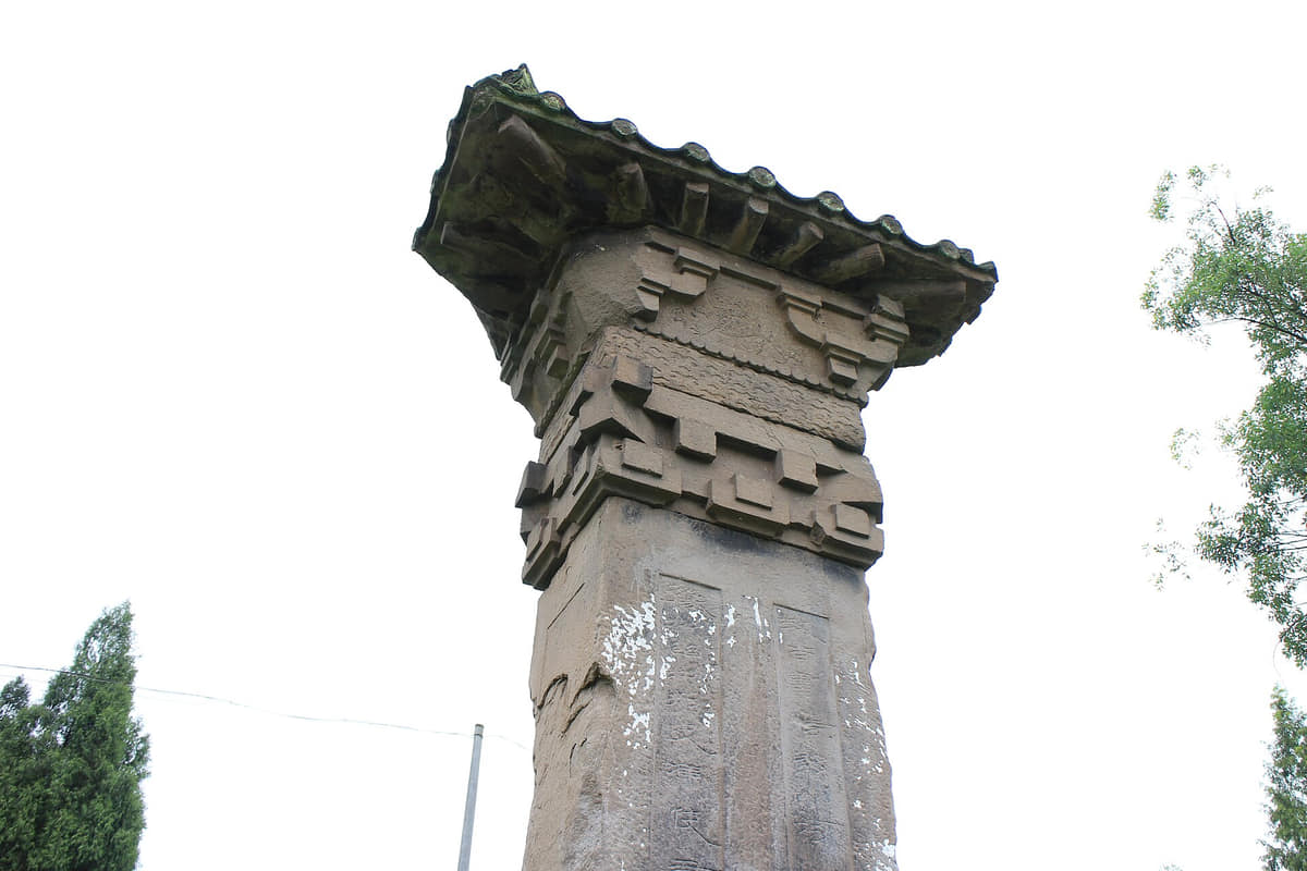
Qu County's surviving stone que belong to funerary approaches that once connected tombs, roads, patrons, inscriptions, carved architecture, human and animal imagery, stone extraction, transport, and specialist labor. The towers should be compared through inscriptions, form, tool marks, archival photographs, displaced components, landscape setting, conservation history, and structural monitoring—not treated as isolated scenic props.[8][9]
County and prefectural names, seats, jurisdictions, roads, ferries, granaries, schools, temples, markets, taxation, military and postal routes, farming, water control, and links toward Shaanxi, Chongqing, and neighboring Sichuan changed repeatedly. Named routes such as the litchi and Micang corridors require segment-level evidence; a modern municipality is not a fixed ancient unit.[7][12]
Renshi's ceramic archway, Sanhui's Wenfeng Pagoda, Shiqiao's carved archways and timber streets, river crossings, market lanes, halls, temples, workshops, and homes belong to distinct local chronologies. Patronage, inscriptions, construction technology, rebuilding, religious or educational meaning, commerce, fire, flood, repair, and current use must be documented element by element.[8][12]
River and overland trade, new roads and postal systems, schools, public health, administrative institutions, workshops, mining, migration, printed media, performance, and changing land relations affected county towns and villages unevenly. Archives, family records, buildings, objects, maps, newspapers, oral accounts, and later restorations need source criticism and separate dates.[7][8]
Railways, mines, natural-gas and coal extraction, chemical and materials industries, factories, roads, bridges, power and water systems, housing, schools, hospitals, markets, and new districts changed work, travel time, migration, land use, pollution exposure, and settlement form. Construction, operation, closure, remediation, occupational health, and worker memory require separate evidence.[5][6][12]
The image archive makes change visible at different scales: Qu towers in 1914; Dazhu and Wanyuan streets and villages around 2009–2011; Hekou rebuilding after a flood; and Dazhou station in 2023. These photographs are observations with authors, frames, omissions, and dates. They must be compared with maps, archives, interviews, surveys, and newer images rather than treated as timeless truth.[8][6]
Contemporary Dazhou simultaneously manages archaeological sites, Han towers, old streets and pagodas, museums and archives, river and forest systems, farmland, flood and slope risk, rail and road infrastructure, aviation, energy and industry, tourism, schools, health care, markets, waste, accessibility, and seven local administrations. An approved plan, completed project, active service, visitor claim, and measured cultural, social, or environmental outcome are not interchangeable evidence.[5][9][12]
Six perspectives center language and seven local contexts; farm, river, and market labor; rail, gas, mining, industry, and infrastructure; food, fiber, building, and services; knowledge and conservation work; and unequal household mobility rather than a single city personality.
Southwestern Mandarin varieties, Standard Mandarin, occupational vocabulary, school and media use, migration, age, household, and county differences coexist. A Tongchuan vendor, Dachuan farmer, Xuanhan rail worker, Kaijiang craft conservator, Dazhu ramie producer, Qu County archaeologist, or Wanyuan mountain resident cannot be reduced to one city personality.[11][6]
Rice, corn, potatoes, oil crops, vegetables, daylily, toon, orchards, tea, poultry, livestock, bamboo, ramie, irrigation, boats, fisheries under current rules, stalls, storage, transport, processing, sanitation, flood response, and household care connect mountain villages with county towns and urban consumers. Season, land, water, gender, age, price, mechanization, and risk shape different lives.[5][10]
Train operation, track and signal maintenance, freight, road transport, aviation, gas and coal extraction, chemicals, materials, construction, engineering inspection, equipment repair, power, water, logistics, safety, rescue, and environmental remediation shape the municipality. Institutional histories should include workers, contractors, occupational health, families, closures, retraining, and changing technology.[5][7]
Beef processors, cooks, noodle and fermented-mash makers, tea growers, poultry raisers, produce vendors, bamboo and ramie workers, carpenters, masons, stone carvers, builders, drivers, guides, cleaners, delivery workers, carers, and small businesses hold practical knowledge. Maker attribution, training, labor conditions, safety, price, adaptation, and current demand matter more than calling any practice timeless.[10][8]
Archaeologists, conservators, museum registrars, archivists, historians, teachers, librarians, geologists, foresters, weather observers, water monitors, planners, emergency responders, medical staff, accessibility workers, market inspectors, sanitation crews, and maintenance teams produce and care for the evidence and services behind this guide. Methods, uncertainty, budgets, safety, and long-term monitoring deserve visibility.[5][9]
Permanent residents, registered residents, students, commuters, migrants, returnees, older adults, children, disabled people, caregivers, entrepreneurs, renters, homeowners, and visitors experience Dazhou differently. City-center renewal, county-town growth, village aging, mountain access, disaster recovery, education, health care, housing, digital services, and regional mobility create gains and burdens that cannot be summarized by one average.[5][11]
Twelve entries place Dengying beef, fermented mash, daylily, cured meat, bamboo shoots, river fish, toon, goose and duck, selenium tea, mountain potatoes, chile and chicken, daily meals, and the complete food system within sourcing, technique, labor, safety, season, labeling, and maker variation.
Document the beef's legal source and inspection, cut, trimming, slicing thickness, possible curing, cooking or frying, chile, Sichuan pepper, oil, salt, sugar, texture, cooling, packaging, shelf life, allergens, sodium, maker, and whether the sample is fresh or packaged. The name describes a product family, not one universal recipe.[10]
Rice variety and source, soaking, steaming, cooling, starter composition, inoculation, vessel sanitation, fermentation temperature and time, acidity, sweetness, alcohol content, water, refrigeration, packaging, shelf life, serving temperature, added egg or fruit, and maker variation should be stated. Fermented does not mean risk-free or alcohol-free.[10]
Name the cultivated daylily product and lot, field source, flower stage, harvest labor, drying method, sulfur treatment where legally used and declared, moisture, storage, mold and pest control, rehydration, trimming, thorough cooking, traceability, and producer. Fresh and dried forms require different safety handling; unknown ornamental lilies must never be substituted.[10]
Species and cut, legal slaughter and inspection, cure formula, salt and nitrite control, smoke source and exposure, drying weather or controlled environment, time, pests, mold assessment, storage temperature, slicing, cooking, fat and sodium, vulnerable diners, packaging, and maker attribution matter. An old-house image does not prove a food sample's safety or origin.[10]
Identify the bamboo species, cultivated or permitted source, season, shoot age, land and harvest rules, peeling, washing, slicing, blanching or repeated water changes where required, cooking, storage, contamination, packaging, allergies or intolerance, grower income, and ecological effects. Unknown wild shoots should not be eaten from a generic recommendation.[10][5]
Record species, legal farmed or permitted market source, current fishing and closed-season rules, size, traceability, cold chain, cleaning, bones, parasite control, cooking temperature, chile or pickling where used, allergens, sodium, raw–cooked separation, water ecology, and advisories. A river photograph is not proof that restaurant fish was locally caught.[5][12]
Document cultivar or species identification, orchard or field source, harvest stage and season, washing, sorting, blanching and cooking practice, portion, nitrate and nitrite management through freshness and handling, cold storage, allergens or intolerance, traceability, and grower. Unknown leaves should never be gathered because they resemble toon.[10]
Breed or production line, farm and feed, animal health and welfare, legal slaughter and inspection, whole-bird or cut processing, brining, roasting, braising, drying or packaging where applicable, cooking temperature, bones, fat, sodium, cold chain, shelf life, traceability, allergens, and maker variation must be described product by product.[10][5]
Tea cultivar, named garden and elevation, soil and water, harvest date and leaf standard, pesticide compliance, withering, fixation, rolling, drying, storage, brewing, caffeine, sensory profile, traceability, and maker matter. Any selenium claim should refer to product-level testing and legal labeling; it must not become an unverified disease-prevention or treatment claim.[10]
Potato variety, field, greening and sprouting control, storage and cooking; chile cultivar, drying, mold and heat; and chicken breed verification, farm, feed, animal health, legal slaughter, cold chain, cooking temperature, bones, and traceability are separate evidence chains. A regional list does not guarantee every item in every shop is local or certified.[10]
Breakfast noodles, rice and grain dishes, greens, roots, beans, tofu, eggs, meat, soups, fruit, tea, school and work canteens, hospital meals, takeaway, season, price, nutrition, household labor, allergies, religion, medical needs, time, age, and preference describe daily food better than a list of famous products.[5][6]
Fields, tea gardens, orchards, livestock farms, slaughter, workshops, factories, wholesalers, wet and dry markets, homes, restaurants, canteens, cold storage, water, sanitation, ventilation, inspections, worker conditions, accessibility, affordability, delivery, packaging, leftovers, composting, wastewater, and refuse collection complete Dazhou's food story.[5][10]
Three routes pair the core city with contrasting county-level landscapes.
The surviving stone towers connect elite tombs, roads, carving workshops, imperial administration, local materials, and modern preservation.
Read the story