Changsha, China, is the capital of Hunan Province. The Xiang River connects Yuelu learning, Mawangdui archaeology, contemporary culture and nine distinct county-level units across the municipality.
Xiang River, Yuelu Academy, Mawangdui, Hunan Museum, Orange Isle, spicy food, media, nightlife, advanced manufacturing, and county traditions[1][2][3][4]
Guide scope
Nine county-level units spanning the river core, Yuelu hills, eastern airport-industrial corridor, Wangcheng and Changsha County, Liuyang, Ningxiang, towns, and rural landscapes[1][2][3][4]
Changsha, China city guide: Hunan capital, Xiang River and Yuelu
Changsha is organized by the Xiang River, Yuelu Mountain and a nine-unit municipality extending far beyond the central nightlife districts. Six urban districts, Changsha County, Liuyang and Ningxiang contain river islands, old streets, campuses, manufacturing corridors, towns, farmland, kiln landscapes and archaeological sites.
Its deepest local evidence comes from several different archives: Mawangdui tomb objects, Zoumalou documents, Tongguan kiln ceramics, Tanheli archaeology and the institutional history of Yuelu Academy. Museum display, excavation place, reconstructed architecture and written tradition must remain separate.
Contemporary Changsha combines a provincial capital's universities, museums, media, services and transport with county manufacturing, ceramics, fireworks culture and food supply. These systems create different schedules and identities rather than one simple ‘entertainment city’ personality.
The page uses dated images as documentary records, not live claims. Weather, river stage, openings, train services, crowding, water quality, event legality and food safety require current official or venue-level information.
Quick answers
Where is Changsha?
Changsha is the capital of Hunan Province in south-central China. The Xiang River organizes a nine-unit municipality that includes six urban districts, Changsha County, Liuyang and Ningxiang.
What is Changsha known for?
Changsha is known for Yuelu Academy, Mawangdui archaeology, Orange Isle, Hunan Museum, media and creative industries, spicy Hunan food and county traditions such as Liuyang fireworks.
Xiang River metropolis
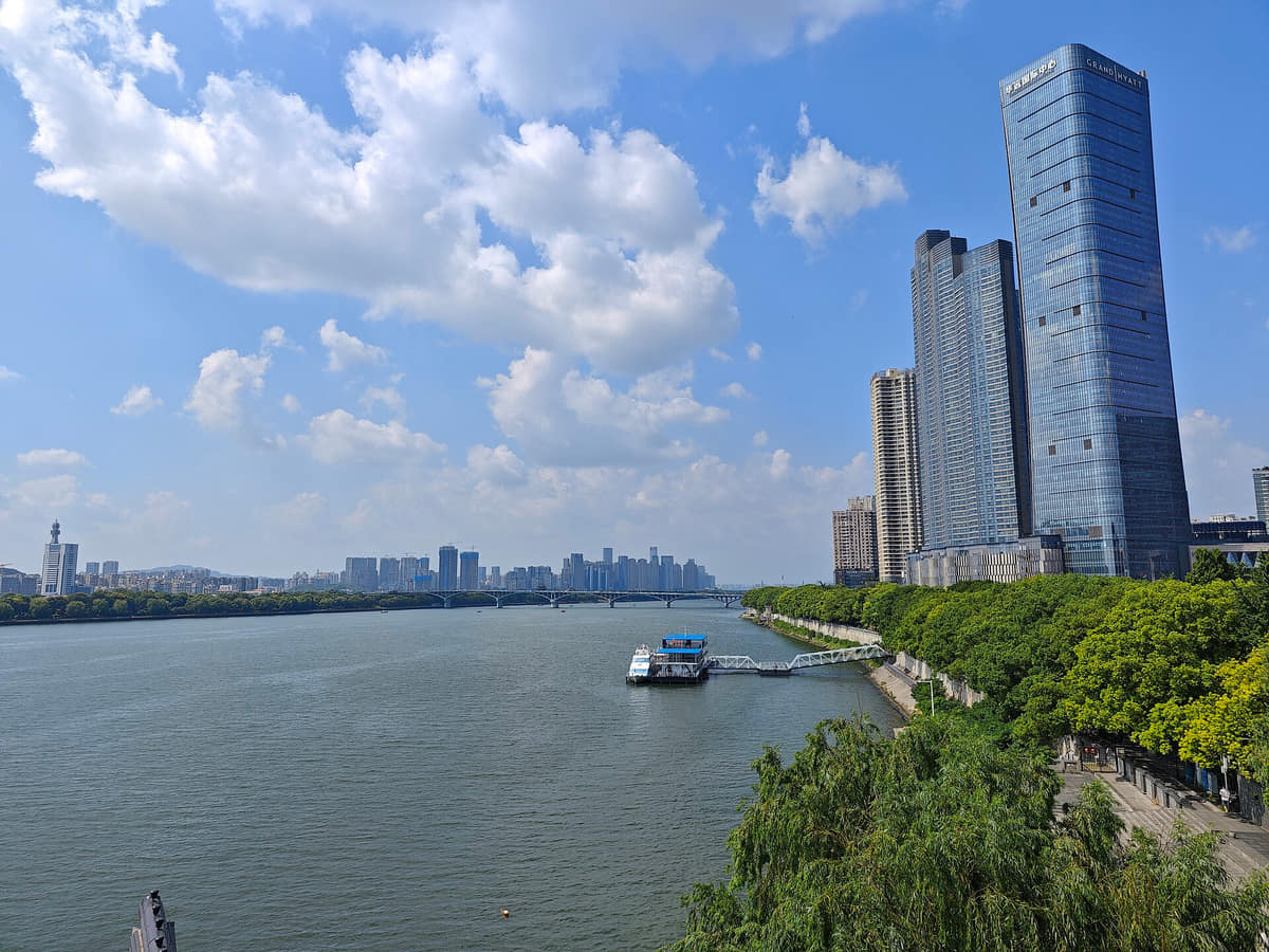
River, islands, bridges, flood management, and two-bank development explain urban form.
Learning across time
Academy, university, museum, publishing, and media show changing knowledge institutions.
Mawangdui material world
Archaeology reveals textiles, food, medicine, texts, belief, craft, and conservation.
Visible contemporary culture
Food, nightlife, music, television, digital media, and tourism intensify the city's public image.
A visual record of the city
Twenty-seven locally hosted, rights-cleared images connect the Xiang River core with Yuelu learning, Mawangdui and Wu-slip archaeology, Tongguan ceramics, reconstructed and living heritage, county landscapes in Wangcheng, Changsha County, Liuyang and Ningxiang, contemporary architecture, transport and four distinct food contexts. Every caption separates visible evidence from provenance, reconstruction, current status and commercial claims.
The core spans the Xiang River between the older east bank and Yuelu west bank; the municipality extends east through airport and manufacturing corridors and outward into Liuyang, Ningxiang, river valleys, hills, towns, and villages.[1][2][3][4]
The Xiang River, islands, Yuelu hills, basin plain, county valleys, and nine-unit municipality define Changsha.
Xiang River axis
The river, islands, tributaries, bridges, levees, and two-bank development organize the metropolitan core.[1][2][3][4]
Hills and basins
Yuelu Mountain and surrounding low hills interrupt the basin plain, shaping views, ecology, campuses, temples, and reservoirs.[1][2][3][4]
County landscapes
Liuyang, Ningxiang, Changsha County, and Wangcheng add rivers, hills, agriculture, manufacturing, towns, villages, and archaeological sites.[1][2][3][4]
Municipal scale
Six districts, one county, and two county-level cities span the dense core, airport-industrial east, river plains, outer hills, and rural settlements.[1][2][3][4]
Permanent residents across all nine county-level units of Changsha Municipality; do not mix with the central built-up-area population, registered residents, students, railway or airport passengers, visitors, or wider Changsha–Zhuzhou–Xiangtan estimates
Population figures use the administrative area and source date shown below.[5][35]
Climate
Humid subtropical monsoon climate
Summers are long, hot, humid, and rainy; winters can be damp and cool, with frequent spring rain and clearer autumn periods.
Climate describes long-term seasonal patterns; live conditions appear separately.[6][7]
Seasonal patterns
March–May
Spring
Frequent rain, rapid warming, and high humidity reward rain planning, layered clothing, and flexible mountain or river routes.[1][2][3][4]
June–August
Summer
Long hot humid periods and thunderstorms favor early starts, shade, museums, evening walks, and official heat or rain alerts.[1][2][3][4]
September–November
Autumn
Drier, clearer weather suits Yuelu Mountain, Xiang River walks, county sites, museums, and longer cross-city journeys.[1][2][3][4]
December–February
Winter
Cool damp spells and occasional cold snaps pair well with museums, food routes, bookshops, and shorter outdoor sections.[1][2][3][4]
A short history of the city
Eleven sourced layers move from Tanheli and the Xiang basin through Mawangdui, Tongguan ceramics, Yuelu Academy and Zoumalou documents to old-city change, twentieth-century loss and rebuilding, provincial institutions and a contemporary nine-unit metropolis.
Image credits and licenses
Mawangdui lacquer platePhoto: Huangdan2060 · source · CC BY 3.0
Ningxiang archaeology places the wider municipality inside Bronze Age settlement and exchange histories; museum interpretation and the excavated site remain distinct.[20][13]
River routes and settlement
The Xiang basin connected agriculture, craft, transport and changing regional centers over long periods rather than beginning with one modern city date.[6][13]
Changsha kingdom and Mawangdui
The tombs excavated in 1972–1974 preserve unusually rich evidence for elite material life, texts, medicine, food, textiles and funerary practice.[11][12]
Tongguan kiln production
Large kiln landscapes in present-day Wangcheng connect ceramic technology, decoration, river transport and long-distance exchange.[18][19]
Yuelu Academy
The academy's institutional history begins in the Northern Song and continues through repeated rebuilding, teaching change and its relationship with Hunan University.[8][9]
Learning, temples, markets and river commerce
Academies, religious institutions, administrative functions, market streets and river movement built overlapping urban systems.[6][34]
Zoumalou Wu slips
More than 100,000 excavated slips and tablets transformed the study of local administration and everyday transactions; discovery date and document date are not the same.[15][16]
Old-city fabric and new institutions
Walls, streets, schools, printing, commerce and transport were repeatedly adapted; current historic blocks contain original, repaired and newly interpreted layers.[13][32]
Conflict, loss and rebuilding
War, fire, reconstruction, education, industry and transport reshaped the city. Surviving wall fabric and reconstructed pavilions must be dated separately.[6][13]
Provincial institutions and metropolitan systems
Universities, museums, manufacturing, broadcasting, roads and rail strengthened Changsha's role as a provincial center.[7][33]
Nine-unit river metropolis
Metro expansion, high-speed rail, new cultural buildings and county integration accelerated growth while archaeology, old streets and living heritage required continuing protection.[5][35][33]
People, language, and everyday rhythms
Eight perspectives describe 10.7214 million end-2025 permanent residents through exact municipality-wide scope, nine distinct local settings, river and hill routines, learning, creative work, speech variation, labor and an explicit rejection of one city personality.
Population scope
The end-2025 figure of 10.7214 million is a permanent-resident count for all nine county-level units, not the central built-up area, registered population, students, passengers or visitors.[5][35]
Nine local contexts
Six districts, Changsha County, Liuyang and Ningxiang include old neighborhoods, campuses, new centers, industrial zones, towns, farms, kiln sites and mountain-edge settlements.[35][34]
River and hill routines
Bridges, metro lines, embankments, islands and Yuelu slopes produce different walking, commuting, exercise and leisure patterns.[6][30]
Students and scholars
Universities, Yuelu Academy, libraries, laboratories and museums sustain large learning and research communities beyond visitor-facing heritage.[8][10]
Media, design and performance
Broadcasting, publishing, digital platforms, music, theatre and cultural venues create visible creative work, but they represent only one part of the labor market.[33][22]
Speech and language
Standard Mandarin is widely used alongside local Xiang speech and county variation; age, family history, education and mobility prevent one accent from representing everyone.[6][24]
Work across the municipality
Manufacturing, logistics, education, medicine, commerce, food service, construction, technology, farming, ceramics and public services follow different schedules.[5][33]
Avoiding one city personality
Spicy food, humor, nightlife and media are real public images, but more than ten million residents cannot be reduced to one temperament, lifestyle or consumer scene.[5][34]
Liuyang fireworks displayPhoto: Haluk Comertel · source · CC BY 3.0
Mawangdui material culture
Lacquer, textiles, manuscripts, food remains, medical knowledge and funerary objects require object-by-object provenance and conservation reading.[11][10]
Yuelu learning landscape
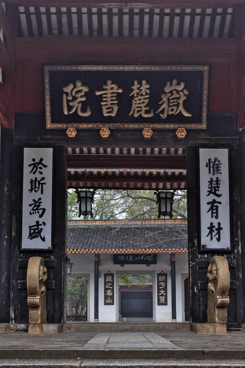
Courtyards, inscriptions, lectures, texts, university teaching and mountain paths connect a long institutional history with present education.[8][9]
Zoumalou document culture
Excavation, decipherment, conservation and digital or museum interpretation turn administrative fragments into evidence for everyday history.[15][14]
Tongguan ceramics
Clay, glaze, painted decoration, kiln technology, river transport and exchange networks belong to one production landscape rather than a single souvenir style.[17][19]
Xiang embroidery
Design, drawing, thread, stitch, workshop training, conservation and contemporary markets keep a demanding craft active.[23][21]
Xiang Opera
Vocal systems, role types, repertory, companies, teachers and audiences form a living stage tradition distinct from one tourism show.[21][22]
Flower-drum opera
Regional variants, comic and dramatic repertory, music, performers and community stages broaden Hunan performance beyond one metropolitan venue.[25][22]
Changsha tanci and storytelling
Voice, rhythmic narration, local speech, memory, apprenticeship and small audiences sustain an intimate verbal art.[24][23]
Living religious institutions
Temple architecture, worship, community use, festivals, collections and visitor behavior are related but should remain respectfully distinct.[32][34]
Liuyang fireworks craft
Historical craft knowledge and public performance are important cultural layers, while present manufacturing, storage, transport, display, safety, legality and environmental impact require current regulation.[26][27]
Xiang River public culture
Islands, bridges, embankments, running, cycling, viewing, flood memory and commuting make water a shared civic system.[30][6]
Contemporary cultural production
Museums, universities, broadcasting, digital media, music, design and new arts buildings add current production to inherited culture without replacing it.[33][21]
Food and local flavor
Fourteen entries treat Changsha food as a breakfast, snack, household, county and night-service system: stinky tofu, rice noodles, tangyou baba, buns, pig blood, jelly, pancakes, stir-fries, Liuyang practices and regional circulation, ending with explicit menu-safety guidance. Images are servings, not origin proof or universal recipes.
Dark fermented tofu is fried and dressed or filled with broth, chili, garlic and aromatics; fermentation and shop recipes differ.[28][29]
Breakfast staple
Changsha rice noodles
Fresh rice noodles appear in soup or mixed forms with changing meat toppings, pickles, egg, scallion and chili.[28]
Sweet glutinous-rice snack
Tangyou baba
Fried glutinous-rice pieces are coated in a sweet syrup; shape, crispness, oil and sweetness vary by maker.[28]
Savory quick meal
Lard-mixed noodles
Rendered fat, seasoning, aromatics and noodles create a simple but shop-specific bowl whose ingredients should be checked directly.[28]
Filled steamed buns
Deyuan buns
Dough, meat or sweet fillings, proofing, steaming and portion define multiple named buns rather than one universal recipe.[28]
Hot savory snack
Sesame-oil pig blood
Pig blood, broth, sesame oil, pepper and garnishes form one local snack category; animal ingredients and handling require explicit confirmation.[28]
Cool starch snack
Shaved jelly
Soft starch jelly is cut or shaved and seasoned with chili, vinegar, garlic and other condiments in many proportions.[28]
Fried dough snack
Scallion pancake
Flour or rice-based dough, scallion, salt and hot oil produce versions that vary in thickness, crispness and fat.[28]
Market sweets
Sweet dumplings and grain snacks
Named sweets and grain snacks vary in dough, syrup, filling and frying; a list records circulation, not a fixed citywide formula.[28]
Regional home and restaurant cooking
Chili-and-meat stir-fries
Fresh chilies, sliced meat, garlic and fermented seasonings appear in many Hunan tables; one photograph cannot prove a Changsha origin or canonical recipe.[28][33]
County food traditions
Liuyang steamed dishes and fermented soybeans
Steaming, preserved ingredients and fermented soybeans link household practice, workshops and county supply chains without forming one menu.[29][27]
Metropolitan gathering
County and provincial table
Ningxiang, Liuyang, Dongting-area, western Hunan and other regional foods circulate through the capital alongside migrant cuisines.[34][29]
Urban service system
Night-market eating
Late opening, small portions, delivery, queues, social media and neighborhood restaurants make food highly visible, but popularity is not evidence of heritage or quality.[33][28]
Practical food literacy
Reading a menu safely
Ask about soy, sesame, peanuts, wheat, egg, pork, shellfish, alcohol, chili, cooking oil and cross-contact; heritage status never guarantees current food safety or dietary suitability.[29][28]
The main orientation system: river, long island, bridges, embankments, floodplain, parks and two-bank growth should be read together.[6][30]
Yuelu Academy
A long-lived institution whose founding, teaching, rebuilding, texts, architecture, Hunan University setting and mountain landscape are distinct but connected layers.[8][9]
Aiwan Pavilion and Yuelu Mountain
A garden pavilion embedded in wooded slopes, paths, inscriptions and literary memory; the present structure is not a direct substitute for every historical phase.[9]
Hunan Museum and Mawangdui
A provincial museum and a local excavation history connected by conservation and display, while each object's provenance must be read separately.[10][11]
Changsha Museum
A municipal institution for local archaeology and city history, complementary to rather than interchangeable with the provincial museum.[13][34]
Changsha Jiandu Museum and Zoumalou
A specialist museum and urban find context through which administrative documents, excavation and conservation can be studied together.[14][15]
Tianxin Pavilion and city wall
A compact old-city landscape requiring separate dates for wall fabric, repaired sections, reconstructed pavilion, park and public memory.[32][13]
Du Fu River Pavilion
A contemporary commemorative structure for interpreting Du Fu's Hunan memory, not surviving Tang-period architecture.[31]
Taiping Street
A visitor-oriented historic commercial street where protected fabric, later reconstruction, signs, businesses and neighborhood movement overlap.[32][33]
Kaifu Temple
A living Buddhist institution whose worship, architecture, restoration, community use and tourism should remain respectfully distinct.[34][32]
Changsha Tongguan Kiln Site Museum
A Wangcheng archaeology landscape linking kilns, ceramic objects, technology, river transport, museum interpretation and wider exchange.[18][19]
Tanheli site and Bronze Museum
A Ningxiang archaeology complex where excavated site, museum building, bronzes and adjacent visitor development must be distinguished.[20]
Jinggang historic town
A Wangcheng townscape of lanes, gates, waterways, residences, commerce, restoration and tourism whose building histories vary address by address.[34][35]
Yanghu Wetland Park
A managed urban water-edge park combining paths, planting, leisure and ecological interpretation without proving the condition of a natural wetland.[34][6]
Songya Lake
A Changsha County public landscape of water, managed shoreline and surrounding urban growth whose current ecology and rules require live sources.[35][34]
Meixi Lake culture and arts centre
A contemporary cultural complex whose architecture, performance program and new-district setting reveal one layer of west-bank growth.[33]
Changsha South Railway Station
A regional high-speed-rail interchange whose broad forecourt and terminal architecture express contemporary mobility; live services require railway information.[7][5]
Ways to explore the city
Use the Xiang River as a spine, then connect a learning landscape, conserved objects, old city, and one county-level production landscape.
Learning and mountain
Yuelu Academy → Hunan University → Yuelu Mountain
Trace how academy, modern university, inscriptions, temples, vegetation, and city views share one landscape.[1][2][3][4]
River city
Orange Isle → bridge → east-bank old city
Use the island and crossing to read floodplain geography, two-bank growth, historic streets, and night-time public space.[1][2][3][4]
Objects and county production
Hunan Museum → Tongguan Kiln or Ningxiang
Move from conserved objects to the landscapes of production, archaeology, towns, and rural municipality.[1][2][3][4]