
Land and water
This city-specific topic connects place, daily life, and the wider municipal landscape: Land and water.
Sichuan Province · Sichuan Province, Southwest China
A Micang Mountain city where Nankan grottoes, Enyang's old-town fabric, mountain passes, red-sandstone carving, forest biodiversity, and dispersed county communities offer a quieter but highly specific Sichuan story.
Bazhong occupies the southern side of the Daba–Micang mountain system in northeastern Sichuan. Its five county-level units—Bazhou and Enyang districts, plus Tongjiang, Nanjiang, and Pingchang counties—link red-sandstone hills, forested northern ridges, river headwaters, cultivated valleys, market towns, caves, and dispersed settlements. The county-level map is therefore part of the story, not merely navigation.
At the end of 2024 the municipality had 2.613 million permanent residents and an urbanization rate of 48.91 percent, under the statistical bulletin's dated definitions. Population, city form, transport, public services, farming, forestry, tourism, and migration differ substantially among the five units; one central-city image cannot stand for the whole municipality.
Bazhong's humid subtropical monsoon climate is a long-term pattern, while live weather is a separate service. The 2024 bulletin records 1,048.3 millimeters of precipitation and 63.2 percent forest cover for that year or reporting period. Mountain elevation, slope, fog, rainfall, heat, drought, flood, rockfall, cave conditions, and leaf color vary by place and date; visitors should check current forecasts and operator notices.
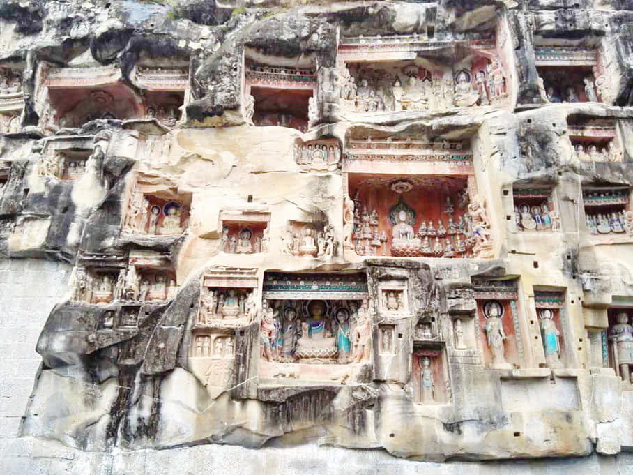
This edition treats cliff sculpture, local gazetteers, a historic church photograph, mission records, old-town memory, porter songs, food products, forest landscapes, modern transport, and everyday county life as different evidence types. Public history is presented neutrally: institutional narratives, archival documents, visual observation, community practice, archaeology, and current conservation are labeled rather than collapsed into one certainty.
This city-specific topic connects place, daily life, and the wider municipal landscape: Land and water.
This city-specific topic connects place, daily life, and the wider municipal landscape: Historical layers.
This city-specific topic connects place, daily life, and the wider municipal landscape: Living culture.
This city-specific topic connects place, daily life, and the wider municipal landscape: County diversity.
Thirty-six published, rights-cleared records cover all five county-level units through accurately labeled photographs, archival documents, maps, and ingredient context. The wall distinguishes current visual evidence, dated city records, institutional source naming, generic food context, and unresolved field questions instead of manufacturing imagery for missing places. A further dated plaza record remains in the rights archive but is intentionally excluded from the public wall.
This city-specific topic connects place, daily life, and the wider municipal landscape: Micang Mountain south slope.[1][2][3][4]
Four geographic relationships define Bazhong.
This city-specific topic connects place, daily life, and the wider municipal landscape: Micang Mountain south slope.[1][2][3][4]
This city-specific topic connects place, daily life, and the wider municipal landscape: Qu River headwater system.[1][2][3][4]
This city-specific topic connects place, daily life, and the wider municipal landscape: Red-sandstone hills.[1][2][3][4]
This city-specific topic connects place, daily life, and the wider municipal landscape: Five county-level units.[1][2][3][4]
Loading current conditions…
Forecast data: Open-MeteoPermanent residents across Bazhong Municipality
Population figures use the administrative area and source date shown below.[5]Rainy humid valleys and cooler northern mountains create strong seasonal vegetation and flood sensitivity.
Climate describes long-term seasonal patterns; live conditions appear separately.[1][2][3][4]Temperatures rise quickly; rain, cloud, and local elevation call for flexible outdoor plans in Bazhong.[1][2][3][4]
Rainy humid valleys and cooler northern mountains create strong seasonal vegetation and flood sensitivity.[1][2][3][4]
Clearer intervals and cooler evenings usually favor river, old-town, museum, and county routes.[1][2][3][4]
Damp cool conditions make layered clothing and indoor–outdoor route pairing practical.[1][2][3][4]
Ten sourced layers move from archaeological landscape and distributed cliff carving through county institutions, Enyang's route-town history, three gazetteer editions, cross-cultural archives, modern transport, public memory, and contemporary conservation.
Seven perspectives center five different local settings, language, farm and food labor, building and conservation work, porter-song traditions, mobility and care, and shared stewardship without inventing a single Bazhong personality.
Bazhou's urban-river center, Enyang's living town fabric, Tongjiang's cave-and-route landscapes, Nanjiang's northern mountains, and Pingchang's agricultural valleys shape different routines and opportunities. The atlas avoids stereotypes about a single 'Bazhong character.'[5][6][12]
Southwestern Mandarin is widely used, with local vocabulary, rhythm, age, education, migration, media, and county differences. A written bilingual guide cannot reproduce every spoken register and should not turn accent into caricature.[5][6][12]
Rice, oil crops, grain, livestock, edible fungi, pepper, fruit, forestry, processing, transport, markets, cooking, and waste handling depend on seasonal and often under-seen labor. Product stories should name growers and workers, not only brands and dishes.[5][6][12]
Historic carving and construction involved quarrying, design, carving, painting, carpentry, masonry, finance, ritual and maintenance. Today's documentation, scaffolding, drainage, monitoring, security, guiding, cleaning, and repair are skilled work with safety and ethics requirements.[5][6][12]
Bashan porter songs grew from coordinated carrying and movement through difficult terrain. Safeguarding must connect repertoire and performance to labor history, bodily risk, route ecology, named practitioners, consent, teaching, livelihood, and the difference between work context and staged presentation.[5][6][12]
Migration for work or study, return, aging, childcare, disability, schooling, health care, retail, delivery, emergency response, and digital access reshape households. Conditions differ among central neighborhoods, county seats, towns, and remote villages and should be reported without deficit stereotypes.[5][6][12]
Stone sites, old towns, forests, caves, rivers, farms, and roads are working environments as well as destinations. Residents' privacy and access, worker conditions, religious or community use, wildlife rules, waste, water, crowd capacity, rescue, and fair benefit-sharing all matter.[5][6][12]
Thirteen entries place Tongjiang silver ear, Nanjiang yellow goat, Pingchang green pepper, cured pork, Enyang banquets, fungi, grains, preserves, fish, and the whole food system within biology, labor, technique, safety, traceability, animal welfare, affordability, and maker variation.
Three routes pair the core city with contrasting county-level landscapes.
Geology made carving possible, while roads, patronage, workshops, Buddhist practice, weathering, repainting, and conservation shaped what survives.
Read the story