
Published and indexedVersion 1.1.0

Ziyang 资阳

Sichuan Province · Sichuan Province, Southwest China

A compact central Sichuan city where Anyue's dispersed stone carvings, Jiuqu River neighborhoods, Lezhi county culture, transport links, lemon farming, and rural heritage require exploration beyond the urban core.
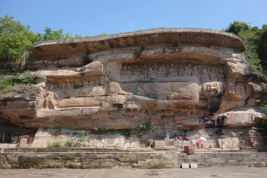
Reclining figure and carved cliff at Wofoyuan
Photo: Nekitarc · source · CC BY-SA 4.0

At a glance

Region
Sichuan Province[1][2][3][4]
Administrative type
1 district and 2 counties[1][2][3][4]
Time zone
China Standard Time (UTC+8)[1][2][3][4]
Population
2.218 million(End of 2024)[1][2][3][4]
Climate
Humid subtropical monsoon climate[1][2][3][4]
Guide scope
Complete municipal coverage across 1 district and 2 counties[1][2][3][4]

Understand Ziyang through connected city and county landscapes

Ziyang is best understood as three connected but different settings: Yanjiang's Tuo River urban core, Anyue's dispersed cliff-sculpture and agricultural landscape, and Lezhi's county-town, performance, farming, and public-memory institutions. The 2024 bulletin counted 2.218 million permanent residents across the municipality; that dated statistical scope is separate from live population estimates or visitor counts.

Anyue's heritage is a network, not one monument. The provincial heritage authority reported 506 grotto and stone-carving points in its 2024 cooperation update, while other institutional pages use different aggregation levels. Counts must retain source, date, definition, and whether they refer to sites, protected units, points, niches, or individual figures.

The visual record connects monuments with towns, bridges, rivers, reservoirs, fields, services, food labor, and conservation. It distinguishes original carving from replica, digital model from physical surface, institutional interpretation from archaeological evidence, and attractive imagery from current access or safety.

Ziyang has a humid subtropical monsoon climate with hot humid summers, mild cloudy winters, and basin-hill variation. This is long-term climate context, not live weather. Travel decisions still require current forecasts, heat, rain, flood, fog, road, and site notices; rural grotto access can differ sharply by season and conservation work.

Land and water

This city-specific topic connects place, daily life, and the wider municipal landscape: Land and water.

Historical layers

This city-specific topic connects place, daily life, and the wider municipal landscape: Historical layers.

Living culture

This city-specific topic connects place, daily life, and the wider municipal landscape: Living culture.

County diversity

This city-specific topic connects place, daily life, and the wider municipal landscape: County diversity.

Location, boundary, and 3D buildings

This city-specific topic connects place, daily life, and the wider municipal landscape: Central basin hills.[1][2][3][4]

Loading city geometry…
County boundaries: © OpenStreetMap contributors · ODbL

Geography and the shape of the city

Four geographic relationships define Ziyang.

Central basin hills

This city-specific topic connects place, daily life, and the wider municipal landscape: Central basin hills.[1][2][3][4]

Tuo River tributaries

This city-specific topic connects place, daily life, and the wider municipal landscape: Tuo River tributaries.[1][2][3][4]

Chengdu–Chongqing corridor

This city-specific topic connects place, daily life, and the wider municipal landscape: Chengdu–Chongqing corridor.[1][2][3][4]

Three county-level units

This city-specific topic connects place, daily life, and the wider municipal landscape: Three county-level units.[1][2][3][4]

Weather now

Loading current conditions…

Forecast data: Open-Meteo

Population

2.218 million

Permanent residents across Ziyang Municipality

Population figures use the administrative area and source date shown below.[5]

Climate

Humid subtropical monsoon climate

Hot humid summers, mild cloudy winters, and rolling basin hills support dense agriculture around tributary valleys.

Climate describes long-term seasonal patterns; live conditions appear separately.[1][2][3][4]

Seasonal patterns

March–May

Spring

Temperatures rise quickly; rain, cloud, and local elevation call for flexible outdoor plans in Ziyang.[1][2][3][4]

June–August

Summer

Hot humid summers, mild cloudy winters, and rolling basin hills support dense agriculture around tributary valleys.[1][2][3][4]

September–November

Autumn

Clearer intervals and cooler evenings usually favor river, old-town, museum, and county routes.[1][2][3][4]

December–February

Winter

Damp cool conditions make layered clothing and indoor–outdoor route pairing practical.[1][2][3][4]

A short history of the city

Ten sourced layers move from archaeology and early-date claims through Tang–Song networks, cliff scripture, county institutions, modern transport, neutral public memory, inventory definitions, digital replicas, and continuous conservation.

Image credits and licenses
  1. River terraces, low hills, soils, water, farming, settlement traces, graves, artifacts, excavation areas, unexcavated deposits, collections, dating, and modern construction form the earliest evidence. The Mengxi River record should be interpreted through published archaeology rather than destination folklore.

    Archaeology and evidence limits[6][12]

  2. Institutional local-history sources connect Anyue carving with early medieval dates, including a 521 reference. Such precise claims need inscription, text, excavation, stylistic comparison, and publication context; a date repeated on a tourism page is not self-validating.

    Source criticism[10]

  3. Large and small niches, patrons, workshops, routes, villages, temples, scripture, ritual, local stone, tools, labor, pigments, repair, reuse, and regional exchange created a distributed landscape. Similar style does not prove one workshop, one date, or uninterrupted use.

    Network rather than monument[7][10]

  4. Wofoyuan combines carved image, text, cliff geology, viewing distance, route, water, light, and weathering. Reading, transcription, translation, textual lineage, missing passages, later recutting, and material condition should be kept distinct.

    Text and material surface[10][9]

  5. County seats, markets, ferries, roads, bridges, temples, schools, craft, agriculture, tax and administrative systems linked rural heritage to everyday life. The historical record differs among Yanjiang, Anyue, and Lezhi and should not be collapsed into one municipal timeline.

    Three local trajectories[6]

  6. Rail, roads, bridges, motorization, housing, industry, county services, migration, schooling, health care, water and drainage changed access and settlement. Dated photos help compare form, but business names, building use, traffic, and river conditions need current evidence.

    Dated urban records[6][5]

  7. Museums, former-residence sites, monuments, exhibitions, collections, labels, architecture, ceremonies, visitors, and education construct public history. This atlas documents them neutrally, separates institution narrative from primary evidence, and takes no political position.

    Neutral institutional reading[6][12]

  8. A protected unit may contain multiple points, and one point may contain many niches and figures. National, provincial, municipal, and county designations, inventory dates, protection boundaries, ownership, access, and condition are not interchangeable counts.

    Definitions before numbers[7][5]

  9. Photography, photogrammetry, laser or structured-light capture, models, VR/AR, 3D printing, databases, displays, metadata, color management, versioning, storage, access, and rights can support study and interpretation. A replica or screen must always be labeled separately from the original carved surface.

    Digital is not original[8]

  10. Monitoring, runoff control, drainage, vegetation, salts, biological growth, cracks, pigment, supports, shelters, visitor routes, lighting, fire, security, documentation, emergency planning, research, training, funding, and community communication require site-specific decisions. Online beauty is not evidence of stability.

    Care is continuous[9][7]

People, language, and everyday rhythms

Seven perspectives center three different local settings, language, heritage and conservation labor, agriculture and food work, performance transmission, unequal mobility and care, and shared visitor responsibility without inventing a single Ziyang personality.

Three local settings, not one personality

Yanjiang, Anyue, and Lezhi contain neighborhoods, villages, county towns, age groups, occupations, languages, incomes, abilities, beliefs, and life histories. The atlas avoids personality ratings, stereotypes, or claims that all residents share one lifestyle.[5][6][11][14]

Language and communication

Mandarin, Sichuan speech varieties, professional terminology, school language, family usage, signing, captions, translation, literacy, hearing, vision, migration, and generational change shape communication. Record real speakers with consent rather than imitating an accent.[5][6][11][14]

Carvers, conservators, and researchers

Traditional carving, building, stone work, documentation, archaeology, chemistry, engineering, photography, digital modeling, interpretation, security, cleaning, and administration are different kinds of labor. Credit practitioners and disclose whether work is original creation, repair, replica, or research.[5][6][11][14]

Agriculture and food labor

Lemon orchards, grain, vegetables, fruit, livestock, markets, processors, transport, kitchens, restaurants, canteens, delivery, inspection, cleaning, care, and waste work connect farms to meals. Product branding should not erase wages, risk, gendered labor, or batch-level traceability.[5][6][11][14]

Performance and transmission

Sichuan opera in Lezhi involves teachers, young performers, musicians, costume and makeup workers, venues, families, audiences, rehearsal, repertoire, funding, consent, safety, and changing careers. One institutional event cannot represent all local performance culture.[5][6][11][14]

Mobility, care, and unequal access

Commuting, migration, buses, rail, private vehicles, walking, disability access, schooling, hospitals, elder and child care, digital access, heat, rain, rural roads, cost, time, and service concentration shape opportunity differently across the municipality.[5][6][11][14]

Stewardship and visitor responsibility

Residents, landholders, faith communities, guides, site staff, researchers, vendors, drivers, officials, educators, visitors, and online publishers all influence heritage. Do not touch, trace, rub, climb, flash, geotag restricted points, trespass, obstruct worship, or circulate unsafe access advice.[5][6][11][14]

Culture and daily life

Image credits and licenses

Anyue's distributed grotto culture

Cliffs, villages, paths, temples, patrons, workshops, ritual, scripture, local materials, agriculture, weather, repair, conservation, and contemporary interpretation form a network. A famous statue is an entry point, not the whole culture.[7][10][11][8][14]

Iconography with evidence boundaries

Names, gestures, crowns, attributes, attendant groups, narrative scenes, scripture, inscriptions, style, color, and spatial sequence require catalogues and specialist comparison. Captions retain source naming and disclose uncertainty.[7][10][11][8][14]

Color, pigment, and repainting

Visible red, blue, green, white, black, and gilded-looking surfaces may include original layers, later repainting, deposits, repair, lighting, camera processing, and loss. Photographs cannot establish pigment chronology.[7][10][11][8][14]

Stone-carving craft

The national ICH record concerns living knowledge and contemporary practice, not automatic authorship of ancient monuments. Tools, design, apprenticeship, stone, dust, safety, commissions, repair ethics, markets, credit, and transmission deserve separate documentation.[7][10][11][8][14]

Cliff scripture and reading practice

Text on stone connects calligraphy, carving, scripture, language, route, ritual, preservation, transcription, translation, loss, and accessibility. No photograph or modern translation should be treated as a complete edition.[7][10][11][8][14]

Sichuan opera in Lezhi

Teaching, voice, gesture, percussion, strings, costume, makeup, repertoire, rehearsal, stage, community venue, youth participation, funding, consent, and career pathways make performance culture visible beyond a promotional show.[7][10][11][8][14]

County markets and everyday social life

Markets connect food, tools, clothing, services, transport, credit, informal knowledge, household schedules, prices, hygiene, weather, waste, accessibility, and changing retail. They should be documented with consent and without treating people as scenery.[7][10][11][8][14]

River and bridge culture

Tuo River and tributary life includes water supply, flood memory, crossing, fishing rules, embankments, recreation, transport, drainage, rescue, pollution control, ecology, and everyday movement. One scenic view cannot summarize water culture.[7][10][11][8][14]

Public-memory institutions

Buildings, collections, labels, exhibitions, guides, ceremonies, school visits, archives, funding, renovation, omission, and debate shape institutional memory. The atlas describes these practices neutrally without political endorsement.[7][10][11][8][14]

Digital interpretation and replicas

Models, screens, VR/AR, 3D prints, interactive maps, captions, sound, access features, metadata, versioning, color, device limits, and preservation can widen access when replica, reconstruction, hypothesis, and original are clearly labeled.[7][10][11][8][14]

Conservation as cultural practice

Inspection, cleaning, monitoring, drainage, vegetation control, scientific analysis, craft knowledge, documentation, procurement, training, visitor management, community communication, and restraint are cultural work, not merely technical maintenance.[7][10][11][8][14]

Ethical photography and publishing

Permission, flash rules, tripods, crowds, privacy, worship, workers, children, restricted locations, color editing, captions, accessibility, creator credit, license, geodata, and takedown requests should be built into the visual record.[7][10][11][8][14]

Food and local flavor

Thirteen entries put Anyue lemons, mutton soup, Lezhi roast meat, Danshan liangfen, fermented bean paste, vegetables, fungi, livestock, fish, preserves, daily meals, and the whole food system within origin, technique, labor, safety, traceability, affordability, environment, and maker variation.

Image credits and licenses
A named agricultural product whose story includes cultivar, orchard, soil, water, weather, pruning, flowers and pollination, pest management, harvest, grading, residues, storage, processing, labels, certification, traceability, price, labor, and export. Institutional scale claims are dated and need independent checking.

Anyue lemons

From orchard to batch[13][5]

Color, peel, shape, juice, seeds, aroma, acidity, damage, wax, storage, cultivar, origin, grade, residues, and freshness cannot be fully judged from a generic photograph. The wall explicitly labels the image as non-Anyue context.

Fresh lemon and visual limits

Generic image, precise label[13]

Juice, slices, preserves, peel, oil, seasoning, bakery use, drinks, concentrates, drying, sugar, additives, allergens, sanitation, packaging, shelf life, refrigeration, claims, and waste streams vary by maker. A place name does not validate a product batch.

Lemon processing and drinks

Processing variation[13]

Local descriptions should document animal source, cut, bones, broth, blanching, simmering, fat, aromatics, garnish, serving temperature, kitchen hygiene, cold chain, price, portion, salt, allergies, and maker variation. The generic image is explicitly a Beijing serving, not Ziyang proof.

Ziyang mutton soup

Recipe requires local evidence[5][12]

The dated 2025 institutional update includes Lezhi roast meat among standardized local dishes, but one standard cannot erase household and restaurant variation. Fuel, cut, marination, skewers or roasting surface, heat, doneness, smoke, fire safety, raw-cooked separation, price, and labor matter.

Lezhi roast meat

Standard and variation[12]

The institutional update lists Danshan liangfen among intangible food techniques. Starch source, soaking, grinding or flour use, heating, setting, cutting, sauce, chili, sesame or nuts, allergens, water, sanitation, temperature, and maker variation need local documentation; the generic pea-liangfen image is not a local serving.

Danshan liangfen

Technique, not visual imitation[12]

Named fermented products require producer, bean and chili source, salt, water, vessels, microbial process, time, temperature, contamination control, maturation, packaging, labels, geographical claims, sodium, allergens, storage, and batch traceability. Similar-looking paste is not interchangeable.

Linjiang Temple fermented bean paste context

Fermentation and provenance[6]

The 2024 bulletin records large municipal vegetable-and-fungi output under statistical definitions, not a menu. Species, cultivation, season, water, inputs, workers, markets, cold chain, price, residue control, cooking, allergies, and safe identification remain product-specific; never forage from an image.

Seasonal vegetables and fungi

Statistics are not a plate[5]

The bulletin's dated livestock counts describe production scale, not welfare, safety, taste, or sustainability. Breeding, housing, feed, veterinary care, antibiotics, animal welfare, slaughter, inspection, cold chain, workers, waste, water, emissions, price, and household access require separate evidence.

Pork, poultry, and sheep systems

Scale with responsibility[5]

Fish dishes depend on verified species, legal capture or aquaculture, water quality, feed, medicines, cold chain, bones, parasites, thorough cooking, seasoning, price, and maker technique. River photographs do not certify edible catch or sustainable harvest.

River and pond fish

Source before flavor[5]

Salt, brine, vessels, temperature, time, cleanliness, vegetables, spices, reuse, refrigeration, mold distinction, cross-contamination, sodium, and household taste vary. Tradition never replaces food-safety controls.

Pickles and household preserves

Preservation with safety[5]

Rice, noodles, corn, roots, beans, tofu, eggs, greens, fruit, meat, soup, canteens, school and hospital meals, home cooking, restaurants, takeaway, season, price, nutrition, allergies, medical needs, religion, age, time, and household labor describe ordinary eating more accurately than a famous-food list.

Daily meals beyond destination brands

Everyday food diversity[5]

Orchards, fields, livestock, water, seed and breed decisions, farm inputs, weather, workers, processors, warehouses, cold chain, roads, markets, shops, kitchens, inspection, affordability, nutrition, packaging, wastewater, smoke, compost, leftovers, and refuse collection together make Ziyang food.

The complete food system

From landscape to leftovers[5]

Landmarks and architecture

Image credits and licenses

Pilu Cave

A major Anyue site whose figures, niche architecture, pigment, stone, shelter, route, lighting, visitor scale, repairs, monitoring, access, and interpretation should be read together. Famous imagery does not remove the need for site rules and conservation restraint.[6][7][9][10][12]

Wofoyuan

A cliff complex joining reclining sculpture, carved scripture, sandstone, topography, water, light, text, route, protection, and restricted surfaces. Reading and condition require specialist documentation; never touch or trace inscriptions.[6][7][9][10][12]

Yuanjue Cave

A monumental cliff group of principal figures, attendants, flying figures, relief architecture, pigment, shelters, paths, and modern management. Each image covers a portion; plan, numbering, inscriptions, dates, and condition need the site catalogue.[6][7][9][10][12]

Thousand-Buddha Camp

A dense site of many niches across vegetated sandstone. Counts, chronology, iconography, routes, cliff stability, runoff, vegetation, biological growth, visitor paths, barriers, lighting, and current access require inventory and operator evidence.[6][7][9][10][12]

Huayan Cave

A densely carved interior where iconography, figure relationships, pigment, stone, shadow, moisture, salts, surface deposits, supports, lighting, photography, visitor capacity, and conservation interventions need careful separation.[6][7][9][10][12]

Peacock Cave

A smaller rural point valuable for understanding distributed heritage. Approach roads, paths, land use, ownership, worship, vegetation, runoff, stone condition, opening, emergency access, and community relationships may differ from major managed sites.[6][7][9][10][12]

Mingshan Temple carvings

Monumental and cliff-fitted figures at Mingshan require measured survey, source-based naming, iconographic comparison, pigment and stone analysis, repair history, vegetation control, access information, and respectful visitor behavior.[6][7][9][10][12]

Xuanmiao Temple carvings

Open-air carvings make weather, drainage, plant growth, surface loss, shelter questions, route, neighboring land use, and site-specific vulnerability visible. Do not generalize their condition to the whole Anyue network.[6][7][9][10][12]

Tongxian Sanfo Cave

A smaller heritage point that broadens the route beyond headline monuments. Identity, date, iconography, protection level, ownership, road, opening, structural condition, and documentation should be checked before visiting.[6][7][9][10][12]

Kunfo Temple cliff carvings

Lezhi's carved cliff record shows that municipal heritage extends beyond Anyue. Dating, iconography, material, exposure, local use, protection status, route, access, and conservation need monument-specific evidence.[6][7][9][10][12]

Tuo River and Yanjiang urban core

River channels, tributaries, bridges, embankments, drainage, flood control, water supply, rescue, ecology, housing, roads, transit, commerce, public space, lighting, utilities, and hill terrain form a changing urban system—not one postcard view.[6][7][9][10][12]

Mengxi River landscape

River hydrology, banks, agriculture, settlement, bridges, drainage, water quality, ecology, flood and drought, archaeology, extraction, recreation, and governance overlap. Exact archaeological locations may appropriately remain restricted.[6][7][9][10][12]

Paomatan Reservoir

A working water landscape involving operator, purpose, levels, catchment, dams and spillways, irrigation or supply, fisheries, ecology, water quality, drought, flood control, public safety, roads, settlements, and changing access.[6][7][9][10][12]

Lezhi bridges and county town

Bridges, drainage corridors, roads, walking, vehicles, housing, shops, utilities, lighting, accessibility, maintenance, flood exposure, public space, and later reconstruction shape everyday mobility. Dated photos are records, not current safety evidence.[6][7][9][10][12]

Public-memory institutions in Lezhi

Architecture, collections, exhibitions, labels, archives, guides, education, ceremonies, renovations, visitors, omissions, and institutional narratives form a cultural site. The atlas documents these layers neutrally and does not take a political position.[6][7][9][10][12]

Three-unit county map

Yanjiang District, Anyue County, and Lezhi County are the minimum geographic frame for this edition. Boundary source, date, license, names, click behavior, zoom, map accessibility, and links to local content must remain transparent and maintainable.[6][7][9][10][12]

Ways to explore the city

Three routes pair the core city with contrasting county-level landscapes.
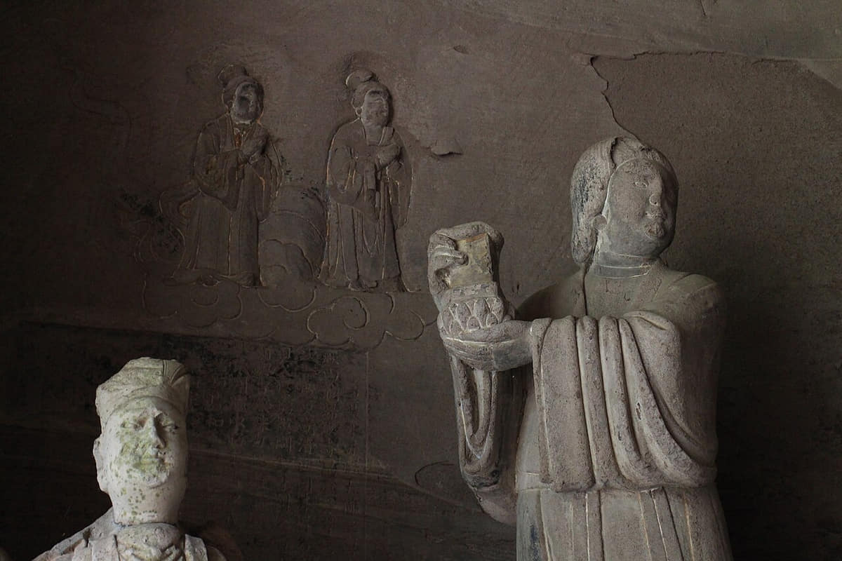
Field route

Ziyang Museum → Jiuqu River → old neighborhoods

Use this sequence to compare the core city with a distinct county-level landscape.[1][2][3][4]

Field route

Pilu Cave → Huayan Cave → Anyue county town

Use this sequence to compare the core city with a distinct county-level landscape.[1][2][3][4]

Field route

Wofoyuan → rural carving sites → Lezhi market

Use this sequence to compare the core city with a distinct county-level landscape.[1][2][3][4]

Continue with a local story

Documentary image for a local story about Ziyang
Photo: Xin · source · CC BY-SA 4.0
Featured story

Why are Anyue's carvings spread across the countryside?

Cliffs, roads, villages, patrons, workshops, worship, farming, weather, and modern access created a network rather than one enclosed monument.

Read the story

Sources, revision, and publication status

v1.1.0
Last content update
Publication statusPublished
Image verificationImage rights and place accuracy are approved.
Map verificationMap license, version, and administrative code are verified.

Numbered reference sources

  1. Ziyang Municipal Government — official portal
  2. Ziyang — reviewed population and statistical reference
  3. Sichuan Local Chronicles — Ziyang records
  4. China Meteorological Administration — climate reference
  5. 2024 Ziyang statistical bulletin — population, agriculture, culture, museums, heritage, environment, and dated definitions
  6. Sichuan Government — Ziyang geography, administration, river setting, cultural heritage, and city profile
  7. Sichuan heritage authority — Ziyang–Dazu grotto inventory, conservation cooperation, research, and route context
  8. Sichuan heritage authority — digital recording, modeling, VR/AR, 3D printing, and museum interpretation at Anyue
  9. Sichuan heritage authority — monitoring, site-specific stone conservation, safety, and pilot projects in Anyue
  10. Sichuan Local Chronicles — Anyue carving history, cliff scripture, sites, and written local context
  11. National ICH record — Anyue stone-carving craft, project identity, transmission, and contemporary practice
  12. Sichuan Government — dated 2025 museum, archaeology, route, food-standard, and intangible-food update
  13. Sichuan institutional update — dated Anyue lemon cultivation, processing, and export claims
  14. Sichuan culture authority — Lezhi Sichuan-opera teaching, youth performance, and safeguarding context
Report a correction