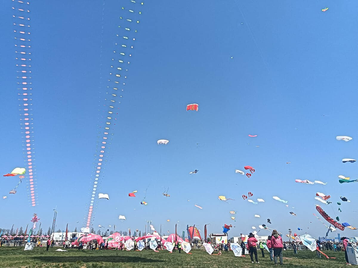
Weifang is a large plain–coast municipality in Shandong, China. Its twelve county-level units connect kite and Yangjiabu print traditions with Qingzhou archaeology and gardens, Shouguang agriculture, Bohai wetlands, industrial towns and southern hill counties.
9.387 million · 2020 census, 1 November 2020[1][2][3][4]
Climate
Warm-temperate, semi-humid continental monsoon climate with coastal influence[1][2][3][4]
Map scope
12 county-level units with reviewed boundaries[1][2][3][4]
Weifang, China city guide: kites, Qingzhou and twelve local units
Weifang is a large plain–coast municipality of kites, Yangjiabu prints, Qingzhou archaeology and gardens, Gaomi paper craft, Shouguang greenhouse agriculture, Bohai wetlands, industrial towns, and southern hill counties.
Bohai coast and Laizhou Bay, Central Shandong plain, Mi and Zi river basins, Southern Yimeng foothills explain why the municipality cannot be reduced to its best-known landmark.
Weifang kite making and flying, Yangjiabu woodblock New Year prints, Qingzhou archaeology and museum work, Gaomi paper cutting, Gaomi clay tiger making, Shouguang greenhouse knowledge are documented as distinct practices carried by particular institutions and communities, not as traits shared by every resident.
This profile separates dated population, long-term climate, live weather, historical evidence, current access, and editorial interpretation. District and county conditions require local checks.
Land and water
Land and water, Historical layers, and Living culture and work form a connected spatial system in Weifang. Reading them together keeps the central city, outer districts, county seats, villages, water, and terrain at their proper scales.
Historical layers
Historical layers, Living culture and work, and County-level differences form a connected spatial system in Weifang. Reading them together keeps the central city, outer districts, county seats, villages, water, and terrain at their proper scales.
Living culture and work
Living culture and work, County-level differences, and Land and water form a connected spatial system in Weifang. Reading them together keeps the central city, outer districts, county seats, villages, water, and terrain at their proper scales.
County-level differences
County-level differences, Land and water, and Historical layers form a connected spatial system in Weifang. Reading them together keeps the central city, outer districts, county seats, villages, water, and terrain at their proper scales.
Bohai coast and Laizhou Bay, Central Shandong plain, and Mi and Zi river basins form a connected spatial system in Weifang. Reading them together keeps the central city, outer districts, county seats, villages, water, and terrain at their proper scales.[1][2][3][4]
Central Shandong plain
Central Shandong plain, Mi and Zi river basins, and Southern Yimeng foothills form a connected spatial system in Weifang. Reading them together keeps the central city, outer districts, county seats, villages, water, and terrain at their proper scales.[1][2][3][4]
Mi and Zi river basins
Mi and Zi river basins, Southern Yimeng foothills, and Bohai coast and Laizhou Bay form a connected spatial system in Weifang. Reading them together keeps the central city, outer districts, county seats, villages, water, and terrain at their proper scales.[1][2][3][4]
Southern Yimeng foothills
Southern Yimeng foothills, Bohai coast and Laizhou Bay, and Central Shandong plain form a connected spatial system in Weifang. Reading them together keeps the central city, outer districts, county seats, villages, water, and terrain at their proper scales.[1][2][3][4]
Population figures use the administrative area and source date shown below.[1][2][3][4]
Climate
Warm-temperate, semi-humid continental monsoon climate with coastal influence
The Bohai coast is windier and more saline, the central plain hot in summer, and the southern hills cooler and wetter; typhoons, drought, floods, and spring wind vary by county.
Climate describes long-term seasonal patterns; live conditions appear separately.[1][2][3][4]
Seasonal patterns
March–May
Spring
Spring conditions in Weifang can change quickly. Check rain, wind, fog, pollen, temperature, elevation, and coastal or mountain exposure for the exact route.[1][2][3][4]
June–August
Summer
The Bohai coast is windier and more saline, the central plain hot in summer, and the southern hills cooler and wetter; typhoons, drought, floods, and spring wind vary by county.[1][2][3][4]
September–November
Autumn
Autumn often brings cooler evenings and clearer intervals, but river, coast, mountain, desert, grassland, and county conditions still require a current forecast.[1][2][3][4]
December–February
Winter
Winter varies across Weifang's municipality. Check cold, wind, ice, snow, fog, heating, road, and elevation conditions rather than applying one city-center forecast everywhere.[1][2][3][4]
A short history of the city
Five dated layers connect material evidence with present urban and county form.
Settlements across plain and coast
Settlements across plain and coast belongs to Weifang's longer sequence from Settlements across plain and coast to Kite culture, greenhouse systems, and coastal stewardship. Archaeology, surviving sites, collections, routes, maps, and current urban form provide different evidence and should not be collapsed into one narrative.[1][2][3][4]
Qingzhou administration, gardens, and temples
Qingzhou administration, gardens, and temples belongs to Weifang's longer sequence from Settlements across plain and coast to Kite culture, greenhouse systems, and coastal stewardship. Archaeology, surviving sites, collections, routes, maps, and current urban form provide different evidence and should not be collapsed into one narrative.[1][2][3][4]
Print villages, markets, and craft networks
Print villages, markets, and craft networks belongs to Weifang's longer sequence from Settlements across plain and coast to Kite culture, greenhouse systems, and coastal stewardship. Archaeology, surviving sites, collections, routes, maps, and current urban form provide different evidence and should not be collapsed into one narrative.[1][2][3][4]
Rail, industry, agriculture, and urbanization
Rail, industry, agriculture, and urbanization belongs to Weifang's longer sequence from Settlements across plain and coast to Kite culture, greenhouse systems, and coastal stewardship. Archaeology, surviving sites, collections, routes, maps, and current urban form provide different evidence and should not be collapsed into one narrative.[1][2][3][4]
Kite culture, greenhouse systems, and coastal stewardship
Kite culture, greenhouse systems, and coastal stewardship belongs to Weifang's longer sequence from Settlements across plain and coast to Kite culture, greenhouse systems, and coastal stewardship. Archaeology, surviving sites, collections, routes, maps, and current urban form provide different evidence and should not be collapsed into one narrative.[1][2][3][4]
People, language, and everyday rhythms
Residents are described through language, work, mobility, neighborhood, and present choice—not fixed personality labels.
Weifang local speech and Standard Mandarin
Language use varies by household, generation, neighborhood, school, workplace, county, and migration history. Speech cannot be used as a fixed identity label.[1][2][3][4]
Urban cores, county seats, towns, and villages
Weifang's communities differ in density, services, transport, work, land use, and daily schedules across the municipality.[1][2][3][4]
Work, study, migration, and family networks
Residents connect Weifang to other places through employment, study, trade, care, migration, and tourism, continually changing local communities.[1][2][3][4]
Community-specific and changing identities
Age, occupation, language, gender, neighborhood, county background, and personal choice produce varied experiences; no single personality represents Weifang.[1][2][3][4]
Culture and daily life
Weifang kite making and flying
Weifang kite making and flying is presented through named places, practitioners, institutions, materials, work, and community choices. Its relationship with Yangjiabu woodblock New Year prints and Qingzhou archaeology and museum work shows a living, changing practice rather than a fixed citywide identity.[1][2][3][4]
Yangjiabu woodblock New Year prints
Yangjiabu woodblock New Year prints is presented through named places, practitioners, institutions, materials, work, and community choices. Its relationship with Qingzhou archaeology and museum work and Gaomi paper cutting shows a living, changing practice rather than a fixed citywide identity.[1][2][3][4]
Qingzhou archaeology and museum work
Qingzhou archaeology and museum work is presented through named places, practitioners, institutions, materials, work, and community choices. Its relationship with Gaomi paper cutting and Gaomi clay tiger making shows a living, changing practice rather than a fixed citywide identity.[1][2][3][4]
Gaomi paper cutting
Gaomi paper cutting is presented through named places, practitioners, institutions, materials, work, and community choices. Its relationship with Gaomi clay tiger making and Shouguang greenhouse knowledge shows a living, changing practice rather than a fixed citywide identity.[1][2][3][4]
Gaomi clay tiger making
Gaomi clay tiger making is presented through named places, practitioners, institutions, materials, work, and community choices. Its relationship with Shouguang greenhouse knowledge and Weifang kite making and flying shows a living, changing practice rather than a fixed citywide identity.[1][2][3][4]
Shouguang greenhouse knowledge
Shouguang greenhouse knowledge is presented through named places, practitioners, institutions, materials, work, and community choices. Its relationship with Weifang kite making and flying and Yangjiabu woodblock New Year prints shows a living, changing practice rather than a fixed citywide identity.[1][2][3][4]
Food and local flavor
Six locally named food records connect ingredients, technique, work, markets, and social settings.
Chaotian pot is one locally named food record. Ingredients, technique, season, maker, serving context, and district or county provenance should be checked separately rather than inferred from the name alone.
Weifang meat huoshao is one locally named food record. Ingredients, technique, season, maker, serving context, and district or county provenance should be checked separately rather than inferred from the name alone.
Weixian radish is one locally named food record. Ingredients, technique, season, maker, serving context, and district or county provenance should be checked separately rather than inferred from the name alone.
Gaomi stove buns is one locally named food record. Ingredients, technique, season, maker, serving context, and district or county provenance should be checked separately rather than inferred from the name alone.
Qingzhou noodles is one locally named food record. Ingredients, technique, season, maker, serving context, and district or county provenance should be checked separately rather than inferred from the name alone.
Vegetable pancakes is one locally named food record. Ingredients, technique, season, maker, serving context, and district or county provenance should be checked separately rather than inferred from the name alone.
Weifang kite culture is a physical entry point into Weifang. Surviving fabric, date, use, conservation, current access, and its relationship with Shihu Garden remain separate questions.[1][2][3][4]
Shihu Garden
Shihu Garden is a physical entry point into Weifang. Surviving fabric, date, use, conservation, current access, and its relationship with Qingzhou Museum remain separate questions.[1][2][3][4]
Qingzhou Museum
Qingzhou Museum is a physical entry point into Weifang. Surviving fabric, date, use, conservation, current access, and its relationship with Qingzhou Ancient City remain separate questions.[1][2][3][4]
Qingzhou Ancient City
Qingzhou Ancient City is a physical entry point into Weifang. Surviving fabric, date, use, conservation, current access, and its relationship with Shouguang Vegetable Sci-Tech Fair remain separate questions.[1][2][3][4]
Shouguang Vegetable Sci-Tech Fair
Shouguang Vegetable Sci-Tech Fair is a physical entry point into Weifang. Surviving fabric, date, use, conservation, current access, and its relationship with Bailang River remain separate questions.[1][2][3][4]
Bailang River
Bailang River is a physical entry point into Weifang. Surviving fabric, date, use, conservation, current access, and its relationship with Weifang kite culture remain separate questions.[1][2][3][4]
Ways to explore the city
Three field sequences connect the urban core with contrasting district or county landscapes.
Field route
Kite Museum → riverfront → Yangjiabu workshops
Kite Museum → riverfront → Yangjiabu workshops is route 1 for comparing Weifang's built form, landscape, work, and district or county context. Verify live weather, transport, opening, safety, and conservation rules before departure.[1][2][3][4]
Field route
Qingzhou museum → old city → mountain foothills
Qingzhou museum → old city → mountain foothills is route 2 for comparing Weifang's built form, landscape, work, and district or county context. Verify live weather, transport, opening, safety, and conservation rules before departure.[1][2][3][4]
Field route
Shouguang greenhouses → coastal wetland → fishing port
Shouguang greenhouses → coastal wetland → fishing port is route 3 for comparing Weifang's built form, landscape, work, and district or county context. Verify live weather, transport, opening, safety, and conservation rules before departure.[1][2][3][4]
Shandong connections
Continue through Shandong
Place Weifang's kite, print, garden, agricultural and coastal histories beside related city and province guides.