Xinjiang Uygur Autonomous Region · Northwest China
A Tianshan piedmont oasis and inland gateway where mountain water, rail, aviation, logistics, museums, markets, varied languages and communities, food, industry, and county landscapes meet.
Tianshan piedmont oasis, inland transport and logistics, Xinjiang Museum, Red Mountain, multilingual urban life, markets, regional food, industry, and mountain counties[1][2][3][4]
Guide scope
Eight county-level units spanning the dense core, rail and industrial districts, Midong, Dabancheng, Urumqi County mountain valleys, grassland, farms, towns, and desert-edge landscapes[1][2][3][4]
Understand Urumqi through oasis geography, movement, and contemporary plurality
Urumqi sits north of the Tianshan on an oasis supported by mountain water at the edge of a dry basin. Elevation gradients, reservoirs, greenbelts, industry, rail, roads, and water demand structure the metropolis.
The city brings together varied languages, communities, museums, universities, markets, food, logistics, public institutions, workers, migrants, and long-distance travelers. Urumqi County, Dabancheng, Midong, mountain valleys, grassland, villages, and desert edges give the guide necessary municipal range.
Urumqi is a large inland basin-edge metropolis at the northern foot of the Tianshan. Dense central districts, industrial and logistics areas, Midong, Dabancheng, Urumqi County valleys, mountain recreation areas and transport corridors occupy very different environments.
The city is a regional meeting point, not a container for all Xinjiang culture. Museum collections, foods, textiles and performances may originate anywhere in the region; captions must state whether evidence concerns Urumqi, a regional tradition or an object displayed in the city.
Tianshan piedmont oasis
Mountain water, alluvial fans, dry basin, greenbelts, settlement, and water demand explain urban geography.
Inland transport gateway
Rail, aviation, roads, logistics, markets, bilingual wayfinding, and migration organize the metropolis.
Multiethnic contemporary city
Languages, work, education, neighborhoods, institutions, food, media, migration, and personal choice produce varied identities.
Municipal environmental range
Eight units extend from dense core and industry to mountain valleys, grasslands, wind corridors, farms, towns, and desert edge.
A visual record of the city
Eighteen locally hosted, rights-cleared images cover the central city, outer municipal areas, institutions, transport, daily space and food context. Captions distinguish city evidence from regional references and live conditions.
The core occupies alluvial fans below the Tianshan; the municipality extends through rail and industrial corridors, Midong, Dabancheng, mountain valleys, grasslands, farms, towns, villages, and desert-edge terrain.[1][2][3][4]
Tianshan mountain water, alluvial fans, a dry basin, strong continental seasons, and eight county-level units define Urumqi.
Tianshan piedmont
The city sits on an alluvial fan north of the Tianshan, where mountain water supports an oasis at the edge of the Junggar Basin.[1][2][3][4]
Dry continental basin
Low rainfall, strong sun, hot summers, cold winters, large temperature ranges, wind, and snow shape daily life and infrastructure.[1][2][3][4]
Water and elevation
Mountain snowmelt, reservoirs, rivers, groundwater, canals, greenbelts, and water demand connect highlands with the metropolis.[1][2][3][4]
Eight units
Seven districts and Urumqi County span the dense core, rail and industrial zones, Midong, Dabancheng, mountain valleys, pastoral areas, villages, and desert-edge landscapes.[1][2][3][4]
Population figures use the administrative area and source date shown below.[1][2][3][4]
Climate
Temperate arid continental climate
Hot dry summers, long cold winters, large day–night and seasonal temperature ranges, limited precipitation, strong sun, wind, snow, and inversion conditions shape the city.
Climate describes long-term seasonal patterns; live conditions appear separately.[1][2][3][4]
Seasonal patterns
March–May
Spring
Rapid warming, wind, dust, snowmelt, and changeable conditions require layers, hydration, and current road or air information.[1][2][3][4]
June–August
Summer
Hot dry days, intense sun, cooler nights, thunderstorms, and mountain-route weather favor shade and water planning.[1][2][3][4]
September–November
Autumn
Clear skies, harvest markets, cool nights, rapid leaf change, and early snow make timing important.[1][2][3][4]
December–February
Winter
Long cold periods, snow, ice, inversions, short daylight, and heating conditions shape transport and outdoor time.[1][2][3][4]
A short history of the city
Regional routes, oasis settlement, garrison and market growth, rail, industry, migration, public institutions, and contemporary logistics form visible layers.
Archaeology, pastoral mobility, farming, trade, and routes through the Tianshan and basin predate the modern city.[1][2][3][4]
Garrison and market town
Administration, military settlement, irrigation, markets, migration, craft, and religious institutions expanded an urban center.[1][2][3][4]
Roads and regional commerce
Transport, trade, public institutions, industry, education, and varied communities increased the city's regional role.[1][2][3][4]
Rail and industrial expansion
Railways, manufacturing, housing, universities, utilities, migration, and new districts rapidly enlarged the metropolis.[1][2][3][4]
Inland transport hub
High-speed rail, aviation, logistics, services, industry, museums, markets, metro, environmental management, and county links reshape the city.[1][2][3][4]
Oasis and mountain corridors
Pastoral movement, oasis settlement and routes around the Tianshan connected the basin with wider Central Asian and Chinese networks.[1][2][3][4]
Administrative and commercial town
Garrison, administration, markets, craft, religious institutions and long-distance trade expanded the urban center over several periods.[1][2][3][4]
Rail, industry and migration
Railways, roads, factories, housing, schools, hospitals and migration produced a much larger regional capital.[1][2][3][4]
Basin-scale metropolis
New districts, metro, high-speed rail, logistics, universities, museums and environmental management connect the dense core with outer municipalities.[1][2][3][4]
People, language, and everyday rhythms
Residents include Uyghur, Han, Kazakh, Hui, Mongol and other communities, old and new urban households, students, workers, traders, county residents, migrants, and travelers.
Languages
Standard Mandarin, Uyghur, Kazakh and other languages appear across homes, schools, markets, transport, media, workplaces, and public signage.[1][2][3][4]
Multiethnic metropolis
Uyghur, Han, Kazakh, Hui, Mongol and other communities have varied histories, occupations, neighborhoods, institutions, and present-day identities.[1][2][3][4]
Mobile gateway
Students, traders, logistics and industrial workers, service staff, public employees, migrants, county residents, and long-distance travelers meet here.[1][2][3][4]
Avoiding stereotypes
Food, bazaars, multilingual signs, and mountain scenery are visible, but identity also changes with generation, work, education, neighborhood, migration, and individual choice.[1][2][3][4]
A multilingual city
Uyghur, Han, Kazakh, Hui, Mongol and other residents bring varied languages, religions, occupations, foods and family histories.[1][2][3][4]
No single regional type
Central commuters, students, traders, industrial workers, service employees, county residents and migrants follow different routines; appearance never identifies identity.[1][2][3][4]
Museums connect archaeology, textiles, writing, art, music, trade routes, communities, research, and conservation across a vast region.[1][2][3][4]
Market cultures
Wholesale trade, neighborhood bazaars, food, textiles, household goods, tourism, performance, logistics, and bargaining occupy different market contexts.[1][2][3][4]
Music and performance
Muqam and other regional traditions, dance, instruments, theater, pop music, festivals, recordings, schools, and staged tourism require specific context.[1][2][3][4]
Rail, aviation, logistics, bilingual wayfinding, hotels, markets, warehouses, migrant neighborhoods, and long journeys shape everyday life.[1][2][3][4]
Contemporary plurality
Universities, media, film, literature, design, sports, restaurants, social platforms, and urban work continually reshape representation.[1][2][3][4]
Markets and regional exchange
The Grand Bazaar and other markets combine local commerce, tourism, food, crafts and region-wide products; vendor and product origins require specific evidence.[1][2][3][4]
Museums and provenance
Xinjiang Museum and Urumqi Museum hold regional and municipal collections. Display in the capital never makes an object Urumqi-made.[1][2][3][4]
Religious and community places
Mosques, temples, churches and community institutions are living places with distinct histories, users and access rules.[1][2][3][4]
Contemporary metropolitan culture
Universities, media, literature, music, sport, design, restaurants and multilingual digital life shape present-day expression.[1][2][3][4]
Pulled noodles, vegetables, meat, tomatoes, onions, peppers, sauces, and restaurant or household variation form a common meal.[1][2][3][4]
Rice dish
Polo
Rice, carrots, onions, meat, oil, raisins or other additions, communal service, and household or regional methods create varied versions.[1][2][3][4]
Street and restaurant food
Kebabs and roast meats
Mutton or other meats, skewers, seasoning, ovens or grills, bread, onions, and late-night service appear in many formats.[1][2][3][4]
Everyday staple
Naan and baked breads
Oven shape, dough, patterning, seeds, household use, markets, travel, and different community traditions create a broad family of breads.[1][2][3][4]
Regional ingredients
Dairy, fruit, and nuts
Yogurt, milk tea, cheeses, melons, grapes, dried fruit, walnuts, almonds, and seasonal markets connect the capital with regional production.[1][2][3][4]
Metropolitan exchange
Plural urban table
Uyghur, Kazakh, Hui, Han and other food traditions, migrant cuisines, halal practice, restaurants, homes, and individual preferences coexist.[1][2][3][4]
Restaurant and household dish
Hand-held mutton
Cut, sourcing, seasoning, halal practice, cooking and serving vary; one restaurant photograph is not a citywide standard.[1][2][3][4]
Specialized preparation
Mianfeizi and rice intestines
Wheat, offal, rice, spices, cleaning and cooking require skilled practice and vary by vendor.[1][2][3][4]
Regional rice dish
Pilaf across the regional table
Rice, carrots, oil, meat and household technique vary across Xinjiang; serving in Urumqi does not establish city origin.[1][2][3][4]
Bread and baked foods
Naan and samsa
Flour, oven, filling, shape and neighbourhood practice vary, with fresh handling and allergens needing vendor information.[1][2][3][4]
Commercial and household beverages
Kvass and other drinks
Producer, fermentation, sweetness, alcohol content, refrigeration and season vary.[1][2][3][4]
City market, wider origin
Melons and regional produce
Fruit reaches Urumqi from farms across Xinjiang. Labels and vendors—not the city of sale—determine exact agricultural origin.[1][2][3][4]
A starting point for archaeology, textiles, documents, art, trade routes, communities, research, conservation, and regional chronology.[1][2][3][4]
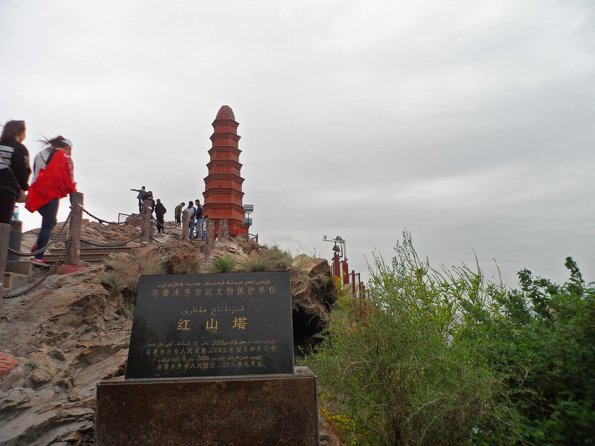
Red Mountain
A central hill and park linking geology, city views, pagoda memory, recreation, vegetation, air conditions, and metropolitan growth.[1][2][3][4]
International Grand Bazaar
A busy commercial and tourism district where architecture, food, performance, trade, residents, transport, and curated image overlap.[1][2][3][4]
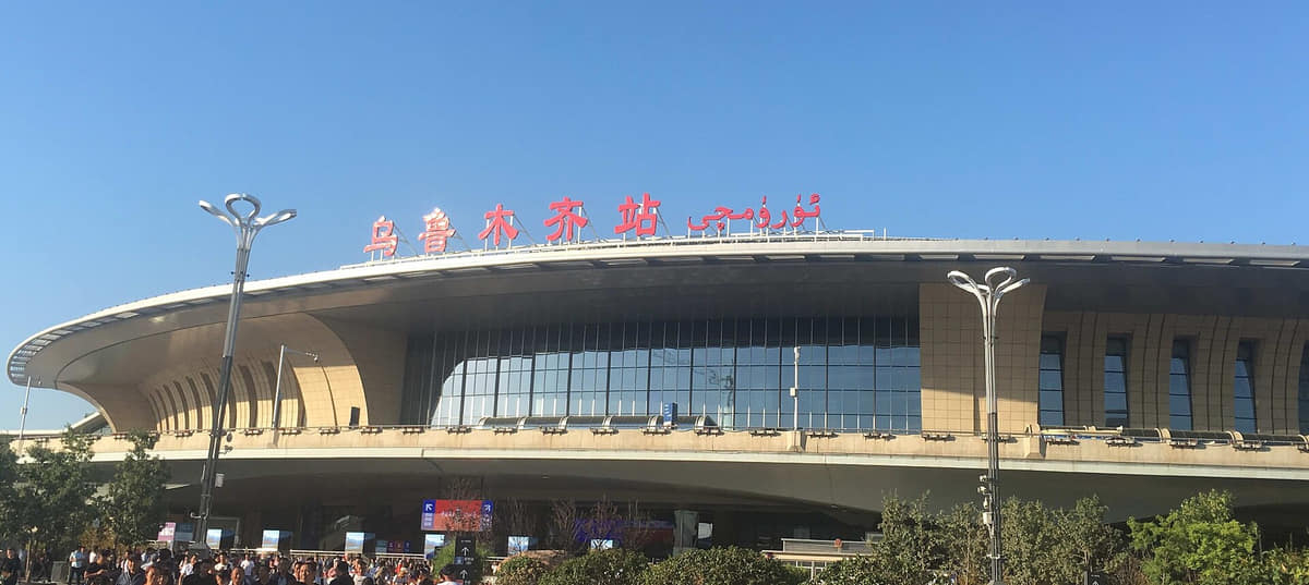
Urumqi Railway Station
A contemporary gateway making rail, logistics, bilingual signage, migration, commuting, new districts, and long-distance movement visible.[1][2][3][4]
Tianshan-facing valleys
Mountain water, forests, grassland, villages, pastoral use, recreation, weather, road conditions, and conservation shape the southern municipality.[1][2][3][4]
Dabancheng and Midong
Wind corridor, transport, energy, industry, agriculture, desert edge, towns, and villages show municipal landscapes beyond the core.[1][2][3][4]
People's Square
A civic space whose landscaping, public uses, events, access and surrounding buildings change over time.[1][2][3][4]
Shuimogou
A district landscape linking water, parks, neighbourhoods, institutions and hillside terrain beyond the central skyline.[1][2][3][4]
Hongshan overlook
A topographic viewpoint that reveals basin-edge growth while air clarity, weather and current construction remain live.[1][2][3][4]
Urumqi Railway Station operations
A major rail gateway; schedules, ticketing, security, station access and transfers require operator information.[1][2][3][4]
Urumqi Museum
A municipal interpretation institution distinct from the region-wide Xinjiang Museum; exhibits retain object-level provenance.[1][2][3][4]
Outer-county landscapes
Urumqi County and Dabancheng extend the municipality into valleys, grasslands, mountain routes, wind corridors and settlements.[1][2][3][4]
Ways to explore the city
Pair museum context with a city overlook, compare daily and visitor markets, then follow one municipal route from the core toward mountain or desert-edge landscapes.
City and region
Xinjiang Museum → Red Mountain
Move from documented regional time depth to a view of the contemporary piedmont metropolis and its environmental setting.[1][2][3][4]
Markets in context
Neighborhood market → Grand Bazaar → food street
Compare daily provisioning, tourism, wholesale links, architecture, performance, transport, and specific food practices.[1][2][3][4]
Municipal gradient
Core → Urumqi County valley, Dabancheng, or Midong
Use current weather and road advice to compare dense city, mountain water, grassland, villages, industry, wind corridors, and desert edge.[1][2][3][4]