Shenyang, China, is the capital of Liaoning Province and a major Northeast China city where Mukden Palace, Qing tombs, industrial transformation, the Hun River and 13 county-level units meet.
Mukden Palace, Qing tombs, heavy industry, Tiexi, museums, the Hun River, and northeastern food[1][2][3][4]
Guide scope
The central palace city, 13 county-level units, industrial districts, Hun River corridor, eastern hills, and rural plain[1][2][3][4]
Shenyang, China city guide: Liaoning capital, Qing history and industry
Shenyang is a large northeastern municipality on the Liao River plain, with the Hun River crossing newer urban districts and wooded hills rising toward the east. Its thirteen county-level units include dense central districts, industrial and residential belts, suburban agriculture, county towns and the county-level city of Xinmin.
The city's history cannot be reduced to one dynasty or one factory. Xinle archaeological evidence, a Ming-period walled city, the seventeenth-century palace and tomb landscapes, railway expansion, war and occupation, industrial growth, worker housing and later restructuring are different layers that require different kinds of evidence.
In 2025 Shenyang recorded 9.276 million permanent residents. Manufacturing remains important, while services, universities, research, museums, transport, logistics, agriculture and neighbourhood commerce also shape everyday life; statistical totals describe a municipal scope, not one homogeneous urban experience.
This guide reads Shenyang through palace space, archaeological interpretation, industrial labor, food, multilingual streets, rivers, hills and district/county geography. Dated photographs are evidence of visible conditions at a moment, while live weather, transport, opening, safety, accessibility and business information must be checked separately.
Quick answers
Where is Shenyang?
Shenyang is the capital of Liaoning Province in Northeast China. Its municipality covers 13 county-level units across the Liao River plain, the Hun River corridor, the eastern hills and Xinmin.
What is Shenyang known for?
Shenyang is known for Mukden Palace, Qing imperial tombs, Xinle archaeology, railway and heavy-industry history, worker neighborhoods, northeastern food and Korean-Chinese community life.
Palace capital
Early Qing urban form remains legible inside a much larger modern metropolis.
Industrial city
Manufacturing, labor, technical skill, and restructuring shaped twentieth-century Shenyang.
Plain and river
The Liao River plain and Hun River explain expansion, industry, agriculture, and public space.
Many communities
Heritage and daily life reflect long movement and interaction across Northeast China.
A visual record of the city
Twenty-seven locally hosted, rights-cleared images connect palace courts, tomb landscapes, archaeology, current and former museums, railway architecture, industrial heritage, worker housing, multilingual streets, food, riverfront and eastern hills. Captions separate original fabric, repair, museum display, reconstruction, commercial claim, dated scene and live information.
Image credits and licenses
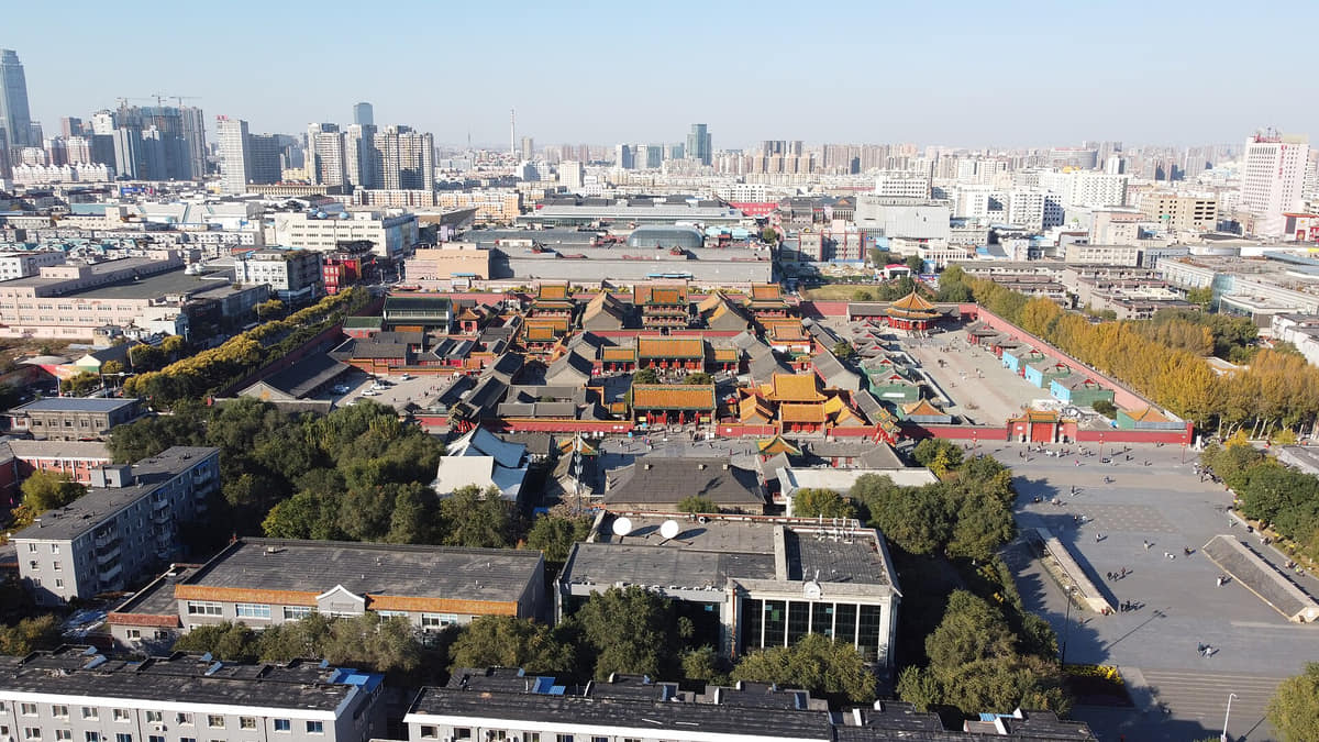
Mukden Palace inside central ShenyangPhoto: Techyan · source · CC BY-SA 4.0
Permanent residents across Shenyang's thirteen county-level units
Population figures use the administrative area and source date shown below.[6]
Climate
Humid continental monsoon climate
Summers are warm, humid, and rainy; winters are long, cold, and dry, with strong seasonal temperature contrast.
Climate describes long-term seasonal patterns; live conditions appear separately.[1][2][3][4]
Seasonal patterns
March–May
Spring
Rapid warming, wind, and dry spells make weather changeable; parks and riverfronts green quickly after a long winter.[1][2][3][4]
June–August
Summer
Warm to hot, humid weather and concentrated rainfall support green landscapes but can bring heavy storms.[1][2][3][4]
September–November
Autumn
Clearer air, crisp temperatures, and colored foliage make palace, tomb, park, and industrial walks comfortable.[1][2][3][4]
December–February
Winter
Long cold conditions, snow, wind, and heating define daily life; daylight is limited and surfaces can be icy.[1][2][3][4]
A short history of the city
Eleven evidence-led layers move from Xinle archaeology and the Liao plain through the seventeenth-century capital, palace and tombs, rail expansion, war and occupation, industrial build-out, restructuring and today's thirteen-unit municipality.
Image credits and licenses
Relief wall at the Xinle Site museumPhoto: Geraldshields11 · source · CC BY-SA 3.0
Mukden Palace inside central ShenyangPhoto: Techyan · source · CC BY-SA 4.0
Beiling Park and Zhaoling from above in 2018Photo: David290 · source · CC BY-SA 4.0
Daqinglou at the Marshal Zhang's Mansion in 2024Photo: ScareCriterion12 · source · CC0
Shenyang Railway Station in 2024Photo: E2568 · source · CC0
Xinle settlement evidence
Excavated remains at Xinle document Neolithic settlement and material culture in today's Shenyang area. They do not prove an uninterrupted city, a single ancestry line or continuity of every later custom.[15]
Liao River regional networks
Settlements, routes and changing administrative systems connected this plain with wider northeastern and north-China networks. Museum collections provide regional context, but regional objects are not automatically local city finds.[5][16]
Walled city and frontier routes
A fortified urban layer and routes across the Liao plain preceded the seventeenth-century capital. Later rebuilding altered streets and walls, so surviving alignments and reconstructed visitor areas need site-specific evidence.[5][7]
Later Jin capital
The Later Jin capital moved to Shenyang and palace construction organized a new ceremonial and administrative center. Dazheng Hall, the Ten Kings' Pavilions and later palace routes belong to related but not identical building phases.[9][10]
Palace and tomb landscape
After the Qing court moved to Beijing, Shengjing retained dynastic and ceremonial functions. The palace continued to develop across roughly 160 years, while Fuling and Zhaoling joined architecture, ritual routes, sculpture, woodland and terrain.[10][12][13]
Rail, trade and migration
Railway and commercial growth intensified movement of people, goods and capital. New infrastructure and districts did not replace the older city at once; they created overlapping centers and unequal urban conditions.[5][7]
Multiple urban institutions
Railway zones, residences, schools, offices, workshops and expanding industry produced a more complex metropolis. Architectural evidence should be read alongside ownership, labor and planning records rather than as neutral scenery alone.[5][7]
War and occupation
The Mukden Incident occurred near the city in 1931, followed by Japanese occupation and industrial expansion under colonial rule. This history requires factual chronology, documentation of coercion and loss, and avoidance of spectacle or present-day political inference.[5]
Industrial build-out
Large factories, technical systems, transport and worker housing made manufacturing central to employment and city form. The system involved many occupations and households; machinery alone cannot tell the full history of labor.[14][5]
Restructuring and reuse
Industrial restructuring changed employment, land and neighbourhood life. Museums, parks, new industries and reused sites preserve selected material traces, while losses, displacement and ongoing work require separate community and archival evidence.[14][7]
Thirteen-unit municipality
The official year-end population was 9.276 million across ten districts, two counties and Xinmin city. The same municipal statistics cover dense urban cores, eastern hills, broad agricultural land and county communities.[6][7]
People, language, and everyday rhythms
Eight perspectives describe 9.276 million permanent residents through statistical scope, language, core–county differences, manufacturing, services, migration, Korean-Chinese visibility and seasonal routines—without assigning one personality to everyone.
Population scope
The 9.276 million figure is a 2025 permanent-resident total for the entire municipality, not a downtown headcount. Urban residents numbered 7.966 million and rural residents 1.310 million in the same official report.[6][7][5][8]
Language
Standard Mandarin is widely used; local speech belongs to Northeastern Mandarin and varies by age, family, district and migration history. A familiar accent is not a personality test or evidence that everyone uses the same vocabulary.[6][7][5][8]
Core, suburbs and counties
Apartment districts, old streets, industrial neighbourhoods, university areas, eastern hills, county towns and farming communities create different daily geographies. One palace or downtown street cannot stand in for Kangping, Faku, Liaozhong or Xinmin.[6][7][5][8]
Manufacturing and technical labor
Factories, design, maintenance, logistics, research and supply chains support many forms of work. Industrial identity should include skills, safety, management, changing employment and household life—not only monumental machines.[6][7][5][8]
Education and services
Universities, hospitals, retail, transport, public administration, culture and technology expand the city's occupational profile. Their users and workers move across district boundaries, linking older cores with Hunnan and other newer areas.[6][7][5][8]
Migration and regional connection
Rail, road and air links connect Shenyang with other northeastern cities and the wider country. Residents include long-established families, students, workers, businesspeople and newer arrivals with different attachments to the city.[6][7][5][8]
Korean-Chinese visibility
Chinese–Korean signs and food businesses make Korean-Chinese cultural and commercial presence visible around Xita. They do not define every resident's identity, language, religion, household food or view of the neighbourhood.[6][7][5][8]
Seasonal routines
Long cold winters and warm humid summers shape heating, clothing, parks, markets, food storage and travel choices. Climate describes long-term patterns; heat, snow, air quality and road conditions must be checked live.[6][7][5][8]
Liaoning Provincial Museum in HunnanPhoto: Augusthaiho · source · CC BY-SA 4.0
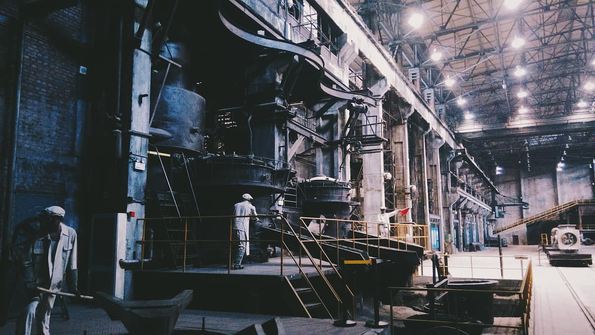
Casting-work display inside the industrial museumPhoto: Pauloleong2002 · source · CC BY-SA 4.0
Workers' Village life museum in TiexiPhoto: Augustokremo · source · CC BY-SA 4.0
Chinese–Korean signs on Xita Street in 2026Photo: TurnOnTheNight · source · CC BY-SA 4.0
Archaeology without false continuity
Xinle shows that people lived in this area about 7,200 years ago through excavated features and objects. Museum reconstructions and reliefs help interpretation but must not be treated as photographs of prehistoric life or proof of a direct line to every present resident.[15]
Three palace routes
The Shenyang palace developed through eastern, central and western architectural routes over a long construction history. Dazheng Hall and the pavilion array differ spatially from the central palace sequence and later western additions; the complex should be read in phases.[10][9]
Architecture and cultural exchange
Roof forms, hall plans, inscriptions, painted decoration and ritual arrangements reflect multiple architectural and court traditions. Specific Manchu, Han, Mongol or Tibetan references should be tied to documented elements, not generalized to the whole city or every resident.[9][12]
Mausoleum as landscape
Fuling and Zhaoling are not isolated buildings. Gates, spirit ways, stone sculpture, walls, halls, woodland, water and terrain create ceremonial landscapes whose conservation includes both architecture and setting.[13]
Conservation and visible color
Bright roofs and painted brackets are visually powerful, but present color may include maintenance, repair and replacement. Captions distinguish what the photograph shows from claims about original pigment, age and untouched fabric.[11]
Regional museum lens
Liaoning Provincial Museum connects archaeology, painting, calligraphy, ceramics and exchange across a region much larger than Shenyang. Collection labels should identify provenance; a regional object is not automatically local evidence.[16]
Industrial heritage and process
The China Industrial Museum uses reused fabric, machinery, documents and staged scenes to explain production systems. Museums interpret selected histories; they do not certify current factories, safety, labor conditions or the completeness of preservation.[14]
Worker-neighbourhood memory
Tiexi worker housing links employment, welfare, family life, schools, shops and collective memory. Recreated rooms and life museums are one source; oral history, archives and surviving residential fabric provide different evidence.[14][19]
Railway and mixed urban form
The railway station, early twentieth-century residences, industrial sites, older streets and later towers show how institutions reshaped urban form. Architectural style does not by itself explain ownership, power, labor or social access.[5][7]
Zhongjie commerce
Zhongjie layers pedestrian movement, department-store history, food brands, chains, kiosks and entertainment. Commercial reputation and historic naming are cultural evidence, but storefronts and claims must be dated and independently checked.[17][19]
Xita multilingual public life
Chinese and Korean signage, groceries, restaurants and street trade make migration and community networks visible in public space. The district is dynamic and internally diverse; visitor branding should not replace resident perspectives.[17][19]
Parks, river and public institutions
Beiling Park, the Hun River, Qipanshan, museums, universities, theatres, markets and transport spaces support contemporary public culture. Use and access vary by season, event, management and neighbourhood rather than following one citywide pattern.[7][5]
Food and local flavor
Fourteen entries move from dumpling systems, chicken frames and charcoal barbecue to Korean-Chinese neighbourhood food, morning markets, commercial reputation, allergens, traceability, labor and live food-safety checks.
Bao Fa Yuan's four-dish serving in 2015Photo: Iyoo · source · CC BY-SA 4.0
Mud-brazier barbecue meal in ShenyangPhoto: Ecabal · source · CC BY-SA 4.0
Seafood and scallion pancake served in XitaPhoto: E2568 · source · CC0
Dated Laobian dumpling storefront on ZhongjiePhoto: 阴阳权政 · source · CC BY-SA 3.0
Dumplings beyond one brand
Filled-dough families
Boiled, steamed and pan-fried dumplings vary in dough, fold, filling, stock and serving. Laobian is a visible commercial name, but brand narratives do not define all Shenyang dumplings or prove a single origin story.[17]
Frost-flower fried dumplings
Pan and lattice
A starch slurry can set into a crisp web around dumplings as water evaporates and the base browns. Ratios, pan heat, oil and timing differ; the gallery records one restaurant plate, not a protected recipe.[17]
Fried, mixed, smoked and braised forms
Chicken-frame dishes
Chicken frames appear in several snack and meal forms, often valued for seasoning, texture and informal social eating. Shop methods and origin stories vary; bones, salt, spice, oil and food handling deserve direct attention.[19]
Mud-brazier barbecue
Charcoal-table cooking
A tall brazier and mesh grill make heat and cooking visible at the table. Ventilation, fuel, raw-meat handling, separate utensils, marinades and doneness are practical variables, not decorative details.[19]
Bao Fa Yuan's four dishes
Named restaurant repertoire
The photographed set is associated with one established restaurant and combines different proteins, sauces and wok treatments. Official guides can identify reputation, but current ingredients, recipe, ownership, service and quality require direct checks.[17]
Xita tables and shops
Korean-Chinese neighbourhood food
Barbecue, cold noodles, rice dishes, kimchi, pancakes and groceries appear around Xita through Korean-Chinese and wider transregional commerce. Recipes, language, ownership and household traditions are diverse; one venue cannot represent a community.[17][19]
Batter, scallion and seafood
Seafood pancake
The photographed pancake combines batter, scallion and seafood in one Xita serving. Seafood species, egg, flour, oil and dipping sauce vary and matter for shellfish, gluten and egg allergies.[17]
Shaomai and related forms
Steamed wheat snacks
Official city food guides identify Ma-family shaomai among familiar names, but wrappers, fillings, branding and present outlets change. A historic name is not a guarantee of current recipe or continuity.[17]
Li Liangui-style bacon pie
Bacon pie networks
Smoked or seasoned meat, layered bread and accompaniments form a widely travelled regional combination. City and brand associations overlap across northeastern places, so exclusive origin claims need stronger historical evidence.[17]
Stews, pickled vegetables and grains
Northeastern shared table
Large pots, pork, chicken, fish, potatoes, cabbage, beans, corn and wheat appear in many home and restaurant combinations. These are regional systems with household variation, not foods unique to one city.[18]
Breakfast, produce and neighbourhood rhythm
Morning markets
Morning markets link breakfast stalls, vegetables, meat, staples, seasonal goods and repeat social contact. Official profiles show their popularity, while exact vendors, hygiene, price, opening and crowding must be checked live.[18]
Brands, awards and food streets
Reputation and route-making
Guides, awards and themed routes amplify chicken frames, dumplings, old restaurants and Xita food. They help discovery but do not certify authenticity, health value, fair price, ingredient origin or labor conditions.[17][19]
Ask about stock, sauce and shared equipment
Allergens and dietary requirements
Wheat, soy, sesame, peanuts, egg, dairy, seafood, meat stock, alcohol and shared oil or grills may appear. Vegetarian, vegan, halal, gluten and allergy needs require precise venue-level questions.[17][19]
Photography is not an inspection
Traceability, labor and live safety
A vivid plate cannot verify sourcing, cold chain, kitchen temperature, oil reuse, charcoal ventilation, wages, permits or sanitation. Check current labels, storage, inspections, busy-service conditions and personal health needs.[17][19]
Landmarks and architecture
Image credits and licenses
Mukden Palace inside central ShenyangPhoto: Techyan · source · CC BY-SA 4.0
Hall on the Zhaoling ceremonial axis in 2024Photo: ScareCriterion12 · source · CC0
Liaoning Provincial Museum in HunnanPhoto: Augusthaiho · source · CC BY-SA 4.0
Shenyang Railway Station in 2024Photo: E2568 · source · CC0
Hun River and Shenyang skylinePhoto: E2568 · source · CC0
A UNESCO-listed palace complex whose eastern, central and western routes developed over multiple phases. Courtyards, collections, repairs and visitor use should be read separately.[9][12]
Dazheng Hall and Ten Kings' Pavilions
The octagonal hall and pavilion array make the early eastern route spatially distinctive. Present surfaces, barriers and circulation include conservation and visitor-management layers.[10]
Zhaoling Mausoleum
A ceremonial compound of gates, halls, walls, sculpture and mound set within extensive woodland. Close details and bright paint do not replace a full conservation record.[13]
Beiling Park
A major public park in which lakes, paths, trees and everyday recreation surround the Zhaoling landscape. Park ecology and mausoleum heritage are connected but governed by different live conditions.[13][7]
Fuling Tomb
An eastern wooded tomb landscape with a long approach, gates, stone sculpture and terrain. The entrance photograph and camel detail show only parts of the sequence.[13]
Xinle Site Museum
An archaeological-site institution interpreting a Neolithic settlement through excavated evidence, collections and modern displays. Reliefs and reconstructions must be labelled as interpretation.[15]
Liaoning Provincial Museum
A regional museum in Hunnan whose collections extend far beyond Shenyang. Check current exhibitions and identify object provenance rather than assuming every display is local.[16]
Former museum and arts-center venue
A dated former institutional building retained to show museum relocation and urban cultural infrastructure. It is not the present provincial-museum exterior.[16]
China Industrial Museum
A Tiexi institution using factory-scale space, machinery, documents and staged scenes to interpret industrial systems. Museum displays are not working-factory evidence.[14]
Tiexi Workers' Village
Worker housing and a life museum connect employment, family, welfare and neighbourhood change. Recreated rooms, surviving buildings and oral history should remain distinct sources.[14][19]
Marshal Zhang's Mansion
A multi-building early twentieth-century compound including the Daqinglou. Architecture, occupants, political events, restoration and current museum use require separate records.[5]
Shenyang Railway Station
A historic-style facade incorporated into a contemporary transport hub. Architecture is visible, while services, transfers, security and accessibility are live information.[5][7]
Zhongjie
A central commercial street layering historic naming, department-store memory, current chains, local brands, kiosks and pedestrian life. A 2026 photograph is still a dated snapshot.[17][19]
Xita Street
A multilingual commercial and residential district where Chinese–Korean signs and food networks are visible. It is internally diverse and should not be reduced to a themed food street.[17][19]
Hun River corridor
A metropolitan water and public-space system involving bridges, flood management, parks, housing and civic buildings. Conditions vary by reach, season and date.[7]
Qipanshan and Lake Xiu
An eastern mountain-water landscape that challenges a flat, factory-only image of Shenyang. Trails, water, fire risk, transport and opening require current checks.[7][8]
Municipal plain and county landscapes
Liaozhong, Kangping, Faku and Xinmin connect fields, wetlands, villages, county towns and food supply with the metropolis. They are working landscapes, not empty space beyond the city.[6][7]
Ways to explore the city
Use palace, factory, museum, and river as four linked but different ways to understand Shenyang.
Early Qing city
Mukden Palace → old city streets → Zhaoling
Connect palace planning, neighborhood change, ceremonial routes, and tomb landscape.[1][2][3][4]
Industrial Shenyang
Tiexi district → Industrial Museum → worker-neighborhood context
Read factories, machinery, labor, housing, and adaptive reuse as one urban history.[1][2][3][4]
Regional collections and river
Liaoning Museum → Hun River waterfront
Move from long regional history to the contemporary cultural and public-space axis.[1][2][3][4]