
Land and water
This city-specific topic connects place, daily life, and the wider municipal landscape: Land and water.
Sichuan Province · Sichuan Province, Southwest China
Panzhihua, China, is a prefecture-level city in southwest Sichuan at the meeting of the Jinsha and Yalong rivers. Its five county-level units connect a steep industrial core with Third Line history, rail, hydropower, dry-hot-valley agriculture and mountain communities.
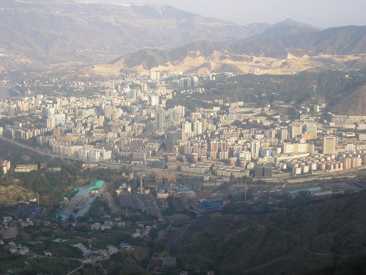
Panzhihua occupies the Sichuan–Yunnan borderlands where the Yalong River meets the Jinsha. Steep mountains, deeply cut valleys, river terraces, bridges, rail lines, industrial sites, reservoirs, farmland, and dispersed neighborhoods make geography visible in almost every daily journey.
The modern municipality grew rapidly around vanadium-titanium magnetite, steel, rail, and state-directed Third Line industrialization. A responsible account includes engineering and urban growth together with migrant labor, dangerous work, local communities, environmental costs, and the uneven experiences preserved in museums, neighborhoods, and family memory.
Panzhihua is not only its industrial core. Miyi and Yanbian add the Anning River corridor, reservoir shores, mountain settlements, orchards, early-season agriculture, and multiple community traditions; Renhe and the central districts contain historic villages, worker districts, parks, markets, and newer civic centers.
A complete exploration follows connected systems: elevation before climate, ore before steel, workers and transport before monumental industry, reservoir communities before a dam panorama, orchard labor before a mango label, living residents before heritage branding, and verifiable sources before city stereotypes.
This city-specific topic connects place, daily life, and the wider municipal landscape: Land and water.
This city-specific topic connects place, daily life, and the wider municipal landscape: Historical layers.
This city-specific topic connects place, daily life, and the wider municipal landscape: Living culture.
This city-specific topic connects place, daily life, and the wider municipal landscape: County diversity.
Eighteen rights-cleared documentary images and clearly labeled regional references connect Panzhihua's river-valley geography, industrial construction, bridges, hydropower, county landscapes, village heritage, biodiversity, agriculture, and food.
This city-specific topic connects place, daily life, and the wider municipal landscape: Jinsha River gorge.[1][2][3][4]
Four geographic relationships define Panzhihua.
This city-specific topic connects place, daily life, and the wider municipal landscape: Jinsha River gorge.[1][2][3][4]
This city-specific topic connects place, daily life, and the wider municipal landscape: Yalong River confluence.[1][2][3][4]
This city-specific topic connects place, daily life, and the wider municipal landscape: Dry-hot valleys and cool uplands.[1][2][3][4]
This city-specific topic connects place, daily life, and the wider municipal landscape: Five county-level units.[1][2][3][4]
Loading current conditions…
Forecast data: Open-MeteoPermanent residents across Panzhihua Municipality
Population figures use the administrative area and source date shown below.[1][2][3][4]Strong sun, warm winters, concentrated summer rain, and sharp elevation differences distinguish river valleys from uplands.
Climate describes long-term seasonal patterns; live conditions appear separately.[1][2][3][4]Temperatures rise quickly; rain, cloud, and local elevation call for flexible outdoor plans in Panzhihua.[1][2][3][4]
Strong sun, warm winters, concentrated summer rain, and sharp elevation differences distinguish river valleys from uplands.[1][2][3][4]
Clearer intervals and cooler evenings usually favor river, old-town, museum, and county routes.[1][2][3][4]
Damp cool conditions make layered clothing and indoor–outdoor route pairing practical.[1][2][3][4]
Nine layers move from long-lived river-valley communities through mineral surveys and Third Line industrialization to railway, steel, hydropower, heritage work, agriculture, and ecological transition.
The Jinsha, Yalong, and Anning valleys were inhabited, cultivated, traded through, and named long before large-scale steel construction. Han, Yi, Lisu, and other local histories differ by valley and settlement; the area was not an empty industrial frontier.[3][9]
Panzhihua was first a local place-name within a wider landscape of villages, county administrations, ferry points, mountain paths, farming, pastoral movement, and river trade. Modern municipal boundaries later gathered these older geographies into one city.[3][9]
Geological surveys identified large vanadium-titanium magnetite resources. Turning knowledge of the ore body into production still required transport, water, power, metallurgical research, capital, housing, and a labor force; geology alone did not create a city.[9]
National Third Line planning selected the valley for a major steel base. Administrative institutions and construction zones were established rapidly from 1965, reorganizing land, roads, work, and migration across terrain that imposed severe building constraints.[9][7]
Pangang works, mines, the Chengdu–Kunming railway, sidings, bridges, power and water systems, hospitals, schools, shops, and hillside housing were built as an interdependent network. Dispersed industrial districts produced Panzhihua's multi-center form.[9][8]
Processing vanadium-titanium magnetite required continuing metallurgical experimentation and industrial coordination. Production achievements belong alongside accounts of heat, dust, noise, shift work, occupational risk, pollution, maintenance, and family life in worker neighborhoods.[9][7]
Ertan Hydropower Station was built on the Yalong River with a 240-meter arch dam and 3.3-gigawatt installed capacity. The project created energy and infrastructure while reservoir formation, relocation, ecological change, and new shore economies reshaped local lives.[10][11]
The city is balancing steel and resource industries with cleaner production, services, transport, dry-hot-valley agriculture, biodiversity protection, museums, historic-building work, and tourism. These transitions remain active and their benefits and costs are not evenly shared.[6][14][15]
Understanding residents requires attention to migration, original communities, language, work schedules, district and county differences, and changing generations—not one steel-city personality.
Southwestern Mandarin is widely used, alongside Standard Mandarin and Yi, Lisu, and other community languages. Vocabulary, accent, literacy, and language choice vary by household, generation, education, workplace, and county.[6][9][3]
Farmers, herders, traders, craftspeople, and residents of villages and county towns had social worlds before industrial construction. Their land use, relocation, adaptation, and cultural continuity should not appear only as background to steel.[6][9][3]
Engineers, skilled workers, builders, railway crews, administrators, teachers, clinicians, and families arrived from many parts of China. Different recruitment routes, occupations, housing, status, and memories complicate any single migration story.[6][9][3]
Continuous industrial production shaped sleep, transport, canteens, childcare, healthcare, shopping, and neighborhood rhythms. These patterns changed across plants, mines, contractors, gender roles, retirement, and later industrial restructuring.[6][9][3]
Bingcaogang, Dongqu, Xiqu, Renhe, Miyi, and Yanbian differ in density, elevation, employment, farming, climate, commuting distance, public services, and cultural institutions. A municipal statistic contains many everyday geographies.[6][9][3]
Students, growers, shopkeepers, service workers, public employees, transport workers, craftspeople, retirees, new migrants, and tourism workers have distinct routines and pressures. Industrial heritage is important but does not define every resident.[6][9][3]
Twelve entries connect Panzhihua food to dry-hot-valley crops, county traditions, migration, industrial work schedules, seasonal markets, technique, and verifiable origin rather than a short list of famous dishes.
Rice noodles, lamb, broth, herbs, chile, and condiments are adjusted by shop and diner. The dish links animal husbandry, market supply, broth preparation, early opening hours, and the everyday food geography of Yanbian.[5]
Pork is cooked and stored through a fat-based preservation tradition associated with Yanbian. Cut, salting, aromatics, heating, moisture control, storage hygiene, and later reheating all matter; household and commercial versions differ.[5]
Strong sun, elevation, slope, irrigation, cultivar, flowering, ripening, harvest timing, sorting, transport, and branding shape the fruit. The name covers multiple producers and cultivars, so provenance and season matter more than a generic image.[12][5]
Warm valleys and varied elevation can bring tomatoes and other vegetables to market at different times. Seed choice, protected cultivation, irrigation, labor, quality grading, logistics, prices, and water use belong to the food story.[12][5]
Other warm-climate fruits extend the municipal harvest beyond mango. Each crop occupies different slopes, soils, irrigation schedules, picking windows, packing needs, and market channels; no single fruit represents all county agriculture.[5]
A metal pot supports layered or simmered meats, vegetables, mushrooms, tofu, and broth around a shared table. Ingredient order, heat control, portioning, dipping sauces, season, and group size shape the meal more than the vessel's visual novelty.[5]
Cuts of meat, skewers or grates, salt, chile, aromatics, smoke, fire control, and communal serving vary among households, stalls, restaurants, and events. The label should not flatten distinct Yi communities into one recipe.[5]
Freshness, species, legal source, cleaning, bones, cooking method, chile, herbs, and broth determine the dish. Culinary reputation must be separated from protected wildlife, fishing restrictions, aquaculture records, and food-safety rules.[5]
Salting, drying, smoking or fat storage concentrate flavor and extend keeping time. Temperature, humidity, ventilation, cleanliness, cut size, and present-day refrigeration alter practices across mountain and valley households.[5]
Tender shoots, leafy vegetables, herbs, and fungi can reflect detailed local knowledge, but accurate identification and lawful, sustainable sourcing are essential. Restaurant names alone are not proof that an ingredient is safe or wild.[5]
Fresh and dried chile, fermented bean or chile pastes, garlic, ginger, peppercorn, pickles, herbs, oil, salt, and sour notes are combined differently across migrant, county, home, canteen, and restaurant cooking.[5]
Industrial shifts encouraged fast breakfasts, canteen meals, portable dishes, late service, and neighborhood markets. Migrants carried techniques from elsewhere and adapted them to local crops, prices, schedules, and household tastes.[6][5]
Three routes pair the core city with contrasting county-level landscapes.
Panzhihua explains how ore, national industrial planning, rail, hydropower, migrant labor, and difficult terrain produced a dispersed city.
Read the story