A Gan River capital where literary memory, Han archaeology, modern history, rice-based foodways, provincial institutions, wetlands, and rapid two-bank growth meet.
Gan River, Tengwang Pavilion, Jiangxi Provincial Museum, Haihunhou archaeology, modern historical memory, rice noodles, and cross-river growth[1][2][3][4]
Guide scope
Nine county-level units spanning the historic east bank, new west-bank center, river islands, industrial zones, wetland plain, counties, and western hills[1][2][3][4]
Understand Nanchang through river, province, and repeated reconstruction
Nanchang is a nine-unit municipality on the lower Gan River: Donghu, Xihu, Qingyunpu, Qingshanhu, Xinjian and Honggutan districts, plus Nanchang, Anyi and Jinxian counties. The city spans a two-bank urban core, low water-rich plains, lakes and wetlands, agricultural counties and the western Meiling uplands; the map therefore reaches beyond the famous central landmarks.
Its history is not one monument or one twentieth-century episode. Haihunhou archaeology supplies Western Han settlement and burial evidence; Tengwang Pavilion joins a 653 foundation with literature and repeated reconstruction; pagodas, temples, villages, residences, art museums, historic streets, rail and river infrastructure add distinct material timelines.
The municipality has a humid subtropical monsoon climate. Long hot and rainy summers, frequent warm-season storms, a generally clearer and drier autumn and occasional cold, freezing, drought or flood episodes shape daily life. Climate is a long-term pattern: live temperature, heavy-rain warnings, river level, heat risk, air quality and route safety must come from current services.
The official end-2024 permanent-resident population was 6.6704 million for the full municipality. This total must not be substituted for registered population, built-up-area residents, commuters, students, tourists or a metropolitan estimate, and it does not erase differences between old east-bank neighbourhoods, Honggutan, industrial corridors, county towns, villages and wetland-edge communities.
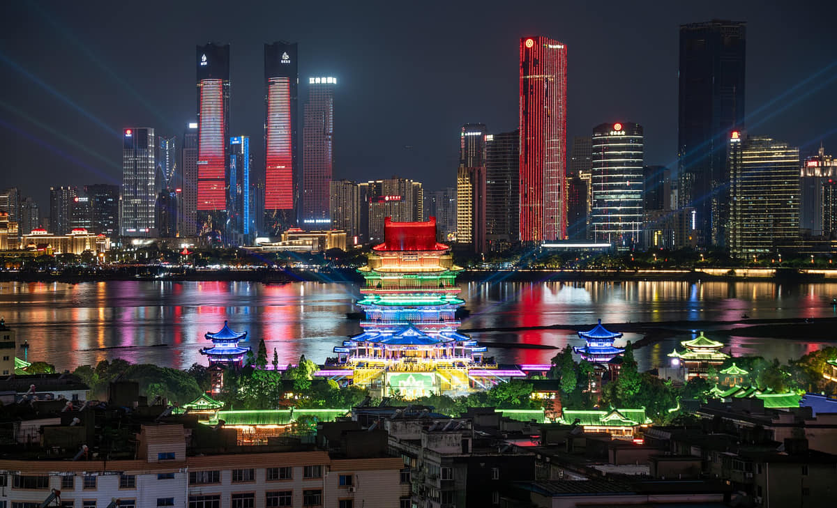
Tengwang Pavilion shows how texts, rebuilt architecture, landscape, and tourism sustain memory.
Provincial gateway
Museums, universities, hospitals, transport, markets, and migration connect Nanchang to all of Jiangxi.
Wetland plain
Poyang-connected water systems place the city inside a wider ecological and agricultural landscape.
A visual record of the city
Twenty-seven locally hosted, rights-cleared images connect the Gan River, two-bank skyline, reconstruction, archaeology, civic and conflict-history sites, provincial collections, historic districts, county villages, living religion, transport and five food settings. Every caption separates visible evidence from current conditions, institutional interpretation, political endorsement, recipe claims and food safety.
Image credits and licenses
Tengwang Pavilion and the two-bank cityPhoto: Akira CA · source · CC BY-SA 4.0
Rice noodles and clay-pot soup, 2015Photo: Qa003qa003 · source · CC BY-SA 4.0
Meat curing at a window, 2016Photo: Gary Todd from Xinzheng, China · source · CC0
Location, boundary, and 3D buildings
The urban core occupies both banks of the Gan River, while the municipality extends through a low water-rich plain toward lakes, agricultural counties, wetlands, and the western hills.[1][2][3][4]
The Gan River, Poyang-connected plain, wetlands, islands, western hills, and nine-unit municipality define Nanchang.
Gan River corridor
Nanchang straddles the Gan River near its lower course, where bridges, levees, islands, ports, and flood management organize the metropolis.[1][2][3][4]
Poyang Lake plain
The city lies near the Gan River's route into Poyang Lake, within a low, water-rich plain of wetlands, fields, lakes, and seasonal hydrology.[1][2][3][4]
Western hills
Meiling and the western uplands provide forest, reservoirs, temples, villages, and cooler terrain close to the urban basin.[1][2][3][4]
Municipal scale
Six districts and three counties cover dense riverfront centers, industrial zones, towns, agricultural plains, wetlands, and mountain edges.[1][2][3][4]
Permanent residents across Nanchang's six districts and three counties; do not mix with registered-population, built-up-area, visitor or metropolitan estimates
Population figures use the administrative area and source date shown below.[5][6]
Climate
Humid subtropical monsoon climate
Summers are long, hot, humid, and rainy; winters are cool and damp, while spring rain and autumn clarity shape seasonal use.
Climate describes long-term seasonal patterns; live conditions appear separately.[1][2][3][4]
Seasonal patterns
March–May
Spring
Rapid warming, humidity, and frequent rain make museum, old-city, riverfront, and mountain plans weather-dependent.[1][2][3][4]
June–August
Summer
Long hot humid periods, thunderstorms, and heavy rain favor shade, hydration, indoor breaks, and caution near water.[1][2][3][4]
September–November
Autumn
Drier and often clearer weather suits long Gan River walks, county archaeology, lakes, and western hills.[1][2][3][4]
December–February
Winter
Cool, damp spells occur without reliable central heating; combine exposed waterfronts with museums and food stops.[1][2][3][4]
A short history of the city
Eleven sourced layers move from settlement in a water-rich plain and Western Han Haihunhou archaeology through more than 2,200 years of urban history, the 653 pavilion, pagoda and religious landscapes, county architecture, early modern transport, the dated 1927 conflict, provincial institutions and contemporary two-bank growth.
Image credits and licenses
Haihunhou site museumPhoto: Cjsy2026 · source · CC0
A 1670 image of Tengwang PavilionPhoto: Huang Yingchen · source · Public domain
Nanchang street postcard from the 1920sPhoto: Unknown photographer · source · Public domain
Jiangxi Provincial Museum exterior, 2019Photo: Liuxingy · source · CC BY-SA 4.0
Settlement in a changing water landscape
Archaeology and regional geography place human settlement within the Gan–Fu river system, lake margins and the Poyang-connected plain before the historical city took its later form. Water routes, wetlands, floodplain shifts and farming shaped opportunities and risk; modern municipal borders should not be projected backwards.[7][12]
Haihunhou state, settlement and cemeteries
The Haihunhou archaeological landscape includes the Zijin city site, cemetery groups and extensive excavated material. It provides evidence for an elite polity, administration, craft, writing, exchange and mortuary practice, while museum displays, restored routes and digital reconstructions must be separated from excavated contexts.[10]
Yuzhang and the developing regional centre
The municipal profile describes more than 2,200 years of urban history. Administrative names, walls, settlements and centres changed repeatedly, so written chronology, archaeology, place-name traditions and today's urban footprint are related but not interchangeable evidence.[6][12]
Hongzhou and the first Tengwang Pavilion
Official records place the first Tengwang Pavilion in 653. Wang Bo's later celebrated prose made the pavilion and its river view a widely circulated literary landscape, but text, historical building, later images and the present 1989 reconstruction are four different kinds of evidence.[9]
Shengjin Pagoda and changing city form
Shengjin Pagoda was founded in 904–907 according to official conservation records, then rebuilt and repaired across later periods. Its survival should be read through documented interventions, adjacent neighbourhood change and the difference between a protected monument and recently constructed historic-style streetscape.[16][11]
Bada Shanren and Qingyunpu
Zhu Da, known as Bada Shanren, worked in the upheavals of the Ming–Qing transition and became a major painter and calligrapher. Qingyunpu today combines a historic religious site, conserved architecture, collections and a museum founded in 1959; none of those layers alone is the artist's complete biography.[14]
Wangshan Tuku, villages and building craft
Wangshan Tuku, begun in 1821 according to the municipal intangible-heritage account, and the village ensembles of Anyi make household organisation, timber-and-brick construction, drainage, carving, lineage, commerce and rural labour visible. Elite residences should be read together with builders, servants, farmers and changing resident use.[18][15]
Transport, commerce and changing streets
Steam transport, rail, industry, schools, commerce, warfare and municipal works altered the river city. The 1920s postcard is a useful published trace of one street scene, but exact location, retouching and editorial choices need archival corroboration rather than nostalgic assumptions.[12][26]
Nanchang Uprising and its sites
The armed uprising of 1 August 1927 is a dated episode in China's civil and military history and is central to later state commemoration in Nanchang. The memorial institution manages five protected sites; conflict events, surviving architecture, restored rooms, museum narrative and contemporary civic symbolism should be labelled separately and neutrally.[13]
Provincial institutions, industry and reconstruction
Provincial-capital administration, factories, universities, railways, housing and public institutions expanded the city. The current Tengwang Pavilion completed in 1989 is one visible product of heritage reconstruction during this period; it continues older memory without becoming original Tang material.[9][6]
Two-bank growth and evidence-based conservation
Bridges, Honggutan, metro lines, museums, station upgrades, parks and riverfront construction have reorganised the metropolis, while official plans identify historic districts, villages and structures for conservation. End-2024 permanent residents totalled 6.6704 million across six districts and three counties; urban change remains uneven within and between them.[5][6][11]
People, language, and everyday rhythms
Eight perspectives describe 6.6704 million end-2024 permanent residents through statistical scope, nine local contexts, language, two-bank mobility, labour, migration, climate routines and an explicit rejection of a single city personality.
Population with a defined scope
The 6.6704 million figure is the official end-2024 permanent-resident count for the full municipality. Registered residents, built-up-area population, students, commuters, migrant workers, visitors and metropolitan estimates answer different questions and must not be substituted.[5][6][7][8]
Nine local contexts
Six districts and three counties include old east-bank neighbourhoods, Honggutan's newer centre, industrial corridors, lake-edge districts, county towns, agricultural plains, historic villages and western uplands. Work, housing, transport and public services vary inside every unit too.[5][6][7][8]
Language without a purity test
Standard Mandarin is widely used, while local speech belongs to Gan-language traditions and varies by district, county, generation, family and migration history. Accent or fluency should be documented, not used to decide who counts as an authentic Nanchang resident.[5][6][7][8]
A two-bank daily city
Bridges, metro lines, buses, ferries or boats where available, walking and private vehicles connect housing, study, work, shopping and recreation across the Gan River. Travel time, accessibility, congestion and flood-related restrictions are current conditions, not stable city traits.[5][6][7][8]
Provincial gateway and labour
Government, education, health care, museums, retail, hospitality, logistics, construction, manufacturing, food service, technology and care work sustain the capital. A landmark-led guide becomes more accurate when maintenance workers, cooks, drivers, craftspeople, farmers and service staff remain visible.[5][6][7][8]
Students, migration and changing neighbourhoods
Universities, new employment, county-to-city movement, interprovincial migration, return migration and commuting change where people live. One annual population total cannot show housing pressure, duration of residence, household registration, displacement or neighbourhood turnover.[5][6][7][8]
Water and climate routines
Shade, hydration, air conditioning, rain protection, drainage awareness and checking heavy-rain or heat warnings are ordinary adaptations. Needs differ by health, age, disability, occupation, housing, income and distance from the river, lakes or hills.[5][6][7][8]
No single city personality
Literary memory, spicy breakfasts, riverside skylines and official commemorative branding are visible parts of Nanchang, but none defines every resident. Political labels, food preferences, pace of life, income, occupation and connection to famous sites remain personal and unequal.[5][6][7][8]
Culture and daily life
Image credits and licenses
Bada Shanren Memorial Hall entrancePhoto: Zhangzhugang · source · CC BY-SA 4.0
Double-sided bronze head in the provincial museumPhoto: RoundNoName · source · CC BY 4.0
Carved fabric at Wangshan TukuPhoto: Zhangzhugang · source · CC BY-SA 4.0
Gan-language life
Local speech continues through families, markets, theatre, storytelling, humour, broadcasting and digital media, with substantial variation across the municipality. Language change is a social history, not evidence that younger or migrant residents are less authentic.[19][6]
Tengwang Pavilion as literary geography
Architecture, the Gan River, Wang Bo's prose, school recitation, calligraphy, painting, rebuilding and tourism jointly maintain the landmark. Literary fame does not prove architectural continuity; the present pavilion is explicitly a 1989 reconstruction.[9]
Bada Shanren and ink painting
The painter's compressed forms, brushwork and changing identities are studied through surviving works, inscriptions, provenance and scholarship. Qingyunpu adds a historic place and museum context, while later admiration and display should not be mistaken for the artist's own voice.[14]
Porcelain-panel painting
This nationally listed practice combines drawing or painting with ceramic surfaces, pigments and firing, and developed a strong portrait tradition in Nanchang. Workshop technique, maker attribution, industrial blanks, pigments, kiln process, restoration and contemporary design need object-level records.[20][19]
Nanchang Qingyin
The official municipal overview lists Nanchang Qingyin among national representative intangible-heritage items. Vocal style, instruments, repertory, performers, venues, transmission and contemporary adaptation should be described through living practitioners rather than reduced to a static label.[19]
Tea-picking opera
Nanchang tea-picking opera is identified by the municipal overview at provincial representative level. Performance combines local speech, singing, instrumental practice, roles, movement, costume, troupes and audiences; provincial status should not be misstated as national status.[19]
Wengang brush making
Wengang's nationally listed brush-making practice links hair selection, sorting, binding, shaping, handles, inscriptions, trade and calligraphic use. A finished brush does not reveal material species, legal sourcing, maker, workshop conditions or performance without documentation.[19]
Temple fairs and community belief
The official overview lists the Xishan Wanshou Palace temple fair as a national representative item. Architecture, worship, processions, markets, performance, management and tourism are related but distinct; present practice varies and must be represented without ranking or endorsing belief.[19]
Shangban Guandi lantern
The nationally listed Lantern Festival practice in the Wanli area uses linked bench-lantern forms, collective movement and village organisation. Participation, gender and age roles, route, safety, religious meaning and contemporary performance require community-specific evidence.[25][26][10]
Museums and material evidence
Jiangxi Provincial Museum, Nanchang Museum, Haihunhou and specialist institutions connect the capital to archaeology, ceramics, bronze, documents, ecology, art and social history. Original context, provenance, replica, loan, conservation and curatorial interpretation must be labelled separately.[12][17]
Living religious sites
Youmin Temple, Qingyunpu, Wanshou Palace and other Buddhist, Daoist and popular-religion places have different histories and current uses. Belief, ritual, architecture, conservation, community service, tourism and visitor etiquette are separate dimensions.[11][12]
Conservation without false antiquity
Nanchang's heritage includes excavated sites, surviving fabric, repaired monuments, reconstructed landmarks, adaptive reuse, museum display, historic-style new construction and inhabited neighbourhoods. Clear labels allow continuity to be valued without calling every old-looking surface ancient.[11][12][9]
Food and local flavor
Fourteen entries explain rice-noodle production, mixed and fried noodles, clay-pot soup, their breakfast pairing, white sugar cake, spicy lotus root, shuizhu dishes, fried skewers, Zongshan noodles, freshwater foods, chilli and curing through technique, variation, provenance, allergens, dietary needs and current food safety.
Rice noodles and clay-pot soup, 2015Photo: Qa003qa003 · source · CC BY-SA 4.0
Meat curing at a window, 2016Photo: Gary Todd from Xinzheng, China · source · CC0
Nanchang rice noodles
Rice-noodle base
Rice noodles provide a flexible base for mixing, stir-frying and soup preparations. Rice variety, milling, extrusion, drying, soaking and texture vary by producer; the name alone does not prove local manufacture, protected technique or gluten-free handling.[23]
Chili, oil, soy-based seasoning, preserved vegetables, scallion, peanuts, sesame, meat or egg can be mixed through cooked rice noodles in different combinations. Heat, salt, allergens, pork, cross-contact, portion and price must be confirmed at the venue.
High heat, oil and rapid tossing can combine rice noodles with egg, meat, vegetables, sprouts and sauces. Wok aroma is not a fixed recipe; wheat-containing sauces, shared pans, oil condition, smoke, allergens and food safety vary.
Small ceramic vessels are associated with slow heating of broth and varied meat, egg, root, mushroom or other ingredients. The municipal project was recognised at city level in 2014 and provincial level in 2017; heritage status is not proof of medicinal benefit or safety.
Mixed rice noodles and clay-pot soup are documented by the municipality as a common breakfast combination. Frequency, shop hours, portion, chili and soup contents differ; one photograph or official food story cannot make the pairing universal for every resident.
A pale rice-based sweet cake is associated with fermentation, steaming or frying in different versions, producing a soft or lightly crisp texture. Sugar, oil, leavening, wheat cross-contact, storage and exact local recipe require vendor confirmation.
Local menus use the broad term shuizhu for ingredients cooked or finished in highly seasoned liquid or oil, but recipes and regional influences differ. Fish, meat, offal, soy, chili, pepper, oil, bones and serving temperature need dish-level checks.
Skewered vegetables, tofu products, meat or processed items are fried and seasoned to order in many shops. Shared oil and equipment create cross-contact; ingredient identity, thawing, cooking temperature, allergens, additives and hygiene require direct verification.
Anyi's Zongshan noodles add a county-level production story to the metropolitan food map. Raw rice, water, processing, drying, workshop scale and cooking differ by producer; official cultural value should not be converted into unsupported digestive or medical claims.
The Gan–Poyang water system connects the table with fish, shrimp, snails, lotus root and aquatic vegetables, but every product has a species and source. Wild or farmed status, closed seasons, legality, contaminants, bones, cold chain and sustainability need current product evidence.
Fresh and dried chili, pickled vegetables, fermented beans, garlic and aromatic oils can build direct, salty, sour or hot flavours in household and restaurant cooking. Heat preference is personal; sodium, fermentation, additives and safe storage vary.
Households and producers may cure or air-dry meats in suitable weather, linking season, preservation and flavour. Meat species, salt, nitrite, smoking, humidity, pests, cooking and storage determine safety; a picturesque window scene proves none of them.
Rice, pork, beef, poultry, freshwater fish, shellfish, egg, soy, wheat sauces, sesame, peanut, mushrooms, chili, alcohol seasoning and shared fryers or woks occur across Nanchang dining. Confirm allergies, vegetarian or religious needs, cross-contact, storage, cooking and current inspection with the venue; photographs never certify safety.
Bayi Bridge over the Gan River, 2021Photo: Vnana · source · CC BY-SA 4.0
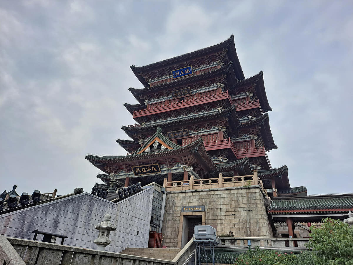
Tengwang Pavilion
A river landmark founded in 653 and repeatedly rebuilt. The current structure was completed in 1989; its value combines documented reconstruction, Wang Bo's literary afterlife, views, museum interpretation and public use rather than untouched Tang fabric.[9]
Gan River and cross-river bridges
The river is Nanchang's primary metropolitan section: islands, levees, old and new centres, bridges, parks, water supply, navigation and flood response meet here. Water level, closures, currents, weather and safety require live information.[7][8]
Bayi Square
A central civic space combining a memorial monument, ceremony, transit, commerce, landscaping and everyday movement. Its association with official historical memory should be described factually; visiting or including it does not endorse a political position.[13][11]
Nanchang Bayi Uprising Memorial Hall and five sites
A specialist institution established in the 1950s around protected buildings associated with the 1927 uprising. Conflict chronology, building history, restored rooms, objects, replicas and present exhibition narrative need separate labels and neutral language.[13]
Jiangxi Provincial Museum
A provincial institution that places Nanchang within much wider histories of Jiangxi archaeology, bronze, ceramics, art, documents, ecology and social life. Object provenance and current exhibitions matter more than treating every collection as locally excavated.[25]
Haihunhou archaeological park and museum
A large protected Western Han settlement-and-cemetery landscape in Xinjian District with a museum, excavated contexts and conservation infrastructure. Site, object, reconstruction, multimedia and visitor routes should not be collapsed into one spectacle.[10]
Bada Shanren Memorial Hall
A museum and historic religious-site landscape centred on Zhu Da's art and later reception. Surviving architecture, later restoration, genuine works, attributed works, loans and contemporary exhibitions require distinct evidence.[14]
Wanshou Palace historic district
An old-city district where protected buildings, restored or reconstructed fabric, worship, commerce, food, performance and tourism overlap. The district is living and managed; facade style alone cannot establish age or continuity.[17][11]
Shengjin Pagoda historic district
A pagoda founded in the late Tang period sits within a district reshaped by later construction, conservation and non-heritage programmes. Read the monument, street network, new historic-style fabric and intangible-heritage displays as separate layers.[16][17]
Youmin Temple
A living Buddhist place in the central city whose history, architecture, worship, visitor etiquette and current opening require separate, respectful documentation. Exterior photography cannot establish original fabric or internal practice.[12]
Anyi Ancient Villages
Luotian, Shuinan and Jingtai form a county heritage landscape with more than one hundred documented Ming–Qing buildings according to the county profile. Residents, lanes, drainage, agriculture, commerce, repair and tourism are part of the story, not background scenery.[15][12]
Wangshan Tuku
A large Qing-period residential complex begun in 1821, notable for connected halls, courtyards, brick-and-timber construction, carving and environmental adaptation. Elite family history should be balanced with building labour and later community use.[18][12]
Star of Nanchang
A contemporary observation wheel that helps orient the west-bank riverfront and the scale of cross-river development. Operations, views, ticketing, weather, maintenance, lighting and accessibility change and require current operator information.[7]
Yaohu Lake
A large eastern water landscape linking university districts, development, recreation, flood processes and ecology. Administrative edges, habitat, water quality, events, boating or swimming rules and construction are dynamic.[7][8]
Meiling and the western uplands
Forested relief, reservoirs, villages, religious places, roads and recreation provide a cooler and steeper counterpoint to the low plain. Weather, fire controls, slope, trail maintenance, transport and opening require current checks.[7][8]
Four Lakes historic character area
East, West, South and North lakes connect old-city hydrology, gardens, streets, institutions and social memory. The official historic-area listing identifies a conservation landscape, not proof that every surrounding structure is old or protected.[11]
Nanchang Railway Station
A major transport gateway whose architecture and forecourt document one phase of metropolitan mobility. Current routes, entrances, security, crowding, construction, accessibility and travel rules must come from railway operators.[6][7]
Ways to explore the city
Use the Gan River as the spine, then add provincial collections, county archaeology, and a western landscape to avoid a center-only view.
River and literature
Tengwang Pavilion → Gan River walk → west-bank night view
Connect classical text with real hydrology, bridges, reconstruction, and contemporary metropolitan space.[1][2][3][4]
Provincial deep time
Jiangxi Provincial Museum → Haihunhou Museum
Move from province-wide collections to an archaeological site and its conservation, research, and county landscape.[1][2][3][4]
Center to mountain edge
Bayi Square → neighborhood meal → Meiling
Compare central memorial space and everyday food with the forest, reservoirs, villages, and relief west of the city.[1][2][3][4]