Published and indexedVersion 1.1.0

Mianyang 绵阳

Sichuan Province · Sichuan Province, Southwest China

A Fu River city where science institutions, electronics, Li Bai literary memory, Qiang cultural landscapes, earthquake reconstruction, northern mountains, and basin agriculture intersect.

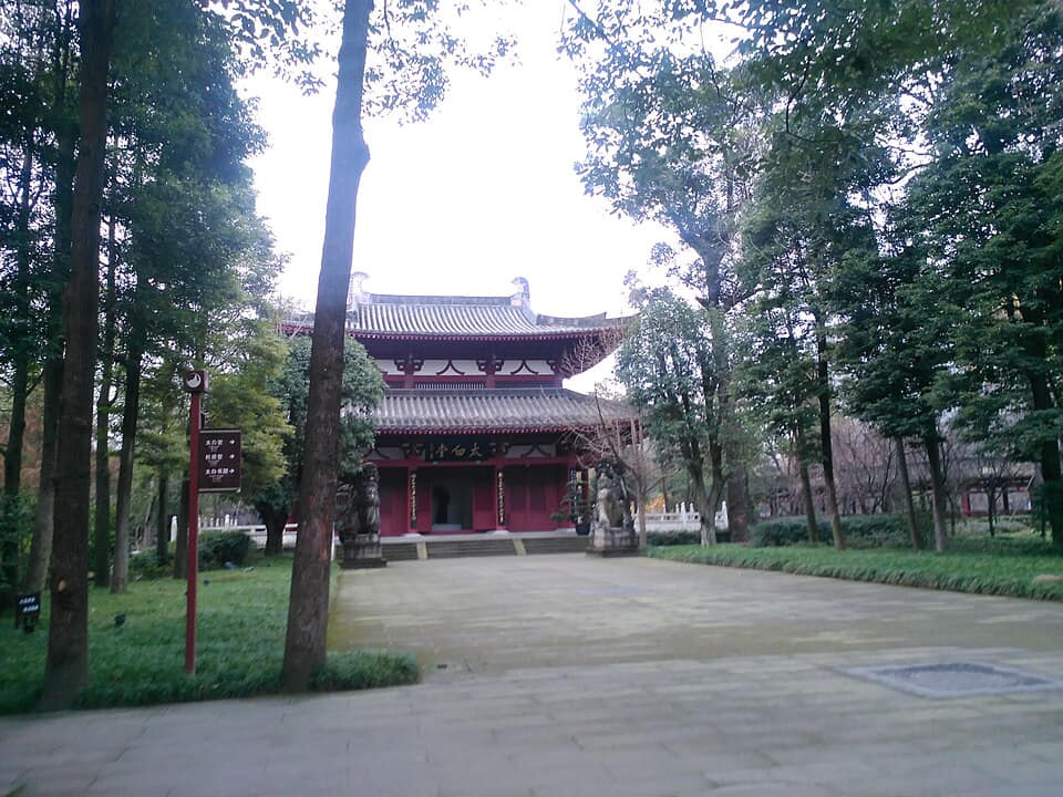
Li Bai Memorial Hall in Jiangyou, Mianyang
Photo: 沧海夜风 · source · CC BY-SA 4.0

At a glance

Region
Sichuan Province[1][2][3][4]
Administrative type
3 districts, 4 counties, 1 autonomous county, and 1 county-level city[1][2][3][4]
Time zone
China Standard Time (UTC+8)[1][2][3][4]
Population
4.922 million(End of 2024)[1][2][3][4]
Climate
Humid subtropical monsoon climate with mountain variation[1][2][3][4]
Guide scope
Complete municipal coverage across 3 districts, 4 counties, 1 autonomous county, and 1 county-level city[1][2][3][4]

Understand Mianyang through connected city and county landscapes

Mianyang occupies a long transition from the Sichuan Basin around the Fu River to the Longmen Mountains in the north. Its nine county-level units contain dense urban neighborhoods, farmland, research campuses, county towns, fault-zone landscapes, forests, villages, and very different travel times.

Its science-city reputation comes from institutions, technical workers, universities, electronics and manufacturing, planning, education, laboratories, and public science—not from a single futuristic skyline. Some operating sites have access, safety, or confidentiality limits and should not be treated as attractions.

The municipality also holds a layered cultural geography: Jiangyou's Li Bai memory, Zitong's Qiqushan and scientific-industrial heritage, Pingwu's Bao'en Temple and mountain livelihoods, Beichuan's Qiang communities and earthquake memorial landscape, and everyday Fu River life in the central city.

A complete exploration therefore connects evidence and people: read poems with historical records, buildings with conservation files, laboratories with workers and education, living heritage with community choice, disaster sites with dignity, and famous dishes with ingredients, labor, safety, and county markets.

Land and water

This city-specific topic connects place, daily life, and the wider municipal landscape: Land and water.

Historical layers

This city-specific topic connects place, daily life, and the wider municipal landscape: Historical layers.

Living culture

This city-specific topic connects place, daily life, and the wider municipal landscape: Living culture.

County diversity

This city-specific topic connects place, daily life, and the wider municipal landscape: County diversity.

Location, boundary, and 3D buildings

This city-specific topic connects place, daily life, and the wider municipal landscape: Fu River corridor.[1][2][3][4]

Loading city geometry…
County boundaries: © OpenStreetMap contributors · ODbL

Geography and the shape of the city

Four geographic relationships define Mianyang.

Fu River corridor

This city-specific topic connects place, daily life, and the wider municipal landscape: Fu River corridor.[1][2][3][4]

Basin-to-mountain transition

This city-specific topic connects place, daily life, and the wider municipal landscape: Basin-to-mountain transition.[1][2][3][4]

Longmen fault-zone context

This city-specific topic connects place, daily life, and the wider municipal landscape: Longmen fault-zone context.[1][2][3][4]

Nine county-level units

This city-specific topic connects place, daily life, and the wider municipal landscape: Nine county-level units.[1][2][3][4]

Weather now

Loading current conditions…

Forecast data: Open-Meteo

Population

4.922 million

Permanent residents across Mianyang Municipality

Population figures use the administrative area and source date shown below.[1][2][3][4]

Climate

Humid subtropical monsoon climate with mountain variation

Basin summers are warm and humid; northern mountains are cooler, wetter, and vertically varied.

Climate describes long-term seasonal patterns; live conditions appear separately.[1][2][3][4]

Seasonal patterns

March–May

Spring

Temperatures rise quickly; rain, cloud, and local elevation call for flexible outdoor plans in Mianyang.[1][2][3][4]

June–August

Summer

Basin summers are warm and humid; northern mountains are cooler, wetter, and vertically varied.[1][2][3][4]

September–November

Autumn

Clearer intervals and cooler evenings usually favor river, old-town, museum, and county routes.[1][2][3][4]

December–February

Winter

Damp cool conditions make layered clothing and indoor–outdoor route pairing practical.[1][2][3][4]

A short history of the city

Nine evidence-led layers connect Fu River settlement and county routes with Li Bai's literary geography, Ming architecture, market towns, scientific-industrial construction, the 2008 earthquake, reconstruction, and today's diverse municipality.

Image credits and licenses
  1. Fu River and mountain corridors

    River terraces, tributaries, passes, fields, and archaeological records indicate long settlement and exchange. Today's municipality should not be projected unchanged onto ancient landscapes.[3]

  2. County seats, routes, and regional administration

    Places along the Fu River and northern mountain routes were repeatedly organized through changing counties, markets, postal and transport networks, irrigation, religious sites, and local institutions. Names, boundaries, and functions changed over time.[3]

  3. Li Bai and Jiangyou's literary geography

    Li Bai's youth is strongly associated with Qinglian and Jiangyou. Poems, later biographies, inscriptions, reconstructed sites, place memory, scholarship, and tourism must be distinguished while being read together.[14][16]

  4. River markets and county landscapes

    County towns, ferries, roads, temples, schools, markets, farms, workshops, mountain products, and household networks linked the basin edge with northern valleys. No single route or monument explains this long period.[3]

  5. Bao'en Temple and Qiqushan building traditions

    Bao'en Temple was built from 1439 to 1460 and preserves early-Ming official-style architecture, painting, and sculpture. Qiqushan's multi-period complex and ancient cypresses record another route of building, ritual, study, and stewardship.[10][27]

  6. Market towns, schools, workshops, and new institutions

    River traffic and roads supported grain, tea, timber, medicinal materials, household goods, craft, education, and changing public institutions. County experiences varied by terrain and access rather than following one urban timetable.[3]

  7. Scientific, defense, electronics, and industrial construction

    Institutions and workers moved into and expanded around Mianyang and Zitong. Laboratories, factories, housing, schools, utilities, secrecy, family life, safety, and environmental management created a scientific-industrial landscape with achievements and social costs.[13][18]

  8. Earthquake loss, rescue, relocation, and rebuilding

    The Wenchuan earthquake devastated Beichuan and other parts of Mianyang. Memorial sites, museums, new towns, restored heritage, housing, schools, roads, livelihood programs, hazard planning, and survivor testimony record different parts of loss and rebuilding.[23][20]

  9. A science city within a diverse municipality

    Research, higher education, electronics, manufacturing, agriculture, public services, river management, heritage conservation, cultural tourism, mountain ecology, disaster preparedness, and county development now overlap. Their benefits and tradeoffs require continuing evidence.[12][2][1]

People, language, and everyday rhythms

Six perspectives describe language, scientific and industrial labor, literary and museum work, living Qiang communities, reconstruction generations, and the distinct daily geography of nine county-level units.

Language and communication

Southwestern Mandarin and Standard Mandarin are widely used, with variation among the central city, Jiangyou, basin counties, Beichuan, and northern mountain communities. Qiang languages and other community speech require speaker-led documentation rather than outsider labels.[3][9]

Scientific and industrial workers

Researchers, engineers, technicians, factory workers, administrators, maintenance teams, cleaners, safety staff, suppliers, educators, and families sustain the science-city system. Institutional narratives should not erase routine labor or the constraints of confidential work.[13][12]

Literary and museum workers

Editors, scholars, translators, conservators, guides, librarians, teachers, archivists, gardeners, and visitors continually remake Li Bai and local-history interpretation. Different textual or historical conclusions should remain visible.[14][17]

Qiang communities

Qiang residents are contemporary people with varied occupations, languages, beliefs, aesthetics, migration histories, and views on heritage. Festivals, embroidery, towers, museums, or reconstructed villages are meaningful parts, but none can define everyone.[5][9]

Reconstruction generations

Survivors, rescue workers, relocated households, children born after 2008, builders, planners, teachers, health workers, memorial staff, and new residents relate differently to disaster and recovery. Consent, privacy, grief, and the right not to narrate must be respected.[23][20]

Nine county-level geographies

Fucheng, Youxian, Anzhou, Santai, Yanting, Zitong, Beichuan, Pingwu, and Jiangyou differ in density, elevation, transport, work, crops, schools, healthcare, language detail, hazard exposure, and connections beyond Mianyang.[2][1]

Culture and daily life

Image credits and licenses
  • Li Bai Memorial HallPhoto: WhisperToMe · source · CC0
  • A garden for reading and remembrancePhoto: WhisperToMe · source · CC0
  • Beichuan Qiang Folk MuseumPhoto: WhisperToMe · source · CC0
  • Jina Qiang VillagePhoto: liuzusai刘祖赛 · source · CC BY 3.0

Li Bai through texts and places

Poems, editions, historical biographies, Qinglian and Jiangyou place memory, inscriptions, memorial buildings, museum collections, translations, school curricula, and tourism belong to different evidence layers; responsible interpretation does not collapse them into one origin legend.[14][16]

Literary scholarship and public reading

Research centers, libraries, conferences, recitation, calligraphy, publishing, translation, digital archives, gardens, and classroom reading keep Li Bai present. Scholarship should show disputed dating, attribution, and geography instead of hiding uncertainty.[15][16]

Qiang New Year as living heritage

Community gatherings, ritual, food, dress, music, dance, language, kinship, teaching, scheduling, public programs, tourism, and individual belief vary by place and year. Participation and representation should follow community decisions.[8][9]

Qiang embroidery and livelihood

Pattern, cloth, thread, color, stitch, learning, personal invention, household use, cooperative work, pricing, attribution, copyright, tourism demand, and online sales connect textile skill to contemporary livelihoods. A maker's name and consent matter.[6][7]

Language, song, and oral knowledge

Stories, songs, place names, agricultural and ecological vocabulary, family memory, ritual speech, recordings, orthography, translation, education, migration, and speaker numbers shape transmission. Public documentation must not expose restricted or private knowledge.[5][9]

Bao'en Temple conservation

Timber structure, bracket systems, wall paintings, sculpture, revolving storage, inscriptions, ritual history, humidity, insects, fire, drainage, seismic risk, monitoring, repair records, and visitor limits make conservation an ongoing technical and ethical practice.[10][11]

Qiqushan, cypresses, and study culture

Historic buildings, an ancient cypress route, inscriptions, pilgrimage, ritual, stories of Wenchang, examination memory, forestry, fire prevention, restoration, local work, and modern education overlap. Belief, history, and conservation evidence should be distinguished.[27][28]

Science-city public culture

Museums, universities, school programs, makerspaces, laboratories, technical societies, exhibitions, worker neighborhoods, archives, safety culture, environmental monitoring, and ethics discussions make science a social institution—not only a list of inventions.[12][13]

Earthquake memory with dignity

Memorials, ruins, names, objects, survivor accounts, silence, annual remembrance, school education, rescue archives, rebuilding, structural research, and hazard drills serve different needs. Photography and storytelling require restraint, permission, and context.[21][22]

Fu River public life

Bridges, embankments, parks, ferries remembered in place names, exercise, fishing rules, flood control, water quality, lighting, street commerce, housing, commuting, and seasonal weather make the river a working civic landscape beyond scenic views.[1][3]

Food and local flavor

Twelve entries move from famous noodles and Jiangyou braises to pastry, cured food, tea, beekeeping, mountain plants, lawful fish, condiments, basin agriculture, markets, canteens, and home meals.

Image credits and licenses
Breakfast service system

Mianyang rice noodles

Fine rice noodles are quickly assembled with prepared broth, minced or sliced toppings, chile oil, pickles, aromatics, and personal seasoning. Rice quality, soaking, texture, broth records, temperature, queue speed, cleaning, price, and dietary information all matter.[24][25]

One food, multiple decisions

Red and clear broths

红油、牛肉、猪肉、鸡汤、菌菇、素汤与清汤版本会随店铺和食客变化。辣度、盐、油脂、过敏原提示、分量、臊子和外带时间,比宣布某一碗是唯一正宗更重要。[24][25]

Careful cleaning and braising

Jiangyou fatty intestine

猪大肠需要可追溯来源、反复清洗、焯制、烧煮、香料控制、质地判断、保温与安全上桌;可按店铺和餐次搭配米饭、饼类、蔬菜或汤。[24][26]

Layered baked snack

Zitong flaky pastry

面粉、油脂、馅料或调味、起酥、整形、烘烤温度、冷却、酥脆度、包装、保质期与作坊卫生形成多种版本;它属于县域市场和馈赠经济,不只是一盒伴手礼。[24]

Mountain preservation and regulation

Beichuan cured meats

盐渍、香料、风干或烟熏、冬季温度、湿度、通风、肉源、家庭做法、小作坊许可、储存、烹调与食品安全检测共同塑造腊味;社群差异不应被压平为一道统一民族配方。[24]

Mountain crop and skilled processing

Pingwu tea

海拔、坡向、品种、遮阴、土壤、采摘季、萎凋、杀青、揉捻、干燥、分级、储存、泡茶用水、劳动与市场可达性,把一杯茶连接到北部山地农业。[24]

Pollination and seasonal livelihood

Pingwu honey and beekeeping

蜂种、蜂箱管理、蜜源植物、花期、天气、病害控制、采收时间、过滤、水分、储存、标签、真实性检测与野生动物共存,与甜味本身同样重要。[24][3]

Identification before appetite

Mountain vegetables and mushrooms

栽培蔬菜、竹笋、香草、菌类与采集植物会随季节和县域变化。正确辨识、合法采收、栖息地保护、清洗、必要的去毒处理、烹调、可追溯与避免过度采集至关重要。[3][1]

Water, species, and lawful source

Fu River fish dishes

清蒸、红烧、滑煮、油炸与鱼汤形成不同质地,但物种辨识、保护物种规则、季节禁捕、养殖记录、新鲜度、鱼刺、厨房分区与水质应当优先。[1][3]

The flavor infrastructure

Soy sauce, pickles, and chile condiments

发酵、盐、粮食或豆类、辣椒、卤水、坛罐、温度、时间、微生物控制、清洁、标签、家庭记忆与商业标准化,构成米粉、烧菜、蔬菜和米饭的底层味道。[24][3]

Santai, Yanting, and Anzhou tables

Basin fields and seasonal produce

水稻、小麦、油菜、玉米、豆类、蔬菜、水果、畜禽、灌溉、土壤、种子、天气、农事劳动、储存、批发市场、校园餐与价格,把城市餐桌连接到三台、盐亭、安州等盆地区县。[2][1]

Everyday food beyond the signature list

Markets, canteens, and home meals

早餐店、菜市场、学校与工厂食堂、家庭厨房、社区餐馆、茶、汤、米饭、面食、蔬菜、剩菜、外卖、价格、营业时间、营养、过敏与无障碍,比名菜清单更完整地描述日常饮食。[2][24]

Landmarks and architecture

Image credits and licenses

Fu River waterfront and bridges

Read the central city through water level, tributaries, flood control, bridge structure and traffic, parks, paths, lighting, water quality, fishing rules, housing, street commerce, maintenance, accessibility, and seasonal weather—not only a night skyline.[1][3]

Fule Mountain and city view

Wooded slopes, paths, historic associations, later monuments, park facilities, viewpoints, vegetation care, erosion, public exercise, accessibility, air quality, and the expanding city below make Fule Mountain both a cultural park and an urban observation point.[1][3]

Yuewang Tower

The present prominent tower participates in a much longer site memory but includes substantial later reconstruction. Architecture, inscriptions, exhibition content, river views, nighttime lighting, visitor circulation, accessibility, and the distinction between historical record and modern fabric should remain clear.[3]

Mianyang Science and Technology Museum

A public learning institution where exhibits, explanation, demonstration safety, staff, maintenance, school groups, accessibility, changing technology, object provenance, and critical scientific thinking matter more than a monumental exterior.[12][17]

Southwest University of Science and Technology

Campus libraries, laboratories, classrooms, workshops, residences, landscape, energy use, transport, student life, public access rules, research ethics, and links with regional institutions reveal the educational infrastructure behind the science city.[13][12]

Li Bai Memorial Hall and research center

Collections, gardens, inscriptions, reconstructed architecture, textual research, translation, teaching, public programs, tourism, landscape maintenance, and changing interpretations form a literary institution rather than proof of every story attached to Li Bai.[14][16]

Qinglian literary landscape

Jiangyou's sites associated with Li Bai combine place names, family and local memory, temples, later monuments, roads, river and field geography, scholarship, residents, schools, conservation, and visitor economies. Dates and authenticity vary by component.[15][16]

Bao'en Temple, Pingwu

Constructed from 1439 to 1460, this unusually complete early-Ming complex rewards close reading of its timber structure, paintings, sculpture, inscriptions, spatial order, later repairs, ritual history, mountain environment, fire and seismic safety, and conservation access rules.[10][11]

Qiqushan Temple and ancient cypress road

A Zitong complex of 23 historic buildings and a long-managed cypress landscape. Architecture, forestry, inscriptions, pilgrimage, study and examination memory, Wenchang traditions, restoration, fire prevention, local employment, and seasonal crowds overlap.[27][28]

Old Beichuan earthquake site and memorial museum

A protected place of loss, rescue, displacement, remembrance, education, structural study, and hazard awareness. Follow access rules, avoid intrusive photography, never ask survivors to perform grief, and distinguish preserved ruins from later museum interpretation.[21][22]

Beichuan Qiang Museum and Jina Village

The museum and reconstructed settlement provide different forms of evidence about collections, language, craft, festivals, architecture, livelihoods, post-earthquake planning, tourism, resident choice, and contemporary change. Neither should be treated as a timeless ethnic display.[17][9]

Former Ninth Academy headquarters and Zitong landscape

The former research headquarters operated in Zitong from 1969 to 1992 and retains buildings and tunnels within a county landscape. Technical work, workers and families, secrecy, safety, archives, conservation, ethics, and present interpretation should be considered together.[18][19]

Ways to explore the city

Three routes pair the core city with contrasting county-level landscapes.

Field route

Fu River → Yuewang Tower → science museum

Use this sequence to compare the core city with a distinct county-level landscape.[1][2][3][4]

Field route

Jiangyou Li Bai sites → old town → river valley

Use this sequence to compare the core city with a distinct county-level landscape.[1][2][3][4]

Field route

Beichuan museum → reconstruction town → Qiang mountain village

Use this sequence to compare the core city with a distinct county-level landscape.[1][2][3][4]

Continue with a local story

Documentary image for a local story about Mianyang
Photo: WhisperToMe · source · CC0
Featured story

How can one city hold poetry, laboratories, and mountain memory?

Mianyang's identity emerges from different institutions and landscapes rather than a single visual symbol.

Read the story

Sources, revision, and publication status

v1.1.0
Last content update
Publication statusPublished
Image verificationImage rights and place accuracy are approved.
Map verificationMap license, version, and administrative code are verified.

Numbered reference sources

  1. Mianyang Municipal Government — official portal
  2. Mianyang — reviewed population and statistical reference
  3. Sichuan Local Chronicles — Mianyang records
  4. China Meteorological Administration — climate reference
  5. China ICH Network — Qiang cultural ecological protection regulations
  6. China ICH Network — Qiang embroidery, transmission, livelihoods, and post-earthquake recovery
  7. China ICH Network — recovery of Qiang cultural heritage after the 2008 earthquake
  8. China ICH Network — contemporary Qiang New Year practice and transmission
  9. China ICH Network — Qiang cultural ecological protection area plan
  10. Sichuan Archaeology — Bao'en Temple history, architecture, painting, sculpture, and conservation
  11. Sichuan Cultural Heritage Administration — Bao'en Temple conservation planning
  12. Sichuan Government — China Science and Technology City New Area planning
  13. State Council — China (Mianyang) Science and Technology City development plan
  14. Ministry of Culture and Tourism — Jiangyou's Li Bai cultural sites and public interpretation
  15. Ministry of Culture and Tourism — Li Bai cultural route and literary geography
  16. Sichuan Local Chronicles — Li Bai, Jiangyou, texts, and commemorative landscape
  17. Ministry of Culture and Tourism — Mianyang museums and public cultural services
  18. NDRC — former Ninth Academy headquarters at Two Bombs City in Zitong
  19. Sichuan Government — conservation work at the former Ninth Academy headquarters
  20. Sichuan official record — Beichuan earthquake memorial planning and protection
  21. Sichuan Government — old Beichuan earthquake site and memorial landscape
  22. Ministry of Culture and Tourism — Wenchuan Earthquake Memorial Museum
  23. State Council — post-Wenchuan earthquake restoration and reconstruction plan
  24. Sichuan Government — Mianyang rice noodles, Jiangyou fatty intestine, Zitong pastry, Pingwu tea, and Beichuan cured meat
  25. Mianyang Polytechnic — rice-noodle craft, training, service, and local food culture
  26. Sichuan Department of Commerce — reviewed rural dishes and participating establishments
  27. Sichuan official record — Qiqushan Temple complex and ancient cypress landscape
  28. Ministry of Culture and Tourism — cultural heritage activities at Qiqushan
Report a correction