
Luoyang 洛阳

Henan Province · Henan Province, China

Luoyang is best understood as a river-basin municipality where multiple capital-city layers, Longmen carving, Erlitou archaeology, temples, peony culture, modern industry, and mountain counties coexist rather than form a single ancient-city narrative.
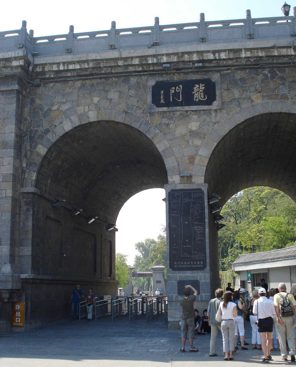
Longmen Grottoes in Luoyang
Photo: user:Kwz · source · CC BY-SA 3.0

At a glance

Province-level region
Henan Province[1][2][3][4]
Administrative coverage
7 districts and 7 counties[1][2][3][4]
Time zone
China Standard Time (UTC+8)[1][2][3][4]
Population
7.081 million (End of 2024)[1][2][3][4]
Climate
Warm-temperate continental monsoon climate[1][2][3][4]
Map scope
Municipal boundary with 14 county-level units[1][2][3][4]

Understand Luoyang through connected urban, district, and county landscapes

Luoyang is best understood as a river-basin municipality where multiple capital-city layers, Longmen carving, Erlitou archaeology, temples, peony culture, modern industry, and mountain counties coexist rather than form a single ancient-city narrative.

Luo River basin, Yi River and Longmen gorge, Loess hills and southern mountains, Seven districts and seven counties explain why the municipality cannot be reduced to its best-known attraction.

The guide connects documented history, living culture, food systems, work, landmarks, and three field routes without treating residents as a single type.

District and county conditions vary. Current weather, access rules, conservation requirements, and local guidance should be checked before travel.

Land and water

Luoyang's land and water systems explain settlement, access, work, and the differences between its urban core and outer county-level units.

Historical layers

Successive historical layers remain legible in Luoyang's sites, collections, routes, neighborhoods, and present-day municipal form.

Living culture and work

Living culture in Luoyang is presented through specific skills, institutions, workplaces, food systems, and community choices.

County-level differences

Luoyang's districts and counties have different landscapes, industries, memories, and daily rhythms; the city profile keeps those differences visible.

Location, boundary, and 3D buildings

The interactive map covers all 14 county-level units, including Laocheng District, Xigong District, Chanhe Hui District, Jianxi District.[1][2][3][4]

Loading city geometry…
County boundaries: © OpenStreetMap contributors · ODbL

Geography and the shape of the city

Four spatial relationships define Luoyang.

Luo River basin

In Luoyang, Luo River basin must be read together with Yi River and Longmen gorge and Loess hills and southern mountains. Their relationship distinguishes the central urban area from the municipality's district- and county-level landscapes.[1][2][3][4]

Yi River and Longmen gorge

In Luoyang, Yi River and Longmen gorge must be read together with Loess hills and southern mountains and Seven districts and seven counties. Their relationship distinguishes the central urban area from the municipality's district- and county-level landscapes.[1][2][3][4]

Loess hills and southern mountains

In Luoyang, Loess hills and southern mountains must be read together with Seven districts and seven counties and Luo River basin. Their relationship distinguishes the central urban area from the municipality's district- and county-level landscapes.[1][2][3][4]

Seven districts and seven counties

In Luoyang, Seven districts and seven counties must be read together with Luo River basin and Yi River and Longmen gorge. Their relationship distinguishes the central urban area from the municipality's district- and county-level landscapes.[1][2][3][4]

Weather now

Loading current conditions…

Forecast data: Open-Meteo

Population

7.081 million

Permanent residents across Luoyang Municipality

Population figures use the administrative area and source date shown below.[1][2][3][4]

Climate

Warm-temperate continental monsoon climate

Hot rainy summers, cold dry winters, spring winds, and sharp mountain–basin differences shape the Luo and Yi river plains and southern counties.

Climate describes long-term seasonal patterns; live conditions appear separately.[1][2][3][4]

Seasonal patterns

March–May

Spring

Spring in Luoyang can change quickly; rain, wind, pollen, fog, or elevation should be checked before long outdoor routes.[1][2][3][4]

June–August

Summer

Hot rainy summers, cold dry winters, spring winds, and sharp mountain–basin differences shape the Luo and Yi river plains and southern counties.[1][2][3][4]

September–November

Autumn

Autumn often provides clearer intervals and cooler evenings, but current forecasts still matter for coast, mountain, river, and county routes.[1][2][3][4]

December–February

Winter

Winter conditions vary across the municipality; layered clothing and paired indoor–outdoor routes are the safest general approach.[1][2][3][4]

A short history of the city

Five time layers connect surviving places with current urban and county form.

  1. Erlitou urban archaeology

    Erlitou urban archaeology places Bronze Age within Luoyang's longer sequence from Erlitou urban archaeology to Archaeology, industry, and urban expansion. Surviving sites, collections, routes, and urban form provide the evidence used in this guide.[1][2][3][4]

  2. Capital-city layers and regional routes

    Capital-city layers and regional routes places Eastern Zhou–Han eras within Luoyang's longer sequence from Erlitou urban archaeology to Archaeology, industry, and urban expansion. Surviving sites, collections, routes, and urban form provide the evidence used in this guide.[1][2][3][4]

  3. Longmen carving and cosmopolitan institutions

    Longmen carving and cosmopolitan institutions places Northern Wei–Tang eras within Luoyang's longer sequence from Erlitou urban archaeology to Archaeology, industry, and urban expansion. Surviving sites, collections, routes, and urban form provide the evidence used in this guide.[1][2][3][4]

  4. County markets, temples, and craft

    County markets, temples, and craft places Later imperial eras within Luoyang's longer sequence from Erlitou urban archaeology to Archaeology, industry, and urban expansion. Surviving sites, collections, routes, and urban form provide the evidence used in this guide.[1][2][3][4]

  5. Archaeology, industry, and urban expansion

    Archaeology, industry, and urban expansion places Contemporary within Luoyang's longer sequence from Erlitou urban archaeology to Archaeology, industry, and urban expansion. Surviving sites, collections, routes, and urban form provide the evidence used in this guide.[1][2][3][4]

People, language, and everyday rhythms

Residents are described through language, work, mobility, neighborhood, and present-day choice—not fixed personality labels.

Luoyang local speech and Standard Mandarin

Language use in Luoyang varies by family, generation, neighborhood, school, workplace, and migration history; local speech and Standard Mandarin are not interchangeable identity labels.[1][2][3][4]

Urban, district-town, county-town, and village rhythms

Luoyang's central neighborhoods, district towns, county seats, and villages differ in density, access, employment, services, and daily schedules.[1][2][3][4]

Work, study, migration, family, and tourism networks

Residents connect Luoyang to other places through work, study, migration, family, trade, and tourism; these networks change how neighborhoods and county communities function.[1][2][3][4]

Community-specific and changing identities

No single personality represents Luoyang. Age, occupation, language, gender, neighborhood, county background, and individual preference produce different and changing experiences.[1][2][3][4]

Culture and daily life

Longmen stone-carving interpretation

Longmen stone-carving interpretation is documented alongside Peony cultivation and festival and Capital-city archaeology. Together they show how practice is carried by named institutions, practitioners, neighborhoods, and county communities rather than by a single citywide stereotype.[1][2][3][4]

Peony cultivation and festival

Peony cultivation and festival is documented alongside Capital-city archaeology and Temple stewardship. Together they show how practice is carried by named institutions, practitioners, neighborhoods, and county communities rather than by a single citywide stereotype.[1][2][3][4]

Capital-city archaeology

Capital-city archaeology is documented alongside Temple stewardship and Heluo performance traditions. Together they show how practice is carried by named institutions, practitioners, neighborhoods, and county communities rather than by a single citywide stereotype.[1][2][3][4]

Temple stewardship

Temple stewardship is documented alongside Heluo performance traditions and Industrial neighborhood memory. Together they show how practice is carried by named institutions, practitioners, neighborhoods, and county communities rather than by a single citywide stereotype.[1][2][3][4]

Heluo performance traditions

Heluo performance traditions is documented alongside Industrial neighborhood memory and Longmen stone-carving interpretation. Together they show how practice is carried by named institutions, practitioners, neighborhoods, and county communities rather than by a single citywide stereotype.[1][2][3][4]

Industrial neighborhood memory

Industrial neighborhood memory is documented alongside Longmen stone-carving interpretation and Peony cultivation and festival. Together they show how practice is carried by named institutions, practitioners, neighborhoods, and county communities rather than by a single citywide stereotype.[1][2][3][4]

Food and local flavor

Six locally specific food records connect ingredients, work, markets, and social routines.

Luoyang water banquet is treated as one named Luoyang foodway. Ingredients, technique, season, maker, and district or county provenance should be verified instead of inferred from the dish name alone.

Luoyang water banquet

[1][2][3][4]

Beef soup is treated as one named Luoyang foodway. Ingredients, technique, season, maker, and district or county provenance should be verified instead of inferred from the dish name alone.

Beef soup

[1][2][3][4]

Donkey-meat soup traditions is treated as one named Luoyang foodway. Ingredients, technique, season, maker, and district or county provenance should be verified instead of inferred from the dish name alone.

Donkey-meat soup traditions

[1][2][3][4]

Peony-themed foods is treated as one named Luoyang foodway. Ingredients, technique, season, maker, and district or county provenance should be verified instead of inferred from the dish name alone.

Peony-themed foods

[1][2][3][4]

Luanchuan tofu is treated as one named Luoyang foodway. Ingredients, technique, season, maker, and district or county provenance should be verified instead of inferred from the dish name alone.

Luanchuan tofu

[1][2][3][4]

County wheat dishes is treated as one named Luoyang foodway. Ingredients, technique, season, maker, and district or county provenance should be verified instead of inferred from the dish name alone.

County wheat dishes

[1][2][3][4]

Landmarks and architecture

Longmen Grottoes

Longmen Grottoes provides one physical entry point into Luoyang. Its fabric, date, use, conservation status, and current access should be read separately and in relation to Luoyang Museum.[1][2][3][4]

Luoyang Museum

Luoyang Museum provides one physical entry point into Luoyang. Its fabric, date, use, conservation status, and current access should be read separately and in relation to White Horse Temple.[1][2][3][4]

White Horse Temple

White Horse Temple provides one physical entry point into Luoyang. Its fabric, date, use, conservation status, and current access should be read separately and in relation to Dingding Gate site.[1][2][3][4]

Dingding Gate site

Dingding Gate site provides one physical entry point into Luoyang. Its fabric, date, use, conservation status, and current access should be read separately and in relation to Erlitou Site Museum.[1][2][3][4]

Erlitou Site Museum

Erlitou Site Museum provides one physical entry point into Luoyang. Its fabric, date, use, conservation status, and current access should be read separately and in relation to Luanchuan mountain landscape.[1][2][3][4]

Luanchuan mountain landscape

Luanchuan mountain landscape provides one physical entry point into Luoyang. Its fabric, date, use, conservation status, and current access should be read separately and in relation to Longmen Grottoes.[1][2][3][4]

Ways to explore the city

Three field routes pair the core city with contrasting district or county landscapes.

Field route

Luoyang Museum → Dingding Gate → old city context

Luoyang Museum → Dingding Gate → old city context is a field sequence for comparing Luoyang's built form, landscape, work, and district or county context. Check current opening hours, weather, transport, safety, and conservation rules before departure.[1][2][3][4]

Field route

Longmen Grottoes → Yi River → southern county route

Longmen Grottoes → Yi River → southern county route is a field sequence for comparing Luoyang's built form, landscape, work, and district or county context. Check current opening hours, weather, transport, safety, and conservation rules before departure.[1][2][3][4]

Field route

Erlitou museum → Yanshi plain → White Horse Temple

Erlitou museum → Yanshi plain → White Horse Temple is a field sequence for comparing Luoyang's built form, landscape, work, and district or county context. Check current opening hours, weather, transport, safety, and conservation rules before departure.[1][2][3][4]

Continue with a local story

Documentary image for a local story about Luoyang
Photo: user:Kwz · source · CC BY-SA 3.0
Featured story

How can one city contain many different capital-city layers?

Changing river courses, dynastic planning, archaeology, reuse, destruction, ritual, and modern construction left overlapping centers instead of one preserved capital.

Read the story

Sources and review

Last content update
Image verificationImage rights and place accuracy are approved.
Map verificationMap license, version, and administrative code are verified.

Numbered reference sources

  1. Luoyang Municipal Government — city overview and public information
  2. Luoyang — reviewed 2024 population and statistical reference
  3. Ministry of Civil Affairs — Luoyang county-level divisions
  4. China Meteorological Administration — climate and weather reference
Report a correction