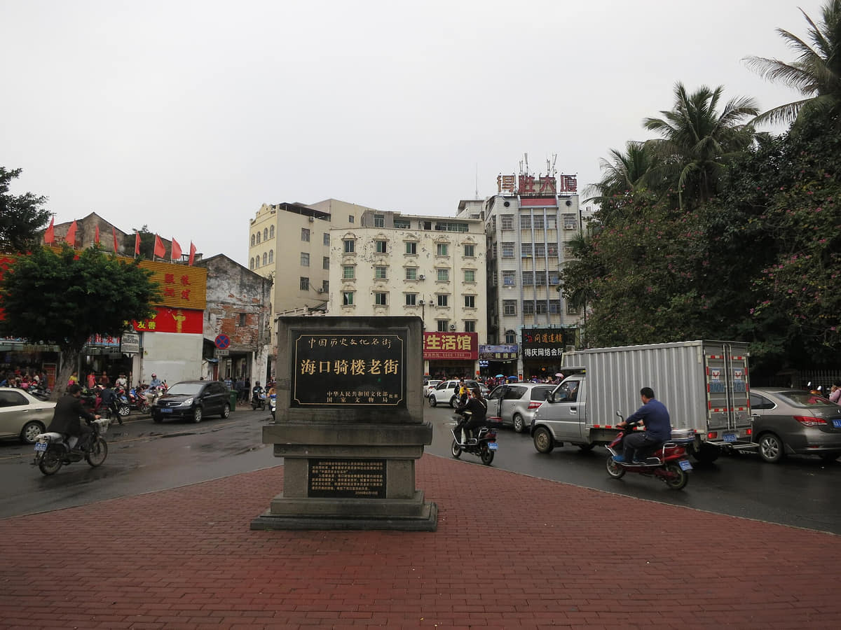
Haikou, China, is Hainan's tropical capital and a four-district municipality where Qilou streets, volcanic ground, the Nandu River, mangrove estuaries, ports, markets and typhoon adaptation meet.
Qilou arcades, tropical coast, volcanic landscapes, mangroves, Hainan Museum, island transport gateway, rice noodles, markets, and overseas Hainanese connections[1][2][3][4]
Guide scope
Four districts spanning the coastal core, Haidian Island, airport corridor, eastern mangroves, western volcanic villages, ports, farms, towns, and southern rural landscapes[1][2][3][4]
Understand Haikou through Hainan's capital, volcanic ground and tropical coast
Haikou is a four-district tropical municipality whose environmental range is unusually compressed: volcanic ground and basalt villages in the west, a bay and river-mouth city along the north coast, the Nandu River through the east, and the tidal mangroves of Dongzhai Harbour. Xiuying, Longhua, Qiongshan and Meilan belong to one municipality but do not share one landscape, density or daily rhythm.
The city's history is best read through two old centres and their connections. Fucheng preserves an administrative, educational and commemorative landscape; the Qilou and old-port area records maritime trade, overseas Hainanese networks, customs, warehouses, shops and climate-adapted arcades. Wugong Ci, Hai Rui Tomb, Xiuying Fort and Old Qiong Customs are protected places with different dates and functions—not one undifferentiated old town.
Living culture is specific to practitioners and places. Qiong opera, Zhai opera, Hainan Bayin, Sanjiang puppet theatre, coconut carving, Madam Xian belief, Junpo and Fucheng's Lantern Festival have different safeguarding units, communities and calendars. A costume, memorial hall, festival programme, museum room or tourist performance cannot stand for every resident or every island tradition.
Haikou is warm and humid year-round, with strong tropical sun, a concentrated rainy season and exposure to tropical cyclones, heavy rain, high wind, storm surge, urban flooding and coastal hazards. Weather, tide, river level, swimming safety, transport, venue access, crowding and food safety are live conditions. This guide explains durable context; current decisions require official forecasts, reserve rules and operator notices.
Quick answers
Where is Haikou, China?
Haikou is the capital of Hainan Province on the north coast of Hainan Island, facing the Qiongzhou Strait. Its four districts span the central city, volcanic landscapes, the Nandu River, wetlands, ports and coast.
What is Haikou known for?
Haikou is known for Qilou arcades, tropical weather, volcanic landscapes, mangroves, island and maritime migration, morning tea and Hainan food, and its role as the province's transport and institutional capital.
Volcanic coast
Lava landscapes, tropical shore, river mouths, mangroves, and storms explain the municipality's environmental range.
Maritime migration
Qilou, family networks, trade, language, food, remittances, and return journeys link island and overseas histories.
Island gateway
Port, ferry, airport, administration, hospitals, universities, services, and markets connect Haikou to all Hainan.
Tropical resilience
Heat, humidity, typhoons, drainage, mangroves, building shade, coastal exposure, and public alerts shape daily adaptation.
A visual record of the city
Twenty-seven locally hosted, rights-cleared images build Haikou across four districts: Qilou commerce, Fucheng memorial places and protected port heritage; visible basalt lava, the Nandu River, Dongzhai mangroves, Haikou Bay and the west coast; Qiong opera, a Madam Xian memorial and one carefully bounded 2012 workshop scene; provincial museum, university, library, airport and rail institutions; and seven breakfast, market or regional-food references. Captions separate visible form from provenance, reconstruction, living practice and live conditions.
Packaged coconut sugarPhoto: François Nguyen · source · CC BY 2.0
Location, boundary, and 3D buildings
The core faces Haikou Bay and spans river mouths and coastal islands; the municipality extends west across volcanic terrain, east to airport and mangrove estuaries, and south through farms, towns, reservoirs, and villages.[1][2][3][4]
Volcanic terraces, tropical coast, river mouths, mangrove estuaries, islands, and a four-district municipality define Haikou.
Volcanic terrace
Basalt, old craters, lava formations, fertile soils, villages, reservoirs, and agricultural land shape the western municipality.[1][2][3][4]
Tropical coast
Haikou Bay, river mouths, beaches, reefs, reclaimed edges, ports, tidal systems, and storm exposure define the north.[1][2][3][4]
Mangrove estuaries
Dongzhai Harbour and eastern wetlands link tides, mudflats, fisheries, birds, mangrove ecology, villages, and conservation.[1][2][3][4]
Municipal scale
Four districts span the coastal core, Haidian Island, airport and eastern wetlands, volcanic villages, ports, farms, towns, and southern rural landscapes.[1][2][3][4]
Permanent residents across all four districts of Haikou Municipality—Xiuying, Longhua, Qiongshan and Meilan; do not mix with the central built-up area, registered residents, airport, rail or ferry passengers, students, seasonal residents, visitors, tourists, or a wider Haikou economic circle
Population figures use the administrative area and source date shown below.[5][6]
Climate
Tropical maritime monsoon climate
Conditions are warm and humid year-round, with a pronounced wet season, strong tropical sun, and typhoon, storm-surge, wind, and heavy-rain risk from summer into autumn.
Climate describes long-term seasonal patterns; live conditions appear separately.[6][16][32]
Seasonal patterns
November–April
Dry season
Milder temperatures, lower rainfall, trade winds, and occasional cool damp spells generally favor walking and cross-island exploration.[1][2][3][4]
May–June
Early wet season
Heat and humidity rise quickly; thunderstorms and heavy rain require shade, hydration, drainage awareness, and flexible plans.[1][2][3][4]
July–October
Typhoon season
Tropical cyclones, storm surge, strong wind, heavy rain, waves, and closures can disrupt coast, ferries, parks, and flights.[1][2][3][4]
Tropical sun and humidity remain important even in cooler months; UV, insects, salt air, and sudden showers affect outdoor use.
Eleven sourced layers move from volcanic and tidal foundations through river-and-strait settlement, Fucheng, Wugong Ci, port trade, overseas-Hainanese Qilou, customs, coastal defence, transport and public institutions, multi-centre growth, and the exact end-2024 four-district municipality.
Quaternary volcanism, basaltic lava, red soils, rivers, bays, reefs, tidal flats and mangroves shaped water, farming, settlement and movement long before a modern municipality. The UNESCO geopark spans Haikou and Zhanjiang, so park-wide facts must not be assigned wholly to Haikou.[14][16]
Long-duration island networks
The Nandu River, northern landing places, agricultural ground, fishing waters and routes into inland Hainan supported settlements and exchange over long periods. Archaeological objects displayed at Hainan Museum need catalogue provenance before they can be called Haikou finds.[17][16]
Historic urban centre
Fucheng's streets, gates, educational places, temples, residences and memorial sites record changing administrative and social functions. The protected district includes living lanes and later alterations, not a frozen plan from one dynasty.[8]
Historical memory
Wugong Ci brings architecture, gardens, inscriptions and later commemoration into one complex associated with officials exiled to Hainan and other historical figures. Individual buildings and stele corridors have distinct construction and repair histories.[11][12]
Maritime urban formation
Landing places, shipping, markets, warehouses, customs work and roads connected Haikou to Hainan's interior, the Qiongzhou Strait and wider maritime routes. Port history is made of institutions and labour as well as façades.[8][10]
Nineteenth to early twentieth centuries
Overseas family and business networks, imported architectural ideas, local builders, tropical rain and sun, shop-house commerce and changing materials contributed to the arcaded district. No single façade proves a precise origin or influence without a building record.[9][8]
Modern port institutions
Old Qiong Customs, the riverfront clock tower and nearby commercial streets help trace changing systems of time, taxation, shipping and urban administration. Protected buildings, rebuilt landmarks and present adaptive-use projects must remain distinct.[10][8]
Late-Qing military landscape
Xiuying Fort records one phase of coastal-defence construction on the northern shore. Surviving artillery, earthworks, later military use, repair and visitor interpretation require site-specific documentation rather than a heroic or nationalistic shorthand.[11]
Twentieth-century transformation
Roads, ferry and port infrastructure, schools, hospitals, markets, housing, aviation and new public institutions expanded the coastal city and connected it more strongly to the island. Dates and administrative stages should be sourced separately rather than compressed into one founding moment.[6][7]
Since the late twentieth century
Administrative, education, service, logistics, airport, rail, port and coastal-development functions produced multiple centres across Longhua, Qiongshan, Meilan and Xiuying. The central skyline is only one municipal section.[6][31][30]
End of 2024
Haikou had 3.0314 million permanent residents at end-2024 across four districts. This municipal figure must not be mixed with the central built-up area, registered residents, airport or ferry passengers, students, seasonal visitors, tourists or a wider Haikou economic circle.[5][6]
People, language, and everyday rhythms
Eight perspectives describe 3.0314 million end-2024 permanent residents across four districts, distinguishing urban, island, port, airport, volcanic-village, farm and wetland settings while rejecting one language, migration story or tropical personality.
3.0314 million people, not one urban core
The end-2024 permanent-resident count covers Xiuying, Longhua, Qiongshan and Meilan, including dense neighbourhoods, islands, towns, farms, volcanic villages, airport communities and wetland edges.[5][6]
Four districts have different daily geographies
Old commercial streets, Fucheng lanes, Haidian Island campuses, port and west-coast districts, volcanic settlements, eastern airport corridors and mangrove villages produce different travel, work and housing patterns.[8][16][14]
Long-established and mobile residents
Hainanese families, people from other island cities and counties, mainland migrants, students, service workers, traders and return migrants carry different biographies and degrees of local attachment.[5][31]
Languages follow families and situations
Standard Mandarin is widely used, while Hainanese varieties and other languages circulate through families, neighbourhoods, markets, performance and migration networks. Speech cannot be predicted from appearance or district alone.[18][19]
Overseas links are personal, not universal
Some families maintain histories of migration, business, remittance and return across Southeast Asia and beyond. Qilou heritage makes these links visible, but not every resident has an overseas-Hainanese biography.[8][9]
Work connects island and city
Port, airport, rail, logistics, administration, education, health, hospitality, retail, food markets, construction, farming, fishing and conservation support very different workdays.[6][30]
Heat, rain and storms shape routines
Arcades, shade, rain cover, drainage, morning and evening schedules, food storage, coastal warnings and storm preparation are practical adaptations—not evidence that everyone is relaxed or lives outdoors.[6][26][32]
No single Haikou personality
Tropical, leisurely, hospitable, maritime or open may describe selected narratives and spaces. They are interpretations, not measurable traits shared by more than three million people.[5][7]
A safeguarded theatre system using Hainanese speech, vocal styles, instruments, movement, scripts, troupes and audiences. One costume or tourist show cannot represent its full repertoire or transmission.[18]
Hainan Zhai opera
A ritual-theatre tradition with its own performance history and documented relationship to the development of Qiong opera. It should not be collapsed into Qiong opera or treated as an unchanged ancient survival.[19]
Hainan Bayin instrumental music
An ensemble practice safeguarded in Meilan with varied strings, winds and percussion. Instrument lists, repertoire, players, ceremonial setting and amplification vary by group and event.[20]
Sanjiang Gongzai puppet theatre
A place-specific puppet-theatre tradition in Sanjiang whose carved heads, roles, manipulation, music, stories, performers and audiences form one living system.[21]
Hainan coconut carving
A protected craft using coconut shell, wood and fibre in varied objects. Sale in Haikou does not prove Haikou manufacture, a named practitioner or traditional method without provenance.[22]
Madam Xian belief and Junpo
A community-organised memorial and ritual practice with specific villages, organisers, temples, processions and calendars. A memorial hall is a place record, not a live-ritual image.[23]
Fucheng Lantern Festival flower exchange
A living festival context combining flower exchange, lanterns, street gathering and additional performances. Origins, meanings and programme details should be attributed, and the current route checked annually.[24]
Qilou as lived urban culture
Shade, rain cover, shop-houses, worship spaces, groceries, snacks, workshops, residents, tourism and repair share limited streets. Heritage value depends on daily use as well as façades.[9][8]
Museum interpretation and provenance
Hainan Museum provides island-wide context from a building in Haikou. Collection labels, excavation records and source communities—not the museum address—determine an object's provenance and meaning.[17]
One 2012 blanket-making workshop
The documented thread-and-batting process enriches the city's labour history, but remains a single dated scene. It is not labelled intangible heritage and should not be romanticised as a universal tradition.[33]
Maritime migration in everyday forms
Architecture, family stories, food, coffee and tea habits, business networks, language and return journeys show movement across the sea. Similarity to Southeast Asian forms does not prove one direct origin.[8][27]
Contemporary coastal public culture
Wormhole Library, parks, beaches, universities, exhibitions, music, sport and new coastal buildings diversify public life. Programmes, access and audience remain current and institution-specific.[29][31]
Food and local flavor
Fourteen entries treat Haikou food as a system of rice-noodle production, morning shops, laobacha, chilled desserts, coconut products, fish logistics, lane snacks, night markets and island-wide circulation. Every image-backed dish states whether it was photographed in Haikou, elsewhere in Hainan or overseas, and keeps recipe, provenance, allergen and current-safety limits explicit.
Image credits and licenses
Breakfast noodles in HaikouPhoto: Anna Frodesiak · source · CC0
Wholesale market at Haikou New PortPhoto: Anna Frodesiak · source · CC0
Named local cooking practice
Haikou Hainan rice noodles
Fine rice noodles, sauces or broth, peanuts, sesame, meat, dried seafood, pickles, bamboo shoots and aromatics appear in varied combinations. Heritage recognition does not make every bowl identical.[25][28]
Markets and morning shops
Breakfast-noodle ecology
Hainanfen, soup noodles and other rice-noodle forms depend on milling, fresh distribution, broth, toppings, market schedules and neighbourhood demand. A photographed bowl identifies only one serving.[25][27]
Tea-house social meal
Laobacha
Tea or coffee, sweet buns, savoury pastries, noodles and other small dishes can support long conversations and flexible meal times. Menus, sugar, fats, allergens, hygiene and crowd conditions vary by venue.[26]
Chilled mixed dessert family
Qingbuliang
Coconut milk or other liquids, ice, beans, grains, fruit, jellies and nuts create many versions. The photographed Sanya bowl is a regional visual reference, not a Haikou standard.[27]
Island-wide circulating dish
Coconut chicken
Fresh coconut water, chicken and dipping sauces form a widely circulated contemporary dish family. The Singapore photograph demonstrates diaspora circulation, not Haikou origin or endorsement.[27][28]
Regional household food
Yi bua and wrapped rice cakes
Glutinous wrappers, coconut, peanut, sesame, sugar or other fillings and leaves vary by maker and locality. Name, festival association and freshness should be confirmed directly.[27][25]
Ingredient and product system
Coconut sugar and coconut products
Water, milk, flesh, oil, shell, fibre and sugar enter drinks, sweets, soups, crafts and packaged goods. A product labelled Hainan is not automatically made in Haikou.[22][28]
Coastal food infrastructure
Fish markets and cold-chain labour
Landing, wholesale, ice, boxes, vehicles, market timing and restaurant distribution connect sea and table. Species, catch origin, legality, refrigeration and price need current verification.[6][27]
Old-city morning flavours
Pepper soups and lane breakfasts
Pork, offal or other meats, pickles, broth and Hainan pepper can form warming soups around Qilou lanes. Ingredients and names vary, so visitors should not infer meat type from an English nickname.[27]
Tropical produce as street food
Pickled fruit and sour snacks
Mango, papaya and other produce may be combined with salt, sugar, vinegar, chili or yellow-lantern chili. Preparation, refrigeration and utensil hygiene differ by stall.[27]
Late urban food
Night markets and student districts
Hainan University surroundings and other evening markets mix regional dishes, grilled seafood, fruit, desserts and migrant foods. Opening, stall list, crowding and payment are live.[27][31]
Regional circulation
An island-wide table in the capital
Wenchang chicken, zaopocu, Baoluo noodles and foods from many Hainan localities circulate through Haikou. Availability in the capital proves exchange, not municipal origin.[28][27]
A living historic district of arcades, shop-houses, lanes, worship spaces, food, residents, repair and tourism. Original fabric, reconstruction and adaptive use should be identified building by building.[9][8]
Fucheng historic district
An older administrative and residential centre with streets, educational places, temples, memorials and later urban layers that complement rather than duplicate the port-side Qilou district.[8]
Wugong Ci
A protected memorial complex of buildings, gardens, inscriptions and layered historical interpretation. Current repair work means individual spaces and access can change.[11][12]
Hai Rui Cultural Park
A tomb-and-memorial landscape where burial fabric, ceremonial approach, inscriptions, later park design, education and current programming remain distinct.[11][13]
Xiuying Fort
A protected late-Qing coastal-defence site. Its gate, artillery positions, surviving material, repair history and interpretation need to be read as separate evidence.[11]
Old Qiong Customs
A protected maritime-administration site near Deshengsha Road whose architecture, institutional history and current adaptive-use project connect the old port to modern conservation.[10]
Haikou Clock Tower
A riverfront orientation point associated with the old commercial waterfront. Present structure, rebuilding, lighting and public access should not be compressed into one original date.[8][10]
Hainan Museum
The province-wide collecting, research and exhibition institution located in Qiongshan. It provides island context while retaining the separate provenance of every object.[17]
Haikou Volcanic Cluster
The Haikou section of Leiqiong UNESCO Global Geopark makes basaltic lava, cones, craters, tunnels, soils, villages and agricultural adaptation legible through managed sites.[14]
Dongzhai Harbour
A protected tidal mangrove system of forest, mudflat, channels, birds, fisheries, restoration, monitoring and nearby communities. Reserve rules take priority over sightseeing plans.[15][16]
Nandu River
A major river orientation system joining inland Hainan, farms, settlements, bridges, wetlands and the eastern coastal plain. Water and access conditions vary by reach and season.[6][16]
Century Bridge and Haikou Bay
Bridge, river mouth, Haidian Island, tidal shore, parks, reclaimed land and skyline form a readable metropolitan cross-section, while traffic and coastal conditions remain live.[6][16]
Evergreen Park
A large reclaimed bayfront public landscape useful for reading shoreline engineering, planting, leisure and skyline growth over time. A historic panorama is not a current site map.[16]
Holiday Beach and the west coast
A public coastal landscape of sand, palms, swimming water and an expanding skyline. Same-day weather, water quality, surf and lifeguard information govern safe use.[32][7]
Wormhole Library
A contemporary coastal reading and cultural building whose architecture is durable while collections, reservations, programmes and opening conditions change.[29]
Meilan Airport and Haikou East Station
Air and island-rail gateways that make Haikou a transfer city. Buildings are durable; routes, schedules, security, queues and accessible transfers are operator-controlled.[30][6]
Hainan University Haidian campus
A major education and research landscape on Haidian Island. The campus connects students and knowledge from across Hainan and beyond, while access and programmes remain institutional.[31]
Ways to explore the city
Pair the qilu coast with a volcanic landscape and a mangrove estuary to understand the municipality's full environmental and cultural range.
Maritime old city
Qilou streets → market breakfast → Haikou Bay
Connect arcade architecture, migration, commerce, food, river mouth, bridge, coastline, and contemporary public space.[1][2][3][4]
Lava to city
Leiqiong Geopark → volcanic village → central museum
Move from geology and agricultural adaptation to collections that place the volcanic north inside an island-wide history.[1][2][3][4]
Tidal edge
Dongzhai Harbour → eastern villages → airport or urban core
Read tides, mangroves, fisheries, conservation, storms, livelihoods, infrastructure, and metropolitan links as one system.[1][2][3][4]