
Land and water
Datong's land and water systems explain settlement, access, work, and the differences between its urban core and outer county-level units.
Shanxi Province · Shanxi Province, China
Datong is a northern plateau city where frontier routes, Yungang's cave temples, Liao–Jin architecture, county fortifications, coal and energy industries, reconstructed urban fabric, and mountain villages form a complex present.
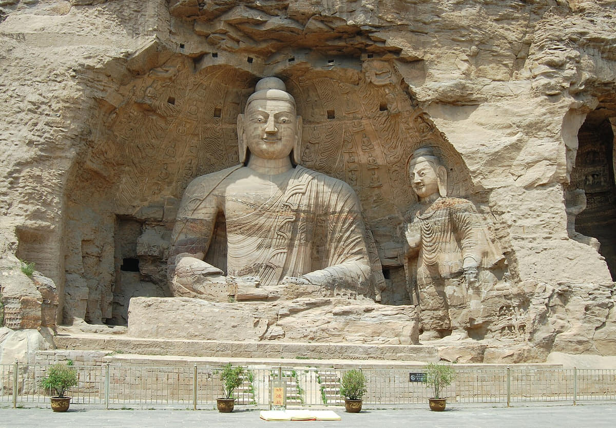
Datong is a northern plateau city where frontier routes, Yungang's cave temples, Liao–Jin architecture, county fortifications, coal and energy industries, reconstructed urban fabric, and mountain villages form a complex present.
Loess plateau and Datong basin, Sanggan River system, Northern mountain passes, Four districts and six counties explain why the municipality cannot be reduced to its best-known attraction.
The guide connects documented history, living culture, food systems, work, landmarks, and three field routes without treating residents as a single type.
District and county conditions vary. Current weather, access rules, conservation requirements, and local guidance should be checked before travel.
Datong's land and water systems explain settlement, access, work, and the differences between its urban core and outer county-level units.
Successive historical layers remain legible in Datong's sites, collections, routes, neighborhoods, and present-day municipal form.
Living culture in Datong is presented through specific skills, institutions, workplaces, food systems, and community choices.
Datong's districts and counties have different landscapes, industries, memories, and daily rhythms; the city profile keeps those differences visible.
Six reviewed visual records for Datong.
The interactive map covers all 10 county-level units, including Xinrong District, Pingcheng District, Yungang District, Yunzhou District.[1][2][3][4]
Four spatial relationships define Datong.
In Datong, Loess plateau and Datong basin must be read together with Sanggan River system and Northern mountain passes. Their relationship distinguishes the central urban area from the municipality's district- and county-level landscapes.[1][2][3][4]
In Datong, Sanggan River system must be read together with Northern mountain passes and Four districts and six counties. Their relationship distinguishes the central urban area from the municipality's district- and county-level landscapes.[1][2][3][4]
In Datong, Northern mountain passes must be read together with Four districts and six counties and Loess plateau and Datong basin. Their relationship distinguishes the central urban area from the municipality's district- and county-level landscapes.[1][2][3][4]
In Datong, Four districts and six counties must be read together with Loess plateau and Datong basin and Sanggan River system. Their relationship distinguishes the central urban area from the municipality's district- and county-level landscapes.[1][2][3][4]
Loading current conditions…
Forecast data: Open-MeteoPermanent residents across Datong Municipality
Population figures use the administrative area and source date shown below.[1][2][3][4]Cold long winters, dry windy springs, warm short summers, large day–night ranges, and plateau exposure shape farming, buildings, and outdoor access.
Climate describes long-term seasonal patterns; live conditions appear separately.[1][2][3][4]Spring in Datong can change quickly; rain, wind, pollen, fog, or elevation should be checked before long outdoor routes.[1][2][3][4]
Cold long winters, dry windy springs, warm short summers, large day–night ranges, and plateau exposure shape farming, buildings, and outdoor access.[1][2][3][4]
Autumn often provides clearer intervals and cooler evenings, but current forecasts still matter for coast, mountain, river, and county routes.[1][2][3][4]
Winter conditions vary across the municipality; layered clothing and paired indoor–outdoor routes are the safest general approach.[1][2][3][4]
Five time layers connect surviving places with current urban and county form.
Plateau routes and fortified communities places Early frontier settlement within Datong's longer sequence from Plateau routes and fortified communities to Energy transition, reconstruction, and conservation. Surviving sites, collections, routes, and urban form provide the evidence used in this guide.[1][2][3][4]
Capital and Yungang cave construction places Northern Wei era within Datong's longer sequence from Plateau routes and fortified communities to Energy transition, reconstruction, and conservation. Surviving sites, collections, routes, and urban form provide the evidence used in this guide.[1][2][3][4]
Monumental timber architecture places Liao–Jin eras within Datong's longer sequence from Plateau routes and fortified communities to Energy transition, reconstruction, and conservation. Surviving sites, collections, routes, and urban form provide the evidence used in this guide.[1][2][3][4]
Coal industry and urban growth places 20th century within Datong's longer sequence from Plateau routes and fortified communities to Energy transition, reconstruction, and conservation. Surviving sites, collections, routes, and urban form provide the evidence used in this guide.[1][2][3][4]
Energy transition, reconstruction, and conservation places Contemporary within Datong's longer sequence from Plateau routes and fortified communities to Energy transition, reconstruction, and conservation. Surviving sites, collections, routes, and urban form provide the evidence used in this guide.[1][2][3][4]
Residents are described through language, work, mobility, neighborhood, and present-day choice—not fixed personality labels.
Language use in Datong varies by family, generation, neighborhood, school, workplace, and migration history; local speech and Standard Mandarin are not interchangeable identity labels.[1][2][3][4]
Datong's central neighborhoods, district towns, county seats, and villages differ in density, access, employment, services, and daily schedules.[1][2][3][4]
Residents connect Datong to other places through work, study, migration, family, trade, and tourism; these networks change how neighborhoods and county communities function.[1][2][3][4]
No single personality represents Datong. Age, occupation, language, gender, neighborhood, county background, and individual preference produce different and changing experiences.[1][2][3][4]
Six locally specific food records connect ingredients, work, markets, and social routines.
Three field routes pair the core city with contrasting district or county landscapes.
Yungang Grottoes → mining-landscape context → city museum is a field sequence for comparing Datong's built form, landscape, work, and district or county context. Check current opening hours, weather, transport, safety, and conservation rules before departure.[1][2][3][4]
Huayan Temple → Shanhua Temple → city-wall circuit is a field sequence for comparing Datong's built form, landscape, work, and district or county context. Check current opening hours, weather, transport, safety, and conservation rules before departure.[1][2][3][4]
Hunyuan county town → Hanging Temple → mountain-pass route is a field sequence for comparing Datong's built form, landscape, work, and district or county context. Check current opening hours, weather, transport, safety, and conservation rules before departure.[1][2][3][4]
Stone, plateau corridors, political centers, labor, coal, rail, conservation, and reconstruction each reorganized the city without erasing earlier layers.
Read the story