An irrigated oasis capital where Yellow River water, Helan Mountain archaeology, Xixia heritage, Hui and other communities, wetlands, agriculture, food, and desert-edge management form one connected system.
Yellow River irrigation oasis, Helan Mountains, Xixia Imperial Tombs, rock art, Hui community institutions, wetlands, mutton, agriculture, and desert-edge ecology[1][2][3][4]
Guide scope
Six county-level units spanning the old and new city, irrigation canals, Yellow River wetlands, farms, Helan foothills, Lingwu, industrial areas, county towns, and villages[1][2][3][4]
Understand Yinchuan as a managed oasis between mountain and desert
Yinchuan occupies a Yellow River irrigation plain between the Helan Mountains and eastern sandy lands. Canals, wetlands, farms, shelterbelts, villages, and urban water systems make settlement possible in a dry climate.
Ningxia Museum, Xixia Imperial Tombs, rock art, mosques, temples, markets, old streets, new districts, vineyards, food production, and Lingwu reveal historical and contemporary layers far beyond a simple desert-city image.
Yinchuan is an engineered oasis between the Helan Mountains, Yellow River and eastern sandy lands. Canals, drains, wetlands, fields, shelterbelts, vineyards, villages and urban supply systems are part of the same water landscape.
The municipality spans the old Xingqing core, newer Jinfeng and Xixia districts, Helan foothills, Yongning and Helan counties, and Lingwu. Archaeology, living communities, farming and industry must not be compressed into a desert-city image.
Irrigated oasis
Yellow River water, canals, wetlands, farms, towns, soil, and ecological management explain settlement.
Mountain–desert boundary
Helan Mountains and eastern sandy lands frame water, wind, ecology, archaeology, agriculture, and city growth.
Xixia material world
Tombs, writing, architecture, art, religion, museum collections, research, and conservation reveal a major historical layer.
Living community institutions
Mosques, markets, schools, homes, food businesses, work, and public services keep cultural life contemporary and specific.
A visual record of the city
Eighteen locally hosted, rights-cleared images cover the central city, outer municipal areas, institutions, transport, daily space and food context. Captions distinguish city evidence from regional references and live conditions.
The core sits on a canal-fed plain; the municipality extends west to the Helan foothills, east toward the Yellow River and sandy lands, and through wetlands, farms, vineyards, towns, industry, and Lingwu.[1][2][3][4]
Yellow River canals, an oasis plain, wetlands, Helan Mountains, desert-edge ecology, and six county-level units define Yinchuan.
Yellow River irrigation plain
Canals and river water support an oasis of farms, wetlands, towns, and dense settlement within an otherwise dry region.[1][2][3][4]
Helan Mountain edge
The mountains west of the city influence water, wind, ecology, archaeology, views, vineyards, mining legacies, and settlement limits.[1][2][3][4]
Desert boundary
The Ordos and sandy lands east of the river make shelterbelts, wetlands, irrigation efficiency, soil salinity, and ecological management important.[1][2][3][4]
Six units
Three districts, two counties, and Lingwu span the urban oasis, farms, river channels, wetlands, mountain edge, industrial areas, towns, and villages.[1][2][3][4]
Population figures use the administrative area and source date shown below.[1][2][3][4]
Climate
Temperate arid to semi-arid continental climate
Conditions are dry and sunny with hot summers, cold winters, large day–night temperature ranges, windy and dusty springs, and limited rainfall concentrated in warmer months.
Climate describes long-term seasonal patterns; live conditions appear separately.[1][2][3][4]
Seasonal patterns
March–May
Spring
Wind, dust, dry air, rapid warming, and strong sun require layers, hydration, and air-quality checks.[1][2][3][4]
June–August
Summer
Hot dry days, intense sun, cooler nights, thunderstorms, and irrigation landscapes favor shade and water planning.[1][2][3][4]
September–November
Autumn
Clear skies, harvest landscapes, cool nights, and fast seasonal change suit mountain-edge and wetland routes.[1][2][3][4]
December–February
Winter
Cold dry air, freezing nights, wind, ice, and short daylight make warm layers and current conditions important.[1][2][3][4]
A short history of the city
Rock art, Xixia heritage, irrigation, walled-city and community institutions, transport, industry, and contemporary ecological management form distinct layers.
Rock art, archaeology, farming, herding, river crossings, and routes document long human use of the region.[1][2][3][4]
Regional capital landscape
Imperial tombs, architecture, writing, religion, agriculture, craft, and trade preserve a major medieval layer.[1][2][3][4]
Irrigation and walled city
Canals, farming, military administration, markets, mosques, temples, migration, and river management shaped the oasis center.[1][2][3][4]
Transport and regional institutions
Roads, rail, public institutions, industry, housing, education, and migration expanded the city across the plain.[1][2][3][4]
Oasis metropolis
New districts, services, industry, wine production, tourism, wetland restoration, transport, and ecological management reshape the municipality.[1][2][3][4]
Helan rock art and settlement
Petroglyphs and archaeological sites record long human activity, but motif dates, meanings and communities require object-level scholarship.[1][2][3][4]
Xixia imperial landscape
Tombs, architecture, inscriptions and objects form a protected archaeological landscape; museum display and excavation provenance must remain distinct.[1][2][3][4]
Walled city, irrigation and institutions
Canals, agriculture, city walls, pagodas, mosques, temples, markets and community life reshaped the oasis over multiple periods.[1][2][3][4]
Oasis metropolitan growth
New districts, rail, industry, vineyards, wetland projects, water management and ecological restoration extend the city across the plain.[1][2][3][4]
People, language, and everyday rhythms
Residents include Hui, Han, Mongol, Manchu and other communities, old and new urban households, farmers, industrial and service workers, students, traders, county residents, and migrants.
Languages
Standard Mandarin and local Lanzhou–Yinchuan Mandarin are widely used, with other languages present in families and communities.[1][2][3][4]
Hui and other communities
Hui, Han, Mongol, Manchu and other residents have varied neighborhoods, occupations, institutions, histories, and present-day identities.[1][2][3][4]
Oasis livelihoods
Urban services, public institutions, manufacturing, logistics, farming, vineyards, food production, county towns, and tourism support different routines.[1][2][3][4]
Avoiding stereotypes
Religious identity, mutton, desert scenery, and Xixia heritage are visible, but residents differ by generation, language, work, district, migration, and personal choice.[1][2][3][4]
Multiple communities
Hui, Han, Mongol, Manchu and other residents live across old neighbourhoods, new districts, farms, county towns, industrial areas and villages.[1][2][3][4]
Community-specific practice
Religious observance, food rules, language, work and family histories vary. Architecture or dress never identifies an individual's beliefs.[1][2][3][4]
Culture and daily life
Image credits and licenses
Ningxia MuseumPhoto: Gary Lee Todd, Ph.D. · source · CC0
Archaeology, conservation, inscriptions, manuscripts, museum catalogues and new scholarship continually refine how the imperial landscape is understood.[1][2][3][4]
Canal knowledge and irrigation
Canal maintenance, farming calendars, water allocation, wetland work and village knowledge form living culture as much as monuments do.[1][2][3][4]
Religious and community institutions
Mosques, Buddhist sites, temples and community places must be presented with site-specific histories and current access rules.[1][2][3][4]
Contemporary oasis city
Museums, universities, music, sport, design, wine production, media and neighbourhood public life add changing forms of expression.[1][2][3][4]
Ingredient sourcing, preparation, restaurant practice, home traditions, migrant cuisines, and individual preference create a varied city food landscape.[1][2][3][4]
Shared meat dish
Mutton sharing and preparation
Cut, age, sourcing, halal practice, cooking, salt and serving style vary across households and restaurants.[1][2][3][4]
Breakfast and market bowl
Offal soup handling and variation
Offal selection, cleaning, broth, bread and seasoning vary; safe handling cannot be assessed from a photograph.[1][2][3][4]
Everyday wheat foods
Noodles and breads
Hand-pulled or cut noodles, flatbreads and filled dough reflect household, market and community-specific practice.[1][2][3][4]
Irrigated agriculture
Yellow River rice
Rice grown on irrigated plains connects food to water allocation, soils and farm management; origin needs product-level labels.[1][2][3][4]
Ningxia regional product
Wolfberries
Fresh and dried berries circulate through Yinchuan, but farms may be elsewhere in Ningxia; grading, claims and processing vary.[1][2][3][4]
Helan foothill agriculture
Grapes and wine
Vineyards and wineries connect climate, irrigation, soil, labour and tourism; labels determine exact origin and producer.[1][2][3][4]
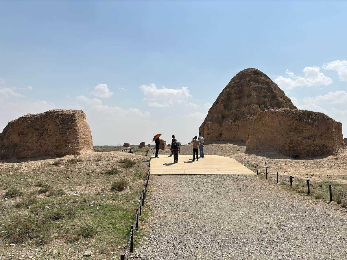
An archaeological landscape where earthen architecture, mountain backdrop, writing, ritual, research, conservation, and tourism meet.[1][2][3][4]
Ningxia Museum
A starting point for irrigation history, Xixia collections, rock art, communities, trade, ecology, research, and conservation.[1][2][3][4]
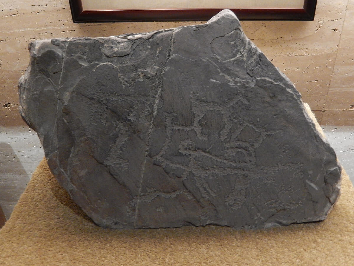
Helan Mountain rock art
A distributed cultural landscape requiring archaeological context, community histories, documentation, conservation, and careful site management.[1][2][3][4]
Drum Tower and old grid
The central landmark connects historic street patterns, markets, religious sites, rebuilding, commerce, traffic, and public memory.[1][2][3][4]
Haibao Pagoda
Religious architecture, water, temple grounds, restoration, worship, recreation, and city expansion overlap at the northern old-city edge.[1][2][3][4]
Yellow River wetlands
Channels, irrigation, farms, birds, fish ponds, parks, flood systems, restoration, and urban water use explain the oasis.[1][2][3][4]
Xixia tomb landscape
A large archaeological landscape whose tomb mounds, associated sites, museum, conservation zones and mountain setting require spatial context.[1][2][3][4]
Chengtian Temple Pagoda
The present pagoda reflects rebuilding after earlier destruction; foundation history and visible fabric are not the same date.[1][2][3][4]
Xixia Museum
An interpretation institution where displayed objects, replicas, models and excavation sites must be clearly distinguished.[1][2][3][4]
Helan rock-art landscape
An outer-municipal cultural landscape where route, weather, conservation boundaries and motif interpretation matter.[1][2][3][4]
Yinchuan Railway Station
A contemporary regional gateway; train schedules, station access, security and transfers are live operating information.[1][2][3][4]
Jinfeng District
A newer administrative and residential layer whose skyline should be read alongside old Xingqing, farms, wetlands and county landscapes.[1][2][3][4]
Ways to explore the city
Connect museum and Xixia archaeology, walk living old-city institutions, then follow water from canals to wetlands and farms.
Xixia landscape
Ningxia Museum → Xixia Imperial Tombs → Helan Mountain edge
Move from documented objects to earthen architecture, mountain geography, archaeology, conservation, and wider historical routes.[1][2][3][4]
Living old city
Drum Tower → Nanguan Mosque → Haibao Pagoda
Compare commerce, worship, architecture, community institutions, rebuilding, traffic, and everyday neighborhood change.[1][2][3][4]
Oasis system
Urban park or canal → Yellow River wetland → farm or Lingwu route
Trace how water allocation, ecology, food production, settlement, industry, and desert-edge management form one system.[1][2][3][4]